Zhu Xuewen and Waltham Tony
Abstract: A tiankeng is a type of very large collapse doline that has evolved by roof collapse over a large cave chamber where a huge mass of breakdown debris has been removed by a substantial cave river. Described first in China, the term tiankeng is recognised as a useful term within the worldwide lexicon of karst.
Keywords: karst, doline, tiankeng, China, definition.
Introduction
Tiankengs have been recognised in China as very large collapse dolines that have both significant scientific value and also considerable economic value as spectacular sites within the country's expanding tourist industry (Zhu, 2001). It is now proposed that the term should be recognised and accepted as a part of the international karst lexicon.
The word tiankeng is a transliteration from two Chinese characters, that roughly mean sky hole or heaven pit, or some similar variation on that double theme. The vagaries of the pinyin spelling unfortunately misrepresent the Chinese spoken word, and its correct pronunciation is more like tienkung.
It is suggested that a tiankeng is a karst landform that is distinctive enough to warrant its own name. In broad terms, it is a collapse doline at least 100 m wide and deep, that has formed by rock failure into a large cave. However, a tiankeng needs to be defined appropriately and described adequately. This definition must be morphogenetic, so that it takes account of both the landform's morphology (and morphometry), and also its origin and development (in both the geomorphological and the hydrological contexts). The examples cited to demonstrate features within the following text are all briefly described in the two preceding papers in this volume, on tiankengs in China (by Zhu and Chen) and tiankengs elsewhere (by Waltham).
Tiankeng morphology
In morphological terms, a tiankeng is a collapse doline that is more than 100 m deep and wide and has a steep profile with vertical cliffs around all or most of its perimeter. Dashiwei Tiankeng in China and Tres Pueblos Sinkhole in Puerto Rico are fine examples.
Tiankeng dimensions
Defining minimum dimensions is necessary, as size is a diagnostic feature of a tiankeng, but the 100 m limit is arbitrary. The definition should be interpreted with discretion, especially in those cases of very obvious collapse dolines that just fall short in one dimension. The diameters (or length and width) can only be measured with a degree of approximation where the edges are degraded and rounded, as is the case on all but a handful of very fresh features. Depth is more easily measured. However, Chinese statistics tend to cite the maximum depth from the highest point on the rim. Where the rim breaks through a series of hills in fengcong karst, this figure is very different from the minimum depth, from the lowest point on the rim, as is generally cited in Western statistics. The 100 m minimum is normally applied to the maximum depth, but discretion is required to ensure that this is truly indicative of any particular landform's morphology. Smaller depressions formed by collapse are best described just as large collapse dolines. It is gigantism that relates tiankengs to specific conditions of formation and separates them from other types of collapse dolines.
A minimum volume could be a better way of defining a tiankeng by its morphometry. However, volume data are rarely available, except as a gross approximation, because wall profiles of dolines and tiankengs are not normally measured in adequate detail. A perfect cylinder of the minimum depth and diameter has a volume of about 800,000 m3; a realistic minimum for the volume of a tiankeng is about 1M m3.
The depth/width ratio of a tiankeng lies between 0.5 and 2 (0.5<d/w<2.0), where the width refers to the maximum width, length or diameter of the feature, measured at rim level. Again these arbitrary limits should be interpreted with discretion. Most karstic depressions with depths significantly greater than double their widths (d/w>2) are best described as shafts, with the genetic implication that their origin owes more to dissolution by descending water than to rock collapse. Some tiankengs have a lower depth to width ratio (d/w=0.5-0.2), where they are either significantly degraded or are multiple features A degraded tiankeng has only limited remnants of cliff sections within its profile, as in Lusé in New Britain. A multiple feature is one formed by coalescence of a series of collapses into a large cave passage, as at Qinlong Tiankeng (Chongqing); this may therefore be very long, but its width and its cross-profile remain typical of a tiankeng. Other large karstic depressions with these depth/width ratios include large solution dolines, some poljes and genetically ambiguous mega-dolines, but these lack the collapse mechanism that formed a tiankeng. Any shallower depression (d/w<0.2) cannot warrant description as a tiankeng.
The ratio of the diameters of a typical tiankeng at its top (rim) and at its bottom (floor) lie between 0.7 and 1.5 (0.7<wt/wb<1.5), but these limits are also arbitrary and open to interpretation. Vertical perimeter cliffs in the ideal tiankeng create a ratio of exactly 1. Various tiankengs in China have wt/wb in the range 1.5-2.0, and Lusé, in New Britain, has a ratio of about 2. Floor diameter is increasingly difficult to define in degraded tiankengs where aprons of scree debris merge into a rounded floor profile. Conversely an incomplete roof collapse in what may be regarded as an immature tiankeng has wt/wb<0.7. Golondrinas (in Mexico) has a large opening with walls belling out in an even larger shaft, so that wt/wb~0.15. Along with a few other sites, Golondrinas is best described as an immature tiankeng. Maoqi Dong, in the Leye karst, could be regarded as a proto-tiankeng; its huge shaft is 300 m deep and 200 m wide but has only a small skylight in its domed roof, so wt/wb<0.05 (Fig.1).
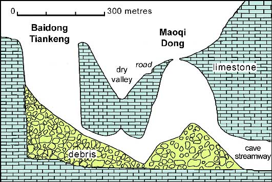
Fig. 1. Section through Baidong Tiankeng and the adjacent skylight chamber of Maoqi Dong which may be regarded as a proto-tiankeng; the bedrock profile beneath the debris piles is conjectured.
Tiankeng profiles
A tiankeng is distinguished by having vertical or sub-vertical walls for much of its depth and round most of its perimeter. They are among the clearest evidence of collapse origins, though they may be due either to failure into an underlying cave or to subsequent face retreat. Vertical cliffs are dependent on geological structure; they develop best in strong and massive limestones, and primarily where fractures are close to vertical, which tend to be more dominant in beds of low structural dip. Limestones dipping at around 45° tend to have similarly inclined fractures that preclude development of steep tiankeng profiles. Tiankengs with depths greater than their widths tend to be the more spectacular, but the key factor in the visual spectacle is the completeness of a ring of high cliffs (Fig. 2); Huangjing Tiankeng (Guangxi) and Minyé (New Britain) are therefore prime examples.
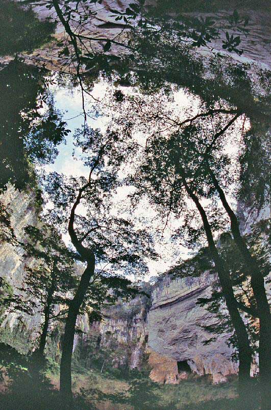
Fig. 2. The complete ring of vertical cliffs of Huangjing Tiankeng, Guangxi, seen in a very wide upward view from the floor.
Degraded tiankengs are those that have lost a significant proportion of their perimeter cliffs. The inevitable retreat of an exposed face, by weathering and successive rockfalls, creates an apron of scree debris at the base of the cliff. In an active tiankeng, rockfall debris is removed by the cave river, so that only modest scree ramparts of debris remain beneath the cliff faces, as at Xiaozhai Tiankeng (Chongqing) and Velika Dolina (Slovenia). Where the cave river is too weak or is lost to a by-pass route, breakdown debris accumulates until it may mask much, or all, of the cliff faces. Progressive degradation sees the perimeter cliff faces reduced in height and perhaps also broken by gully development. There is an inevitable evolution from a tiankeng like Naré (New Britain), to a degraded tiankeng such as Datuo (Guangxi), and then to a mega-doline such as Garden of Eden (Sarawak). There are no clear boundaries between the three forms (see below).
The bedrock floor of a tiankeng is largely or wholly masked by broken rock debris as an inevitable consequence of its collapse origins. This may be a single pile or ramp of breakdown from a cave roof failure. It is more commonly a convergent series of fans and aprons of debris created by subsequent failures of the retreating perimeter cliffs. Some active tiankengs have an exposed cave river across their floors; others only have an underground river flowing through their floor debris, and this may or not be accessible. Tiankengs such as Qinlong (Chongqing) have small or underfit rivers flowing between dominating ramps of debris, while most degraded tiankengs no longer have any sign of a cave river. Entrances to cave passages should be a feature of any tiankeng, but they are commonly obscured behind accumulated rockfall debris; these should include active inlet and outlet caves at floor level, and may include older passages at higher levels, as at Xiaoyanwan (Sichuan).
Tiankeng development
A tiankeng is a collapse features formed over a large underground cave passage. It may develop by collapse of a single large chamber, as appears to be the case at Xiaozhai Tiankeng in Chongqing. Alternatively, a tiankeng may form by collapse at the junction of a series of large passages, which includes collapse through superimposed levels of passages that are of varied ages, as at Xiaoyanwan in Sichuan. Cave roof collapse normally involves prolonged roof stoping and upward cavity migration. Within this, a long sequence of progressive failures cause small quantities of rock fall from the tensile zone beneath the compression arch (which creates the stable roof span within the rock spanning the void). The ultimate failure through to the ground surface may then be a single event. Alternatively, the surface failure may be by multiple events, with coalescence of smaller collapses. Some tiankengs are elongate due to collapse along the line of very large cave passages; Qinlong Tiankeng (Chongqing) and Dacaokou (Guizhou) provide fine examples (Fig. 3). The very large size of some tiankengs suggests that they are multiple failures; they are inordinately larger than known cave chambers, and much of their volumes is accounted for by the removal of debris from the base by dissolution and erosion. The rounded shape of many tiankengs is likely to have evolved by cliff retreat (where stress distribution favours failure towards a stable circle).
Most observed tiankengs expose within the limestone one or more structural weaknesses, notably sub-vertical faults and joints. Xiaozhai Tiankeng (Chongqing) provides an example, where the cave river crossed intersecting, sub-vertical fractures that appear to be small-displacement faults (Fig. 4). These facilitated the processes of vertical expansion by roof stoping, as well as lateral expansion by wall retreat and coalescence of collapses. Such structures are however not unique to tiankengs, as nearly all cave passages and chambers have developed at some form of structural weaknesses.
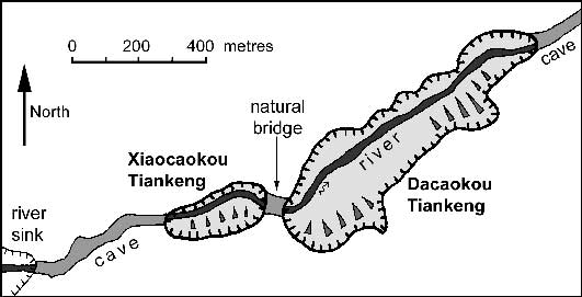
Fig. 3. The tiankengs of Dacaokou and Xiacaokou, separated by a natural bridge, all formed along the course of the Yijie underground river in Guizhou.
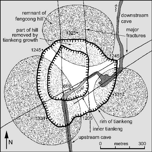
Fig. 4. Structural interpretation of Xiaozhai Tiankeng, Chongqing, with the observed fractures that may have initiated tiankeng development over the Difeng cave river and beneath a doline between three hills within the fengcong karst. The fracture traces are simplified; those along the cave passages are multiple fracture sets, and the SW-NE fractures may break into en echelon series.
A large underground river is an essential feature of an active tiankeng, as it provides the only means by which the huge volumes of missing rock can be removed, either in solution or as clastic sediment. This is commonly a vadose cave river, but the flow may be phreatic. The erosional ability of the cave river relies on the supply of broken rock that is provided by progressive roof stoping and wall failure. Steeper hydraulic gradients through a breakdown pile also enhance rates of dissolution and erosion (Palmer and Palmer, this volume). Large wall undercuts are common in tropical caves where water flow is deflected around a pile of collapse debris; they contribute to the enlargement of cave chambers and tiankengs alike. Wall undercutting is also enhanced on the outside of a bend in a cave passage, as may be the case at Xiaozhai (in Chongqing). Roof stoping and cave river transport are synergic in tiankeng development - which only proceeds when both processes are active on a large scale.
The relationship of tiankengs to large underground rivers ties them to the wet tropical environment or to situations in other climates where allogenic rivers are swallowed into karst to produce large cave river passages. This criterion also separates tiankengs from other giant collapse features, including caprock collapses over evaporites (as in Canada and Russia) and large collapses over hydrothermal cavities (as in Oman), which do not classify as tiankengs.
The huge, circular, collapse doline of Sarisarinama, in Venezuela, has developed in quartzite by piping and clastic sediment removal on a massive scale. Except for the fact that it is not in limestone, it would be regarded as a tiankeng, yet there is no cave river associated with it. This may be explained by an exceptionally long period of very slow evolution, but the site may have implications with respect to the processes that develop tiankengs in limestone.
Development in the vadose zone
Tiankengs are deep open holes that lie within the vadose zone of the karst. An active tiankeng may have a cave river across its floor (or through the debris on its floor); this cave drainage is normally vadose, but is phreatic at some sites. Vadose conditions also maximise stress on a cave chamber roof, which lacks the buoyant support of a completely phreatic chamber. But a tiankeng may not be a wholly vadose feature. Of the recorded tiankengs, about half have no known cave river flowing through them or directly associated with them. However, half of these river-less tiankengs do have associated cave passages that carried underground rivers in the past, and some may have rivers that pass unseen through their floor debris. Some tiankengs, including Xiaoyanwan in Sichuan, formed by collapse into large phreatic passages, where there is no sign that they have positively evolved within the vadose zone. Crveno Jezero (Croatia) has active phreatic cave drainage that is removing the collapse debris beneath the water-table.
Any large cave chamber may collapse to form a tiankeng, as long as through-drainage removes enough of the breakdown material to create a deep open hole. Furthermore, virtually all caves and cave chambers have some phreatic origins that were developed prior to their drainage. Vadose modification of a large, open, de-watered shaft or collapse doline is inevitable, but vadose erosion may not be the dominant process that forms a tiankeng. Lago Azul, in Brazil, has the dimensions of a tiankeng, but is clearly phreatic because it is full to the brim with water. Eventually, regional rejuvenation will cause its drainage, and it will then have a morphology very similar to that of Golondrinas, in Mexico. This may be an extreme case of early phreatic enlargement - that will be unrecognisable once the feature is in vadose zone and is modified by vadose erosion and wall collapse. Lago Azul may warrant description as a proto-tiankeng. The same applies to the very deep cenote of Zacaton, in Mexico, but this may partly owe its size to corrosive waters rising from a volcanic source rich in with hydrogen sulphide. These sites questions whether, or to what extent, vadose development should be an essential criterion of a tiankeng.
It is debatable to what extent solution dolines have contributed to the development of tiankengs. The growth of a doline would reduce roof thickness over an underlying cave chamber, thereby hastening the eventual collapse, and it would also direct more drainage into the site, thereby enhancing localised rock dissolution. A solution doline could be expected to form on the same structural weaknesses that guide the chamber development underneath it. The cave of Zhucaojing in the Xingwen karst of Sichuan (Waltham, this volume) has deep solution dolines above its large chambers, and appears to be a clear example of imminent tiankeng development. In contrast, some tiankengs in China breach steep hillsides where no large solution dolines are likely to have developed. Many tiankengs in China appear to be completely independent of the surface morphology, in that their walls cut through dolines and conical hills alike (Fig. 5). However, cutting into the cones is enhanced by the wall retreat that expands the tiankengs. At many sites, the distribution of the cone remnants cut by the perimeter walls does leave space for the tiankeng to have originated at a central solution doline within the fengcong terrain (Fig. 4). It appears that solutional dolines have contributed to the development of many tiankengs, but they were not essential features; the evidence was destroyed by the collapses that eventually formed the tiankengs.
Most of the tiankengs in southern China lie within the terrains of mature fengcong with high local relief that are so typical of the karst region. In New Britain and Puerto Rico, tiankengs lie in cone karst with much less local relief, and those elsewhere lie in karst terrains that are not fengcong. Though deeply dissected fengcong may be the ideal environment for tiankengs, it does not appear to be a criterion for their development.
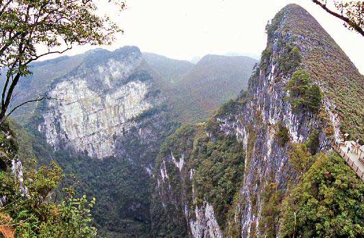
Fig. 5. Remains of two fengcong karst hills truncated by expansion of Dashiwei Tiankeng in the Leye karst of Guangxi, seen from the flank of a third truncated hill.
Erosional tiankengs
A sub-class of tiankeng, the erosional type, has been recognised within China as distinct from the more common collapse type (Table 1). An erosional tiankeng develops at the site of a sinking allogenic stream, as distinct from collapse tiankengs that are independent of surface drainage. The erosional type therefore has a cave stream draining from it, but not into it. Qingkou Tiankeng in Chongqing is therefore an excellent example (Fig. 6).

Figure 6. One of the waterfalls that cascade into Qingkou Tiankeng (Chongqing), which all drain out through a large stream cave.
The relative roles of collapse and waterfall erosion appear to vary widely between sites. Some large holes in karst are just greatly enlarged solutional shafts, typically with a high depth/width ratio (d/w>5). There must be some elements of collapse, shaft coalescence and/or wall retreat to enlarge these to the dimensions of an erosional tiankeng, as a single waterfall shaft either retreats into a sinuous canyon or bells out to no more than about 20 m wide. Similarly stream erosion has contributed to the erosion of many collapse tiankengs. Xiaozhai Tiankeng (Chongqing) has three waterfalls descending its walls in wet weather, but these are fed by immediate run-off from the limestone.
Some erosional tiankengs are large caprock dolines, as they have formed by collapse within underlying limestone that has propagated to the ground surface through a cover of insoluble rock. These therefore gather significant allogenic drainage off the surrounding cover. Others only gather allogenic input from adjacent outcrops of cover rock. Furthermore, it is open to debate whether many other tiankengs, especially in the Leye karst in Guangxi, collected allogenic drainage before retreat of the margin of the cover rocks.
The separation of erosional tiankengs from collapse tiankengs therefore appears to be dubious. It is better to regard both as end members of a spectrum of conditions, where collapse and dissolution vary in their relative importance. Both processes contribute to the development of all tiankengs, which may therefore be described as polygenetic.
Degraded tiankengs
An inevitable process in tiankeng evolution is wall retreat, but this only contributes to enlargement while a river is removing the breakdown debris, as is conspicuous at Kukumbu in New Britain. When the rate of debris accumulation exceeds the rate of removal, a tiankeng starts to degrade, as ever larger fans and aprons of scree accumulate at the base of the walls. This rockfall debris from the walls is added to debris remaining from the earlier roof failure. A degraded tiankeng has its perimeter cliffs progressively buried by the aprons of scree, while the rim is being lowered at the same time, and the depth/width ratio therefore decreases (d/w<0.5). Ultimately, trees grow to mask the rock debris. Of the 74 recorded tiankengs, at least 12 are properly described as degraded (Zhu and Chen, this volume, Table 1; Waltham, this volume, Table 1).
|
Table 1 |
||
|
collapse tiankeng |
erosional tiankeng |
|
|
gross morphology |
vertical or overhanging walls |
vertical walls |
|
wall features |
collapse scars |
waterfall gullies |
|
dominant process |
collapse |
erosion |
|
origin |
collapse of cave chamber |
large waterfall shaft |
|
mass transport |
by cave river flowing through |
by river sinking into cave |
|
growth direction |
upwards from cave river |
downwards from sink |
|
relationship to cave river |
cave river pre-dates tiankeng |
tiankeng contemporary with cave river |
|
hydrology |
vadose, or partly phreatic |
vadose |
|
floor material |
mainly breakdown debris |
alluvium and breakdown |
|
floor topography |
river buried or at margin |
river bed to cave outlet |
|
relationship to |
no correlation in fengcong, |
in valley or depression, |
|
abundance |
many |
few |
|
age (in China) |
since early Pleistocene |
since late Pleistocene |
There is a clearly recognisable evolution of a tiankeng into a degraded state, and beyond. Ultimately, a tiankeng degrades so much that almost all its perimeter cliffs are lost, and it is then regarded as a mega-doline. Many very large dolines could have originated as tiankengs, and it may be questioned as to how many deep dolines within very mature, high-relief, fengcong karst originated as tiankengs. However, it may be unhelpful to describe these large dolines as heavily degraded tiankengs, as this blurs the concept of the tiankeng. Similarly, a tiankeng could be regarded as a sub-type, or a stage in the evolution of, a mega-doline, though such would not be the origin of all mega-dolines.
The age of tiankengs requires further investigation. Ages of the large tiankengs in the Nakanai karst on New Britain were estimated at 200-300 ka, but this was only based on the overall rate of surface lowering (Maire, 1981). Most tiankengs in China are relatively youthful features, as they truncate the topography of solution dolines and conical hills within the fengcong karst. However, such evidence only dates the surface collapse that created the open tiankeng, and solutional and stoping development of the underground cavern must have taken longer. The sheer size of many tiankengs suggests a very long history to allow time for erosional removal of the huge volumes of missing rock.
Classification of tiankengs
Tiankengs may be classified as a very large sub-type of collapse doline (Waltham et al, 2005). Some may be classified as caprock tiankengs, and these would include most erosional tiankengs if that sub-type is accepted. They are distinguished from collapse and caprock dolines by their very large size.
It is appropriate to use a three-fold sub-division of tiankengs that is already applied in China (Zhu and Chen, this volume) -
Very large tiankengs are more than 500 m in diameter and depth.
Large tiankengs are 300-500 m in diameter and depth.
Normal tiankengs are 100-300 m in diameter and depth.
Smaller features are large collapse (or caprock) dolines.
These limiting dimensions should be interpreted loosely and with discretion. A large tiankeng should have its depth and length greater than about 300 m, though its width may reach rather less than that figure. Maximum dimensions of a tiankeng with very irregular shape may give a false impression of its size; Xiashiyuan and Zhongshiyuan, in Chongqing, both have large maximum dimensions that belie their relatively shallow but inclined structure in a slope that follows the limestone dip. The depth would sensibly be measured from the mean level of the rim, and not from the highest point (as is cited in Chinese literature), but the mean figure is rarely available. In theory, the depth of a tiankeng should be measured to the base of the debris pile over its rock floor, but this depth cannot be determined at some sites.
It could be more precise to sub-divide tiankengs on the basis of their volumes. The disadvantage of this is that volumes are not so easily or frequently measured with any degree of accuracy (most of the figures quoted in the tables in this volume are very rough estimates from basic maps). The minimum volumes for normal, large and very large tiankengs are about 1M, 10M, and 70M m3.
Within some karst regions in China, tiankengs have become part of the local culture. Some features so described have depths and diameters of 50-100 m, and are described as small tiankengs, though in other parts of the world these would be described only as large collapse dolines. Because a tiankeng is defined as a large collapse doline, a small tiankeng would be a "small large collapse doline", and this is unacceptable in a widely used term. To include features with all dimensions less than 100 m detracts from the value of the tiankeng as a distinctive feature.
There are 75 recorded tiankengs worldwide, including 49 in China. Of these, only 3 are very large, and are all in China. Then there are 16 large tiankengs, of which 9 are in China. The other 56 are normal tiankengs, of which 37 are in China. There are also many hundreds of large collapse dolines, both within and outside China.
Tiankengs do not lend themselves readily to a Davisian sequence of evolution, due to the instantaneous cave roof collapse by which they are formed. A mature tiankeng is distinguished by its almost complete perimeter cliffs that are close to vertical (Fig. 7). An immature tiankeng is one with overhanging cliffs due to incomplete collapse of the original cave chamber, as a consequence, the surface opening is significantly smaller that the floor area (wt/wb<0.7). There is no benefit in retreating further on the evolution chain by defining a youthful tiankeng. A large cave chamber with a thin roof or a small skylight (or a flooded chamber) may eventually collapse to form a mature tiankeng, but is better described as a proto-tiankeng prior to its roof failure; it does not yet have the appearance of a tiankeng. A degraded tiankeng still retain its large dimensions and many sections of perimeter cliff, but its floor is much smaller than its surface area (wt/wb>1.5). It has an excess of debris on its floor and in ramps up its perimeter, and has no cave river through it. It could be described as one of old age, but description as degraded is more helpful. There is no clear borderline between a degraded tiankeng and a large doline or mega-doline.
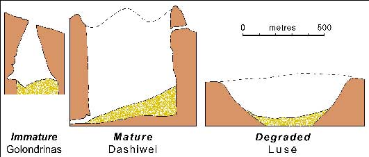
Fig. 7. Comparative profiles of good examples of immature, mature and degraded tiankengs.
Tiankeng karst
The concept of tiankeng karst has been considered within China as a term to describe an extremely mature type of karst landscape that has matured beyond normal fengcong karst with high relief. The term could be used to describe the Leye karst in Guangxi, China, and perhaps the Nakanai karst in New Britain, Papua New Guinea, both of which are distinguished by unusually large numbers of tiankengs. However, some mature karst terrains contain just a few tiankengs, notably just two in each of the karsts of Xingwen, Croatia and Mexico, and these question the applicability of the term. Tiankeng karst may be purely descriptive of the Leye and Nakanai terrains, but the term has not yet been shown to have any geomorphological status with reference to karst evolution.
Conclusions
The tiankeng is recognised as a significant karst landform. The key features of a tiankeng may be summarised as -
- It is a distinctive type of very large collapse doline.
- It is more than 100 m wide and deep, with a depth/width ratio close to unity.
- It has vertical cliffs round most of its perimeter.
- It was formed by collapse of a large cave chamber into a large cave river.
- Surface lowering within a solution doline may have contributed to this collapse.
- Tiankeng development is largely in the vadose zone within deeply dissected fengcong karst.
- Some tiankengs are partly eroded by sinking allogenic streams.
- Immature tiankengs bell out to floor areas that are larger than their surface openings.
- Degraded tiankengs have most of their perimeter cliffs masked by rock debris.
These properties constitute an appropriate definition of a tiankeng. It is difficult and unnecessarily pedantic to define absolute limits to large collapse dolines that might be too small or too degraded to be regarded as tiankengs, or may be of a different genesis. Tiankeng is a useful addition to the international lexicon of karst terminology. As a distinctive landform, a tiankeng fits within the spectrum of dolines and karst depressions that characterise karst terrains. Though tiankeng research originated in China, the term is applicable in karst terrains elsewhere.
This paper originated from a discussion meeting held in Guilin at the end of the Tiankeng Investigation Project in 2005. A draft text was circulated to all delegates, and was approved by all after incorporating amendments. Delegates at the meeting were Chen Weihai, Andy Eavis, John Gunn, Julia James, Alexander Klimchouk, Andrej Kranjc, Liu Zaihua, Art Palmer and Will White, and the editors. The paper is therefore intended to accord international recognition to the research and work on tiankengs that was initiated and developed at the Institute of Karst Geology in China.