Tiankengs of the world, outside China
Waltham T.
Abstract: An inventory of tiankengs that are known outside China is accompanied by brief descriptions and comments on their features and origins. Available data suggests that there are only 26 known tiankengs outside China. Some other very large collapse dolines are compared.
Keywords: tiankeng, karst, doline, world.
Introduction
Though tiankengs were first distinguished and described from the karst of China, a small number of comparable features can be seen in various karst regions around the world. This paper simply records the very large collapse dolines that have been documented outside China, and which may justifiably be described as tiankengs in the context of the landforms in China. A tiankeng is defined as a collapse doline at least 100 m long, wide and deep, and with perimeter walls that are close to vertical (Zhu and Waltham, this volume).
The paper was prepared at the request of Prof. Zhu for the 2005 Tiankeng Investigation Project, and is presented as a companion paper to that on the tiankengs inside China (Zhu and Chen, this volume). It includes reference to various very large dolines that do not quite fit the definition of a tiankeng, but it excludes features that are less than about 100 m deep and wide, even though some of these would be known as small tiankengs within China.
There are probably more tiankengs that are yet to be discovered. Unseen tiankengs could await discovery in some of the more remote karst highlands of the tropics, and more may be found in the forested mountainous karsts of China and New Britain. Satellite imagery is making such discoveries less likely, but this inventory cannot yet be regarded as complete.
Known tiankengs
Nakanai, New Britain
The one karst terrain of the world that compares to those in China, in terms of the large underground rivers and many tiankengs, is the Nakanai Mountains of New Britain, the island off the north coast of Papua New Guinea (Maire, 1981; Audra et al, 2001). Unlike the precipitous Chinese fengcong karst, the Nakanai is a polygonal karst with modest cone development and local relief of about 100 m, and it still bears the remnants of a clay cover. However, it is broken by eight deep canyons and at least eight giant dolines (Table 1).
|
Table 1 Dimensions of known tiankengs outside China and some comparable features. The quoted data are the best available estimates, either previously published or measured off surveys; except for the depths at some sites, all figures are only approximations, as the wall profiles have not been mapped in detail. L = large; D = degraded; I = immature. |
|||||||
|
Tiankeng |
length x width m |
area m2 |
depth max m |
depth min m |
volume M m3 |
size |
type |
|
Nakanai, New Britain |
|||||||
|
Minyé |
350 x 350 |
75,000 |
510 |
400 |
26.0 |
L |
|
|
Naré |
150 x 120 |
13,000 |
310 |
240 |
4.7 |
||
|
Poipun |
150 x 150 |
17,000 |
160 |
110 |
1.7 |
||
|
Bikbik Vuvu |
190 x 120 |
15,000 |
225 |
190 |
1.5 |
||
|
Kea 2 |
130 x 110 |
11,000 |
125 |
100 |
1.2 |
||
|
Lusé |
800 x 600 |
350,000 |
250 |
224 |
61.0 |
L |
D |
|
Kavakuna |
380 x 300 |
80,000 |
480 |
360 |
12.0 |
L |
D |
|
Wunung |
500 x 400 |
160,000 |
160 |
150 |
24.0 |
L |
D |
|
Ora |
900 x 550 |
240,000 |
275 |
270 |
26.0 |
L |
D |
|
S E Asia Islands |
|||||||
|
Kukumbu (New Britain) |
1000 x 700 |
380,000 |
300 |
280 |
75.0 |
L |
|
|
Yogoluk (West Papua) |
180 x 180 |
25,000 |
240 |
230 |
4.0 |
||
|
Sendirian (Sarawak) |
115 x 90 |
12,000 |
240 |
180 |
2.0 |
I |
|
|
RMAF Hole (Sarawak) |
150 x 120 |
13,000 |
110 |
80 |
1.3 |
||
|
Himbiraga (Papua New Guinea) |
400 x 200 |
72,000 |
>100 |
100 |
~5.0 |
||
|
Slovenia |
|||||||
|
Velika Dolina |
300 x 170 |
30,000 |
165 |
120 |
3.5 |
||
|
Mala Dolina |
170 x 120 |
14,000 |
130 |
95 |
1.0 |
||
|
Lisičina |
400 x 200 |
60,000 |
115 |
80 |
2.0 |
D |
|
|
Croatia |
|||||||
|
Crveno Jezero |
450 x 400 |
140,000 |
528 |
431 |
30.0 |
L |
|
|
Modro Jezero |
700 x 400 |
190,000 |
290 |
160 |
22.0 |
D |
|
|
Mexico |
|||||||
|
El Sotano |
440 x 210 |
70,000 |
455 |
310 |
16.0 |
L |
|
|
Golondrinas |
300 x 130 |
26,000 |
400 |
355 |
5.0 |
I |
|
|
Brazil |
|||||||
|
Peruaçu North |
450 x 200 |
85,000 |
170 |
130 |
10.0 |
||
|
Peruaçu South |
400 x 180 |
55,000 |
150 |
70 |
5.0 |
D |
|
|
Puerto Rico |
|||||||
|
Tres Pueblos Sink |
190 x 180 |
25,000 |
120 |
90 |
2.5 |
||
|
Madagascar |
|||||||
|
Mangily |
700 x 500 |
280,000 |
140 |
100 |
25.0 |
||
|
Styx 2 |
400 x 300 |
88,000 |
140 |
100 |
8.0 |
||
|
Other sites |
|||||||
|
Pozzatina (Italy) |
675 x 440 |
240,000 |
130 |
104 |
14.0 |
||
|
Pulicchio (Italy) |
710 x 550 |
280,000 |
100 |
90 |
15.0 |
||
|
Garden of Eden (Sarawak) |
1200 x 800 |
750,000 |
300 |
150 |
150.0 |
||
|
Sarawak Chamber (Sarawak) |
700 x 300 |
165,000 |
200 |
90 |
15.0 |
||
|
Lago Azul (Brazil) |
200 x 140 |
18,000 |
280 |
265 |
4.3 |
||
|
Zacaton (Mexico) |
115 x 100 |
8,000 |
350 |
330 |
2.8 |
||
|
Sarisarinama (Venezuala) |
340 x 300 |
80,000 |
315 |
295 |
21.0 |
||
Dimensions of known tiankengs outside China and some comparable features. The quoted data are the best available estimates, either previously published or measured off surveys; except for the depths at some sites, all figures are only approximations, as the wall profiles have not been mapped in detail. L = large; D = degraded; I = immature.
Minyé is a large tiankeng, and is one of the largest and finest in the world (Fig. 1). Almost circular, it is entirely ringed by tree-covered walls that are precipitous but only vertical in parts (Fig. 2); the Minyé floor is crossed by a river of 25 m3/s, though the explored cave passages are neither large nor long. Naré is smaller (Fig. 2), but its vertical and overhanging walls perhaps make it even more spectacular (Fig. 3); it drops straight into a river passage some 50 m high and wide that can be followed in both directions, though the flow of 15 m3/s provides endless difficulties.
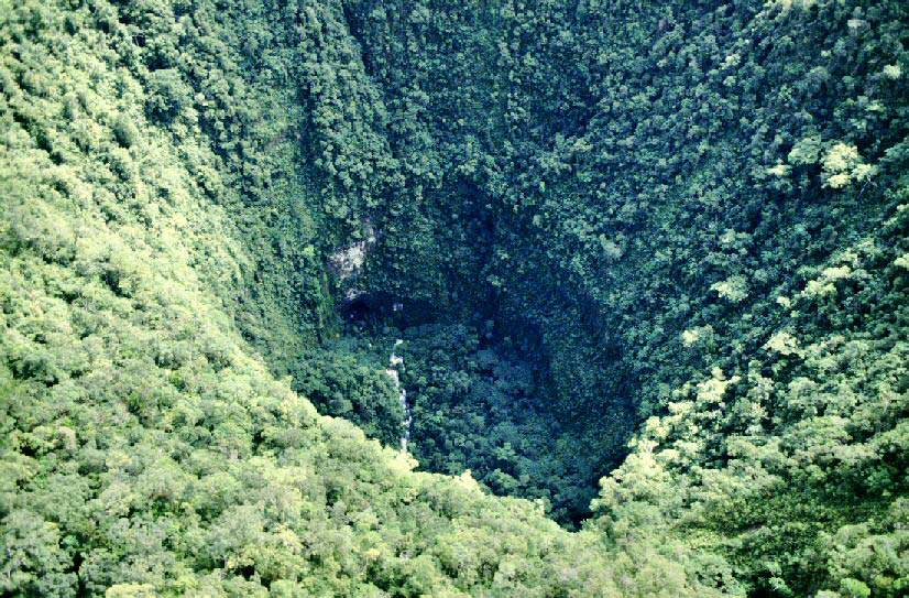
Fig. 1. Looking down into the Minyé tiankeng, in the Nakanai karst in New Britain. (Photo: Jean-Paul Sounier)
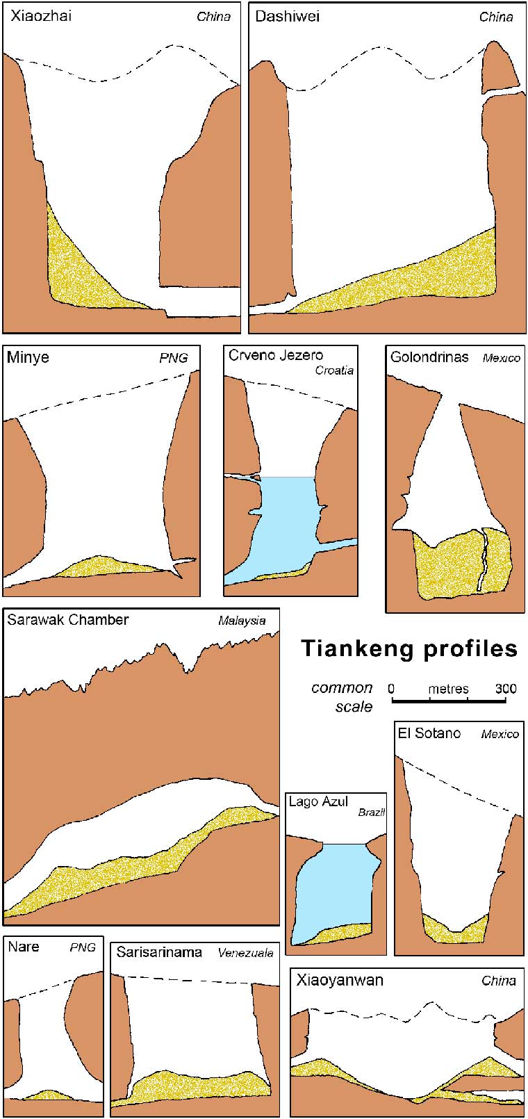
Fig. 2. Profiles of some tiankengs and giant dolines; rock profiles beneath debris are conjectured.
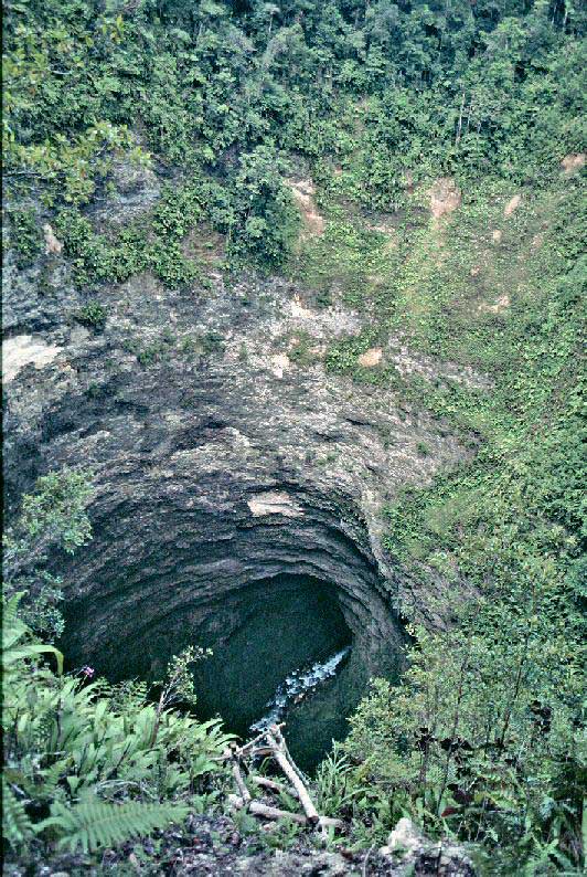
Fig. 3. Looking down the Naré tiankeng (Nakanai) towards the downstream river cave. (Photo: Jean-Paul Sounier)
Bikbik Vuvu has almost vertical tree-shrouded limestone walls tapering slightly down to a bedrock floor; its downstream cave is a canyon 15 m wide and 40 m high, while a subaerial slot canyon carries a flood river into the upstream side of the tiankeng. Poipun is more degraded, so that accumulated breakdown debris obscures any access to the cave below. Kea 2 has vertical walls, but its floor is partly alluviated. Within the Nakanai karst, there are many other collapse dolines of only slightly smaller dimensions; some of these would be described as small tiankengs in China, but do not match the 100 m dimensions of a normal tiankeng.
Minyé and Naré are classic, active and mature tiankengs, while Bikbik Vuvu and Poipun are of only slightly lesser stature. These Nakanai tiankengs compare well with the sites in China, in that they are all youthful features in a very active karst with deep vadose drainage. However, they show more solutional activity than collapse in their evolution. The inlet river to Bikbik Vuvu means that it may be classified as an erosional tiankeng, if that distinction is accepted.
With a volume of about 61M m3, Lusé is the largest of three degraded tiankengs. More than 600 m across, it is floored by breakdown debris and dense forest with no visible river, and there are hardly any surviving cliffs around its perimeter (Maire, 1981). Wunung is rather smaller (Table 1), but does have steeper walls on parts of its perimeter. Kavakuna has a vertical wall on one side, but this faces a massive debris slope that reaches from lip to floor on the other side, and the cave passage is offset below. Though significantly degraded, these three sites have profiles that are comparable to some of the degraded tiankengs in China. Ora is a fourth degraded doline, and is a double feature with a central rock bridge (Audra et al, 2001); it clearly developed in association with the cave river that crosses the floor. Ora is a large tiankeng, but its side slopes are now so degraded and flared out that it stands on the boundary between a tiankeng and a mega-doline.
Southeast Asia Islands
On the mainland of Papua New Guinea, the Muller Range contains perhaps the world's greatest density of giant dolines on the Mamo Plateau (James, this volume, Fig. 4). They are mainly giant caprock dolines, and their perimeters lack major cliffs because they are degraded in the weak and thinly bedded caprock. Some large solution shafts, open to daylight in the underlying limestone, have the profiles but lack the dimensions of tiankengs, and none is known to be associated with a major cave river. Most of these dolines have only been seen from the air, but future fieldwork on the ground may reveal that some of them could be described as degraded erosional tiankengs. On the adjacent Atea Plateau, a giant doline near the Himbiraga dry valley has been visited, and does have a perimeter of sub-vertical cliffs; very rough estimates of its dimensions are therefore included in Table 1.
On New Britain island, Papua New Guinea, the Whiteman Range lies far to the west of Nakanai. Within its extensive karst, the Kukumbu tiankeng is a massive and partially degraded collapse feature a kilometre long (Table 1), midway along the large, multi-level passages of the Arrakis cave system (Beck, 2003).
In central West Papua (previously known as Irian Jaya, the Indonesian section of the New Guinea main island), the Wamena karst contains the tiankeng of Yogoluk, formed by roof collapse into a fragment of very large, abandoned cave passage (Fig. 4). Its depth is partly obscured by a debris pile around 80 m high (White, 1986). Another large collapse doline, seen from the air on the forest-covered plateau to the south, nay also be a tainkeng (Fig. 5).
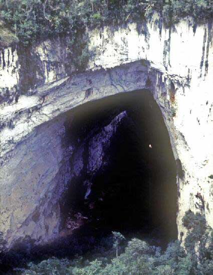
Fig. 4. The tiankeng of Yogoluk in the Wamena karst of West Irian. (Photo: Andy Eavis)
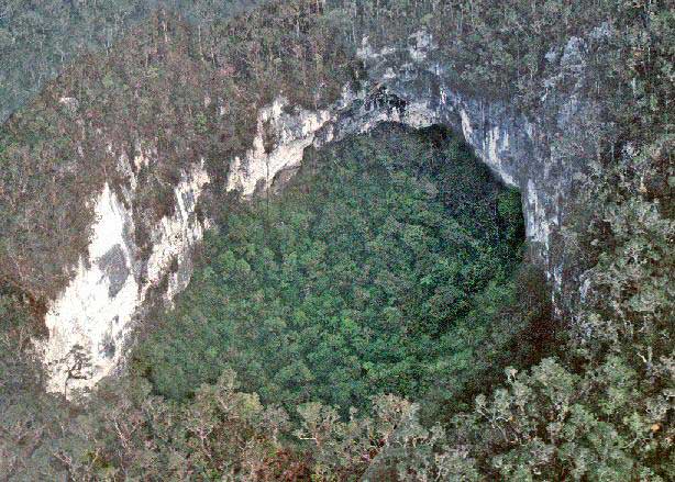
Fig. 5. An unvisited collapse doline on the plateau south of Wamena in West Irian. (Photo: Andy Eavis)
Only two tiankengs have been discovered to date in the steep, forest-clad mountainside that surface the very well developed and highly cavernous karst of Mulu, in the Malaysian sector of Borneo. Sendirian (also known as Solo) is a massive hole about 100 m across with overhanging walls that bell out below in the profile of an immature tiankeng (Fig. 6); it is around 200 m deep except for the massive debris pile on its floor (Brook and Waltham, 1978). RMAF Hole is a little wider though not so deep (Table 1), and has vertical or overhanging walls (Eavis, this volume, Fig. 4). Both tiankengs have formed by collapses into old, phreatic, high-level passages of the Clearwater Cave system.

Fig. 6. The Sendirian tiankeng in the Mulu karst of Sarawak. (Photo: Andy Eavis)
Dinaric karst
In the heart of the Dinaride mountains, the Imotski karst lies in southern Croatia, very close to the border with Bosnia. Crveno Jezero (Red Lake) takes its name from the towering, red-stained, limestone walls that surround its dark lake (Kranjc, this volume, Fig. 3). This is a classic tiankeng, 400 m across at its rim and half that size at the lake surface over 200 m down (Fig. 2). The lake is over 200 m deep, with vertical walls to a sloping debris floor; these are broken by flooded caves that provide through-flow drainage. Less than a kilometre to the east, Modro Jezero (Blue Lake) is a partially degraded tiankeng whose open aspect allows sunlight to colour its lake (Fig. 7). Vertical walls around most of the rim stand over ramps of scree that descend into the lake, whose depth varies from 100 m to nil in response to seasonal rainfalls. This appears to be an older tiankeng that was, before its degradation, very similar in size and shape to the present Crveno Jezero (Table 1).
On the margin of the Kras (the classical karst) in Slovenia, Škocjanske Jama is a famously large cave that breaks through two tiankengs just downstream from its sink (Fig. 8). Velika Dolina (Great Doline) is 170 m across and 155 m deep, with broken cliffs, partly clad in trees, around much of its perimeter (Table 1). Mala Dolina (Small Doline) is about 130 m wide and deep, and also has a perimeter that is a mix of vertical cliffs and tree-clad slopes. The two tiankengs are separated by a massive rock bridge over the cave river (Kranjc, this volume, Fig. 1). It is clear that both these tiankengs have collapsed into the cave passages of Škocjan, which include large old high-level galleries as well as the active and very large streamway (Habic et al, 1989). The adjacent Lisiĉina collapse doline is a third tiankeng, but it is inactive and partly degraded; cliffs now form only part of its perimeter. It lies on the line of an abandoned input cave from the limestone margin at an earlier ponor that has now evolved into the Sapendol doline (Fig. 8), and their floors only descend to the altitude of the old high-level passages in Škocjanske Jama. When these three tiankengs coalesce by further wall retreat, they could appear as a single mega-doline 800 m long and 300 m wide, though by then this will have degraded beyond description as a tiankeng.

Fig. 7. The tiankeng of Modro Jezero (Croatia), with its lake about 80 m deep, though it can drain down to a dry floor almost level with the floor of the Imotsko polje (visible in the background).

Fig. 8. Outline map of the cave passages and tiankengs at Škocjanske Jama, Slovenia.
The Dinaric karst terrains are punctuated by many more very large dolines. Those on the Kras plateau are degraded to gentle profiles and most are now less than 100 m deep, so they no longer warrant description as tiankengs (Kranjc, this volume). Further very large dolines also lie round the two tiankengs in the Imotski karst, and around the western end of Imotsko Polje; these include some that could be regarded as incipient or degraded tiankengs.
Mexico
The Sierra Madre Oriental is a major karst mountain range with many long and deep cave systems and also a small number of very large shafts and dolines (Hose, 2004a). El Sotano (also known as Sotano del Rancho del Barro) is a huge gash in a steep hillside. It is about 440 x 210 m at ground level, and tapers to half those dimensions at its floor (White and White, this volume, Fig. 13). Its sloping rim stands 310-455 m above the floor, where bedrock is masked by breakdown debris (Table 1, Fig. 2). Nearby, Sotano de las Golondrinas has an opening only 65 m long and 50 m wide, but its clean rock walls overhang so that the floor dimensions are about 130 x 250 m. It is 400 m deep, but fissures that have been followed in its floor to a depth of 512 m may indicate a deep mass of collapse debris (Fig. 2).
Both these giant shafts have only some of the characteristics of tiankengs. El Sotano tapers downwards in solid rock, which is not typical of stoping collapse; Golondrinas is immature, but wall collapse will eventually flare it out so that its surface opening is the diameter of a normal tiankeng. Neither site has any known cave passages into or out of it, and neither has any known river caves, nor lies in the catchment of one. They could be past sites of major stream sinks in a karst topography now changed by prolonged evolution, but some early history of hydrothermal enlargement cannot be ruled out.
There are other very large shafts and dolines in the Sierra Madre karst. Sotano de la Cuesta has two small skylights 170 m above the floor of a chamber 320 x 90 m in plan, and Hoya de las Guaguas has a large shaft from the surface with a large chamber off-set below it. Near to El Sotano, Culebra is a wide shaft 300 m deep with only a small roof opening to daylight. Further rock collapse may eventually turn all three of these features into tiankengs.
Brazil
The Peruaçu karst in Minas Gerais is well known for the Gruta do Janelão (Cave of the Windows), which has a massive river passage 3 km long and approaching 100 m high and wide. Associated with the cave are two giant collapse dolines that qualify as tiankengs (Table 1). The northern feature appears to be the collapsed remains of an old, abandoned, curving loop, nearly 500 m long, off the Janelão river cave (Fig. 9). It is bordered by cliffs that rise 150 m high to the plateau level, but both cliffs and floor are shrouded in primary forest; at the ends, they are broken by giant windows into the cave, and a third window into the cave lies at high level near the northern end. The southern feature is smaller and may be the collapsed remains of a large tributary passage; its perimeter cliffs are degraded along the southern side. These two dolines appear to be tiankengs of typical Chinese characteristics. Two more roof collapses have created dolines and windows into the cave, but have not yet widened to the dimensions of tiankengs.
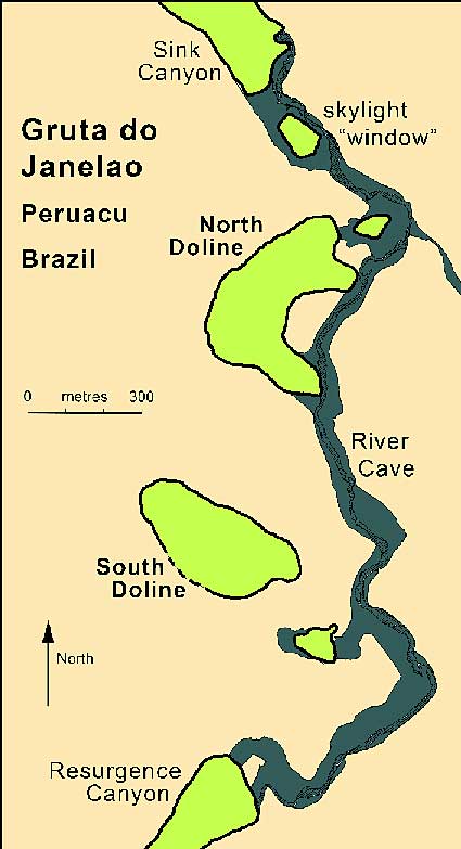
Fig. 9. Outline map of the tiankengs beside the Gruta do Janelão, Brazil.
Puerto Rico
In the western part of the limestone belt across the north of the island, Tres Pueblos Sink is a perfect collapse tiankeng in a terrain of low-relief cone karst (Table 1). It is almost perfectly round, 180 m in diameter, with vertical walls about 100 m high (White and White, this volume, Fig. 10). At the foot of a ramp of tree-clad breakdown debris, the Rio Camuy flows across the floor between portals to cave passages that are each about 10 m high and 30 m wide. There are various other collapse dolines along the same cave river, but none is as large (Gurnee et al, 1967).
Madagascar
The karst plateau of Ankarana, in northern Madagascar is well known for its stone forest (locally known as tsingy) and for its large caves inhabited by crocodiles (Peyre, 1982; Middleton, 2004). The plateau is broken by long, fault-guided canyons and a number of large collapse dolines (locally known as sunken forests), all of which have the river caves entering and leaving them at floor-level, beneath broken limestone cliffs that reach to about 150 m high. The largest doline, Mangily, is over 500 m across (Table 1). Another large collapses is the second window along the River Styx passage in the Ambatomanjahana cave, which is over 300 m across (Fig. 10). Both these dolines have perimeter walls over 100 m high, and they do appear to be related to major collapses of the large cave passages. They therefore qualify as tiankengs, though they do not lie in fengcong karst. The Styx 1 and Styx 3 windows are both segments of canyons that are enlarged joint rifts. There are other large collapse dolines, east of the Styx and further northeast on the plateau, and roof collapse has created a doline and skylight 70 m across into the Andrafiabe cave.
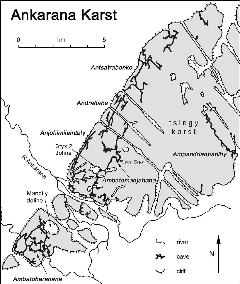
Fig. 10. Outline map of the major caves, canyons and tiankengs in the Ankarana karst, Madagascar.
Very large collapse dolines
Dolines comparable to tiankengs
Within the Mulu karst, in Sarawak, the Garden of Eden is a mega-doline that breaks the course of a very large, old, phreatic trunk passage, remnants of which are now known as Deer and Green Caves (Fig. 11). This mega-doline is about a kilometre across. Round half of its perimeter (the section close to the line of the original cave passage), steep and vertical limestone cliffs rise 150-300 m. However, the other side of the doline, along with part of the doline floor, is a rising shale slope scored by allogenic streams draining out of the rain forest. The site could therefore be described as a blind valley that happens to have breached a large cave passage. Alternatively, the Garden of Eden may be regarded as a highly degraded erosional tiankeng, with a volume of about 150M m3. Deer Cave is 100 m high and wide, and collapse of its continuation at the junction with an inlet river passage fed from the shale slopes could have created a very large doline. Such a massive collapse feature could be regarded as unlikely, until comparison is made with the nearby Sarawak Chamber (Table 1, Fig.2), which will one day collapse on this sort of scale.
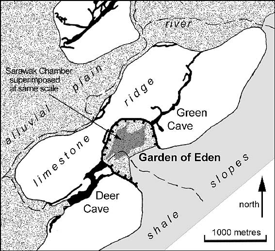
Fig. 11. Outline map of the Garden of Eden mega-doline in the Mulu karst, Sarawak, with the outline of the nearby Sarawak Chamber superimposed at the same scale for comparison.
In southern Italy, the Gargano and Murge karst plateaus are broken by some very large dolines (Table 1). The largest is the Dolina Pozzatina on the Gargano (Fig. 12). Over 500 m across, it is little over 100 m deep, and is heavily degraded; only short sections of cliff project from slopes of wooded scree that descend to a flat floor over 100 m across. The Murge plateau has two very large dolines, each about 300 m in diameter, of which the deeper is the Pulicchio, 100 m deep from a very level rim. Perimeter cliffs drop 20-30 m from the rims, to slopes of scree down to the wide flat floors. This type of large doline (locally known as a pulo) may have formed by multiple collapse and disintegration of a network of small caves, like those seen in the margin of the smaller Pulo di Molfetta; but the puli may also have origins in paleokarst dissolution features (Castiglione and Sauro, 2000). The perimeter cliffs could be due to a cap of stronger limestones higher in the horizontal sequence. With no evidence of any associated large river caves, these puli lack features of a tiankeng, and are best regarded as very large dolines.
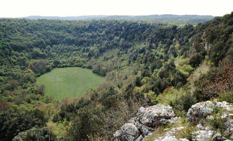
Fig. 12. The Pozzatina doline in the Gargano karst, Italy. (Photo: John Middleton)
In Brazil, a low-lying karst 200 km northwest of Brasilia contains the beautiful but innocuous blue lake known as Lago Azul. This has been dived to a sloping debris floor at depths of 220-274 m (Fig. 2); the overhanging walls flair away from the dive lines and have not been mapped in detail. The dimensions of this huge flooded shaft are therefore very close to those of Golondrinas (Table 1). Lacking a vadose environment and any known cave river, Lago Azul is not a typical tiankeng. However, after drainage due to regional rejuvenation, modification by inevitable wall collapse, and perhaps invasion by a vadose stream, its morphology would be indistinguishable from many recognised tiankengs. In Mexico, the giant cenote of Zacaton is a similar flooded cave; its diameter is less than that of Lago Azul, but its lake is 329 m deep. Unless vadose chamber development is deemed diagnostic of a tiankeng, it may be appropriate to regard both Lago Azul and Zacaton as proto-tiankengs, albeit of a slightly unusual type.
The great quartzite plateaus known as tepuis in southern Venezuela are broken by a surprising number of large shafts (Galan and Lagarde, 1988). Most of these are giant fissures, but the Sima Mayor de Sarisarinama is almost circular in plan, 300 m across and over 230 m deep (Fig. 2); it has vertical perimeter cliffs overlooking a floor of breakdown blocks shrouded in rain forest. Caves have developed along fissures in the quartzite where chemical weathering at grain boundaries leaves loose grains that are then mechanically removed by piping processes. Development of a doline with a volume of 18M m3, is a very slow process, even with collapse modification, but the tepuis are ancient structures of Precambrian rock. If Sarisarinama was in limestone instead of quartzite, it would be regarded as a splendid tiankeng, though it does lack any large cave river (both now and in the past).
Other very large dolines
The various karst regions of the world contain shafts and dolines of every shape and size, except that they do not match all the morphometric and genetic features of a tiankeng (Zhu and Waltham, this volume). However, some or all of them may be genetically related to tiankengs. The processes behind their development and evolution may be pertinent to debate over the genesis of the true tiankengs.
In western Asia, Oman has some remarkable desert karst terrains. In the Dhofar karst of southern Oman, Tawi Atair is a collapse doline 210 m deep with largely vertical perimeter walls (Fig. 13); it is 130 m across at ground level, but its lower half is an internal shaft only about 70 m in diameter. The Selma karst, in northern Oman, is broken by large shafts into both a dendritic cave system and also into the separate Majlis al Jinn (Hose, 2004b). The latter has a chamber over 200 m in diameter and 120 m high beneath a roof just 40 m thick, and this will eventually fail to create a deep collapse doline of tiankeng dimensions. All these features of the Oman karsts appear to date from wetter climates in the past, though some early hydrothermal activity could have contributed to the anomalous size of the Majlis al Jinn chamber.
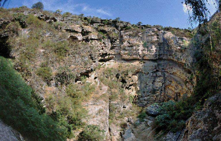
Fig. 13. The large doline of Tawi Atair, Oman, with the lower shaft dropping out of sight towards the right.
Europe has some very deep shafts in its alpine karsts, including the remarkable Vrtiglavica 643 m deep in Slovenia's Kanin massif, but these are vadose features with minimal collapse modification and few are more than about 15 m across. France's Gouffre de Padirac is more like a tiankeng and is 100 m deep, but it is less than 50 m in diameter.
North America has little of the deep karst where a tiankeng could form. Cedar Sink, in Kentucky, is an impressive doline, 250 m long and 180 m across, formed by collapse into passages within the Mammoth Cave System, but it is only 50 m deep. Deeper karst basins with partially cliffed perimeters include Grassy Cove and Icy Cove in Tennessee (White and White, this volume, Fig. 9). These are kilometres long, and have evolved by wall retreat, so that any initial cave collapse was only a small component of their development; they are not tiankengs. There are also some deep shafts and collapse dolines, but none has the width or volume of a tiankeng.
The well-developed karst of northern Jamaica contains the Linton Park Light Hole, a forest-floored collapse doline 400 m across and completely ringed by vertical cliffs that stand 45-200 m high. Nearby the Asuno and the Volcano are shafts each more than 120 m deep but only about 50 m across. These three sites are all in the catchment of the Cave River, but none qualifies as a tiankeng.
The limited extent of karst in southern Africa is distinguished by some deep flooded shafts. Lake Guinas, in Namibia, is 145 m long and 70 m wide, but it is a giant cenote 132 m deep (Fig. 14). In South Africa, Bushmangat is a flooded cave chamber 264 m deep; it is 240 x 75 m in plan at the -100 m level, but its entrance is a vertical hole only 30 m long and 12 m across. These features are not tiankengs, but they do stand comparison with Lago Azul and Zacaton (see above).
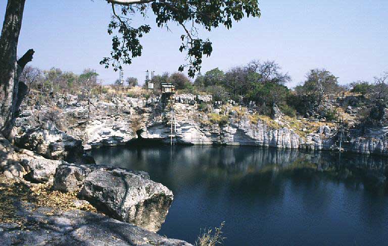
Fig. 14. The deep cenote of Lake Guinas, Namibia, with an old water supply pumping station on the far side.
The Nullarbor karst in Australia is well known for its scatter of large collapse dolines associated with cave passages that are up to 40 m wide. None matches the size of a tiankeng. Furthermore, most are now largely choked with their own collapse debris, which is not being removed in the current environment of minimal groundwater flows. Away from the Nullarbor, the Big Hole, in New South Wales, is a large caprock doline with spectacular perimeter cliffs of sandstone; it is 115 m deep but only about 60 m across. There is no evidence of a large river cave under the Big Hole, but a large solutional shaft reaches up to the base of the sandstone caprock in the nearby Wyambene Main Cave.
In Papua New Guinea, both the Mamo and Atea plateaus, in the Muller Range, have many very large dolines, most of which lack the vertical perimeter walls of a true tiankeng (James, this volume). These include the spectacular sink of the Atea River, in a doline that matches the size of a tiankeng, though it is open on one side; with its sinking river draining off a caprock, this could be equated to the erosional sub-type of tiankeng that is recognised in China. Further northwest, on the Hindenburg Plateau, Girtoil and The Sting are the two largest known collapse dolines, but both are smaller than normal tiankengs (Brook, 1976).
Comparable collapse features outside limestone
The low mechanical strength of gypsum makes it an unlikely environment for a tainkeng, except perhaps for a rather short-lived collapse feature. In the Turkish gypsum karst near Sivas, the Kizilcam doline is 350 m across and over 50 m deep to its lake. It is clearly a degraded collapse doline (Waltham, 2002), and cliffs that form many sections of its perimeter make it comparable to some of the landforms known as small tiankengs in China. The Vermillion Creek doline is a spectacular caprock doline in more than 100 m of cover shales above gypsum in northern Canada (Ford and Williams, 1989); its vertical walls are 40 m deep to a lake surface. Also in Canada, collapse features that are kilometres wide and deep over the Prairie evaporites have little or no surface expression; they are breccia pipes, and as such are clearly distinct from tiankengs.
The only exposed collapse features that do stand comparison to the limestone tiankengs are calderas that have formed by loss of support when magma pressure is reduced under a volcanic edifice. However caldera floors appear to have descended as integral blocks inside perimeter faults, due to a slow decline of magma support. This contrasts the total breakdown when a cave chamber roof collapses long after most of its support was eroded away. Most calderas are so old that they are greatly degraded, and many now have lakes in them, best known at America's Crater Lake and China's Tian Chi (on the frontier to North Korea). Katmai, in Alaska, is among the least degraded of calderas, as it was only formed during its 1912 eruption; nearly 3 km across, this caldera is 600 m deep, though it now contains a lake 300 m deep beneath its precipitous perimeter cliffs (Fig. 15). Though much older, the Trou au Natron caldera, in the Chad sector of the Sahara Desert, also appears fresh because it is little eroded. Over 6 km across and about 1000 m deep, it retains almost vertical walls above ramparts of scree that reach only half their height.
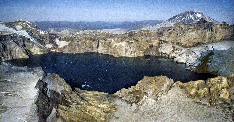
Fig. 15.The caldera on the Katmai volcano in Alaska, with its internal glacier right of the lake.
Tiankengs and collapse
By December 2005, 49 tiankengs had been identified in China (Zhu and Chen, this volume, Table 1) together with another 26 tiankengs in the rest of the world (Table 1). They all lie inside the latitudes of the tropics, except for those in China and the Dinaric karst - and these two regions are those with the greatest thicknesses of limestone in the world. All tiankengs have developed in the mature karst terrains - either those that have developed rapidly within the wet tropics, or those that have evolved slowly through huge thicknesses of limestone. Most of the known tiankengs are in well-developed fengcong cone karst, though many of the host terrains lack the local relief (cone heights) of China's fengcong. Tiankengs are undoubtedly a feature of karsts that are extremely well developed.
The world's karst contains numerous large collapse dolines, in addition to those cited in this brief but representative inventory. Many are massive, spectacular and very significant landforms, but none meets all the criteria for recognition as a tiankeng. In addition, there are many more giant dolines whose genesis is not entirely clear. Most of these are generally regarded as large solution dolines, but all have some element of rock collapse within their evolution. Where the role of cave collapse can be shown to be major, some of these large dolines could be regarded as greatly degraded tiankengs. However, this may not be helpful, as it blurs the distinctiveness of the tiankeng.
Since the fortunate demise of those uninformed times when so many limestone gorges were wildly described as "collapsed caverns", collapse has been somewhat denigrated as a major process in karst landform evolution. Slow dissolution has been seen as more important. Recognition of China's tiankengs, and subsequent re-appraisal of very large dolines in China and elsewhere, may have turned the tide in geomorphological thought. It is now difficult not to conclude that large-scale collapse of large cave passages is a very significant process in many karst terrains.
Acknowledgements
Data has been gathered from a great number of sources, and due thanks are accorded to the unnamed cavers who have produced most of the maps, notably Gilberto Menezes for unpublished data from his dives in Lago Azul; thanks also to the author's many colleagues both inside and outside the 2005 Tiankeng Investigation Project.
References
- Audra, P, Coninck, P and Sounier, J-P, 2001. Nakanai 1978-1998: 20 Years of Exploration. Association Hemisphere Sud: Antibes, 224pp.
- Beck, H, 2003. Beneath the Cloud Forests: a history of cave exploration in Papua New Guinea. Speleo Projects: Switzerland, 352pp.
- Brook, D (ed.), 1976. The British New Guinea Speleological Expedition 1975. Trans. Brit. Cave Res. Assoc., 3, 113-243.
- Brook, D B and Waltham, A C, 1978. Caves of Mulu. Royal Geographical Society: London, 44 pp.
- Castiglione, B and Sauro, U, 2000. Large collapse dolines in Puglia (southern Italy): the cases of "Dolina Pozzatina" in the Gargano plateau and of "puli" in the Murge. Acta Carsologica, 29, 83-93.
- Ford, D C and Williams, P F, 1989. Karst Geomorphology and Hydrology. Unwin Hyman: London, 601pp.
- Galan, C and Lagarde, J, 1988. Morphologie et evolution des cavernes et formes superficielles dans les quartzites du Roraima (Venezuela). Karstologia, 11, 49-60.
- Gurnee, R H., Thrailkill, J V. and Nicholas, B, 1967. Conservation through commercialization - Rio Camuy development proposals. Nat. Speleol. Soc. Bull. 29(2), 27-71.
- Habič, P, Knez, M, Kogovsek, J, Kranjc, A, Mihevc, A, Slabe, T, Sebela, S and Zupan, N, 1989. Škocjanske Jame speleological revue. Int. Journ. Speleol., 18, 1-42.
- Hose, L D, 2004a. Golondrinas and the giant shafts of Mexico. 390-391, in Gunn, J (ed.), Encyclopedia of Caves and Karst Science, Fitzroy Dearborn: New York.
- Hose, L D, 2004b. Selma Plateau caves, Oman. 639-641, in Gunn, J (ed.), Encyclopedia of Caves and Karst Science, Fitzroy Dearborn: New York.
- Maire, R, 1981. Giant shafts and underground rivers of the Nakanai Mountains (New Britain). Spelunca, Supplement 2, 8-30.
- Middleton, G, 2004. Madagascar. 493-495, in Gunn, J. (ed.), Encyclopedia of Caves and Karst Science, Fitzroy Dearborn: New York.
- Peyre, J C, 1982. Expedition speleologique Madagascar 1982. Federation Francais de Speleologie: Paris, 48pp.
- Waltham, T, 2002. Gypsum karst near Sivas, Turkey. Cave and Karst Science, 29, 39-44.
- White, T (ed.), 1986. The 1985 Indonesia expedition. Cave Science, 13, 25-45.