(2) Centre d'etudes et de recherches appliquees au karst (CERAK), Faculte polytechnique de Mons, 9 rue de Houdain, 7000 MONS, BELGIUM
(3) CEREGE, UMR 6635 CNRS, Aix-Marseille University, Europole mediterraneen de l’Arbois, 13545 Aix-en-Provence Cedex 04, France
* Corresponding author
Audra, Ph., Quinif, Y. and Rochette, P. 2003. The genesis of the Tennengebirge karst and caves (Salzburg, Austria). / Speleogenesis and Evolution of Karst Aquifers 1 (1), www.speleogenesis.net , 15 pages, re-published from: Journal of Cave and Karst Studies 64 (3), 153-164.
Abstract: Research has been carried out in the Tennengebirge Massif (Salzburg, Austria) with specific attention to karst morphology, cave systems, and sediments. This study reveals the genesis of the karst and the underground systems of the Tennengebirge, since the Oligocene. Large horizontal systems, which date back to the Miocene, were studied through the example of the caves Hornhohle and Eisriesenwelt, which respectively represent Ruinenhohlen (“cave ruins”) and Riesenhohlen (“giant caves”). The Cosa-Nostra - Bergerhohle System is typical of a mostly vertical large high-relief, alpine cave. The main characteristic of this network is major development in the vadose zone. The shafts' morphology is in “stairs beneath a faulted roof.” At greater depth, they connect to a perched epiphreatic zone, which is typical of a dammed karst. The main underground sediments are of paleoclimatic and hydrodynamic significance, corresponding to hot, stable, or unstable environments (flowstones, reworked weathered rocks) and cold environments (carbonate varves, glacial pebbles). A preliminary study of the Tennengebirge sediments reveals significant information about its evolution throughout Pliocene-Quaternary time.
1. Introduction
This article describes the main results of research carried out in the Tennengebirge Massif of Austria, specifically in the Cosa-Nostra - Bergerhohle cave system. This research concerns the surface karst morphology and, especially, the cave morphology. The area contains 3 types of cave systems including unroofed caves (Ruinenhohlen) located on the plateau surface and huge dry systems (Riesenhohlen) like Eisriesenwelt, both are related to Miocene conditions, and alpine sytems, like Cosa-Nostra – Bergerhohle, developed during the Plio-Quaternary and reaching considerable depth. Certain extensive underground sediment types are examined, each having specific paleoclimatic significance. The history of the cave system’s evolution is linked to the local physical setting, which includes the altitude of the massif, its shaping during successive uplifts, and its current position in relation to base level. This research has enabled the tracing of the main pattern of karst development in relation to the regional evolution of the massif since the beginning of the Tertiary, and also the establishment of successive phases and conditions of speleogenesis, especially since the late Tertiary (Audra, 1994).
The Tennengebirge, located 30 km south of Salzburg, is part of the limestone high Alps, dominating the Danubian Piedmont. This high triangular plateau (20 x 10 km) rises to 2431 m altitude (Fig. 1). Nearly vertical escarpments and abrupt slopes encircle it. Thus it dominates the surrounding valleys by about 1500 to 2000 m, especially the Salzach Valley to the west, which contains one of the region's main waterways. It is one of the richest and best known Austrian massifs for the number and size of its caves. It contains five systems >1000 m deep and two >30 km long.

Fig. 1. Topographic map of the Tennengebirge (contour interval 500 m). Dashed lines correspond to water tracing.
The local carbonate strata extend from the Triassic to the Jurassic (Tichy, 1985). At its base is a thick series of Triassic dolomites, which are overlain by the 1000-meter-thick Dachstein Limestone (Fig. 2). The Jurassic is represented by alternating reddish limestones (Rotlichen Knollenkalken), and shale. Above this is an Oligocene quartz conglomerate cover, the Augensteine, which caps the massif unconformably. The Tennengebirge consists of an overthrust sheet, in which the normal flank has resulted in a gently inclined plateau, slightly higher in the south. The frontal saddle accounts for the sudden northerly slope. This outcrop pattern has determined the erosional history of the different strata. The dolomites are exposed in the southern part. The karstified Dachstein limestones make up the bulk of the plateau. It is locally sprinkled with gravel
veneers of weathered Augensteine. Finally, the Jurassic layers have been preserved from erosion at the northern foot of the saddle.
2. The morphology and genesis of different levels of karstification
2.1. The Ruinenhohlen (“cave ruins”): the Hornhohle Example
A karst landscape of Miocene heritage (Fig. 3). Hornhohle is located at about 2200 m altitude in a landscape consisting of large cones and depressions, containing destroyed karst forms such as kettle-shaped dolines, large grikes, arches, discontinuous tunnels and unroofed corridors called Ruinenhohlen (Lechner, 1949; Goldberger, 1951, 1955). The mainly horizontal tubular galleries whose rock walls
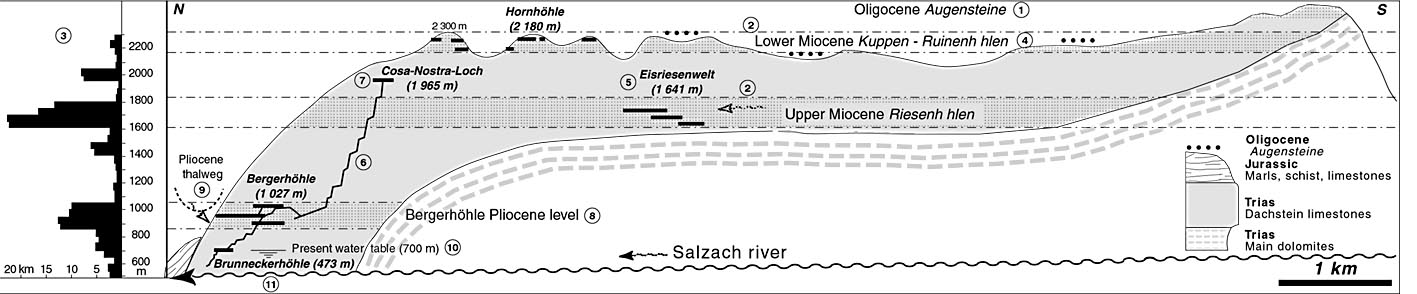
Fig. 2. The Cosa Nostra - Bergerhohle system and the Tennengebirge (see also text). To the left (3), relationship between cave passages altitude and old karst levels (after Klappacher & Knapczyk 1985). Karst development began during the Oligocene beneath Augensteine (1). During the Miocene, horizontal systems developed with alpine water inputs (2), showing different levels (3) related to successive phases of stability: Ruinenhohlen (4) and Riesenhohlen (e.g. Eisriesenwelt - 5). Following Pliocene uplift, alpine systems developed (e.g. Cosa Nostra – Bergerhohle - 6). Entrance horizontal tubes correspond to a Miocene level (7). Shaft series (6) connect to horizontal tubes from Bergerhohle-Bierloch (8), corresponding to Pliocene base level (9). Present water-table at -700 m (10) poors into Brunnecker Cave, which connects to Salzach base level (11).
Augensteine sediments. Hornhohle contains some relatively young flowstones that overlie older flowstone debris broken by neotectonic activity. Most of the older stalagmites are corroded and partly destroyed, bearing witness to their old Miocene age. Fragments are also located at the entrances as well as on the surrounding land surface. This abnormal distribution of the flowstones is proof of slope erosion that intersected the cave. Clastic sediments are represented by homogenous sands, bedded and hardened, consisting of quartz and iron oxides, as well as hardened clays. The latter sometimes contain large gravels consisting of rounded iron-oxide nodules and Augensteine (Fig. 4). These argillaceous, ferrous, quartzose sediments come from the reworking of the weathered superficial rocks (Augensteine).
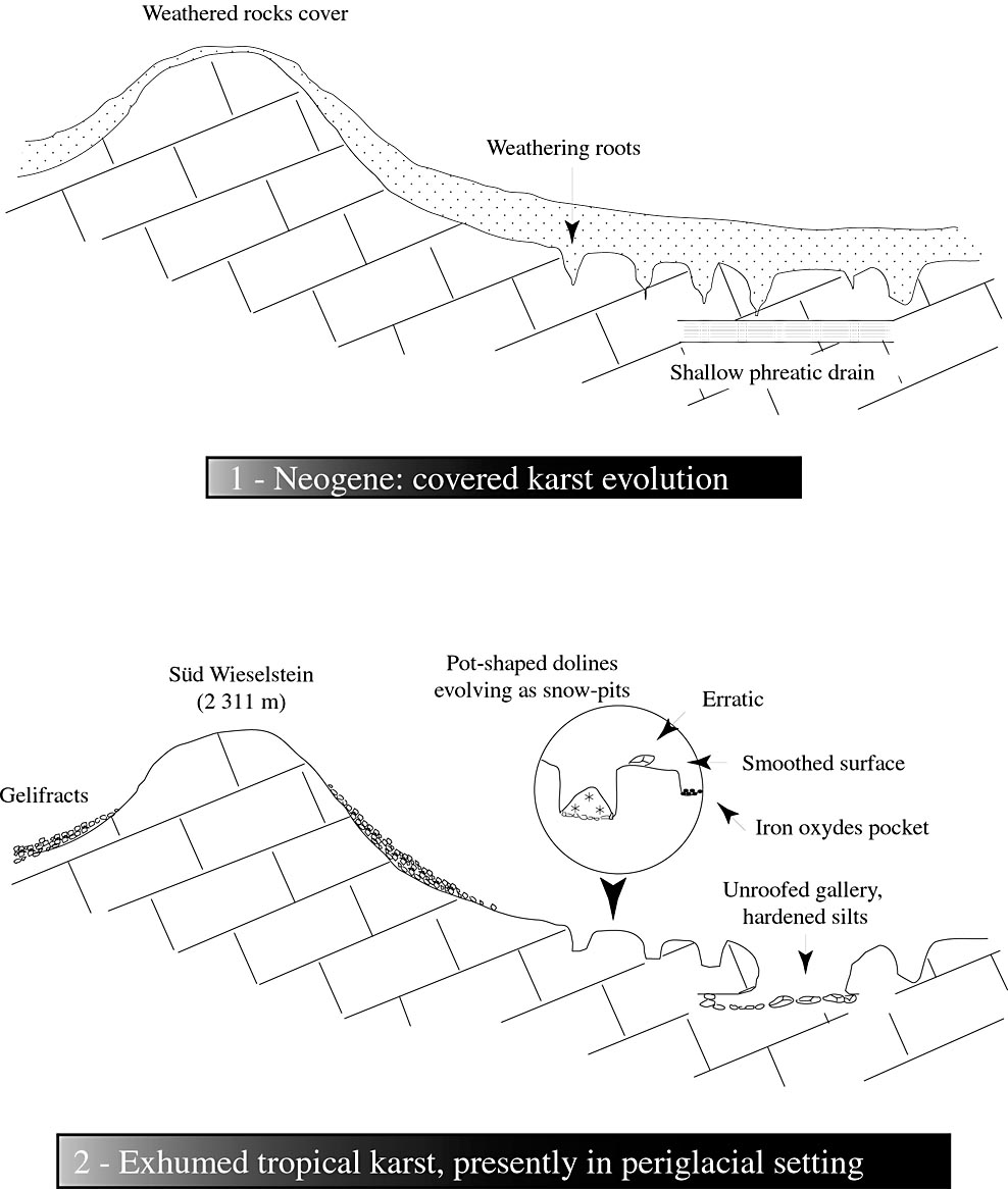
Fig. 3. Diagram showing the evolution of the Windischriedel karst, from the Late Tertiary (top) to the Pleistocene (bottom).
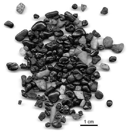
Fig. 4. Reworked weathered rocks, mainly composed of quartz gravels (light) and iron oxides (dark). are sculpted by scallops and the grain-size distribution of the clastic sediments show that these were once partly flooded, with slow current, and developed close to the water table. They are presently perched above current base level.
A major karst level, known as the “Hochkonig level” (Seefeldner, 1961), developed close to a former base level. This evolution was triggered by the partial erosional removal of the Augensteine from the Lower Miocene onward (Tollmann, 1968). At that time the karst had rivers flowing through it from the insoluble igneous and metamorphic rocks in the central Alps. These helped to feed the caves, as well as erode away the sedimentary cover, part of which is still trapped in the caves. This karst was then uplifted up to 2000-2200 m. These tectonic movements, along with Quaternary glaciation, accelerated superficial erosion. In such an unstable environment the sedimentary cover was largely cleared from the surface, with reworked remnants preserved in the cave sediments. Glacial erosion of the karst was limited due to the fact that the area was located close to the crest of the massif. However, some carbonate rock was removed, exposing older caves and transforming the weathered low areas into kettle-shaped dolines, once the infilling of weathered rock was partially removed. The karst is still evolving as a result of periglacial activity (frost and snow action): kettle-shaped dolines act as snow-pits, and bare bedrock is sculpted by karren and covered with debris.
2.2. The Riesenhohlen (“Giant Caves”): the Eisriesenwelt example
The Eisriesenwelt is one of the world's most famous caves. Its underground ice formations extend through nearly one kilometer of a system that is 42 km long, which attracts thousands of tourists every year. It opens onto the western face of the Tennengebirge about half way up the steep cliff that dominates the Salzach Valley (Fig. 2). It is a dry cave consisting of vast sub-horizontal galleries filled with debris. Less common are tubular passages with scallops. The main level, whose initial shape has been obscured by rock debris, varies between altitudes of 1650 and 1750 m. Lateral tubular labyrinths are located in the range of 150 metres both above and below the main cave axis. Links between different levels consist of steeply inclined tubes. A variety of interesting sediments can be found in the talus-floored galleries.
Allogenic fluvial sediments. Clastic sediments carried in by vadose flow are represented by sands and pebbles trapped in potholes (in the Fuchsgang and Gerade Kluft). Fine silts left by phreatic flow are abundant within all the tubular conduits, which they sometimes choke entirely. Sometimes these can form rounded, case-hardened bodies, known as Krapfen (“donuts”). They contain weathered residue from the local limestone and old karst cavities (limestone grains, quartz gravels, and iron oxides). The fluvial sediments composition gives evidence for a more remote origin, as was noticed by early researchers (Lehmann, 1922; Pia, 1923). Their content of quartz, mica, tourmaline, sphene, zircon, garnet, magnetite, and mica schist fragments suggests an input from the metamorphic zones of the central Alps. These sediments are usually rounded as the result of transport by turbulent flow. Relatively recent flowstone is rare but older flowstone is common. Examples of the latter are very large, e.g. stalagmites in the Steinerne Wald (“Petrified Forest”), and thick, partly eroded flowstone floors (Pia, 1923). Many of them consist of transparent calcite, which shows that their growth was under wood covering (Maire, 1990). Their surfaces are commonly corroded by flowing water. Scallops in the dissolved profile of a stalagmite even show the direction of the paleo-current that sculpted it.
An Upper Miocene cave related to fluviokarst. The Eisriesenwelt was fed by sinkholes located between 1650 and 1750 m, which is about 1000 meters above the present Salzach Valley base level. As demonstrated by minerals within detrital sediments, the runoff came from the central Alps. Sediment from the central Alps was carried mainly into poljes where it disappeared into ponors. Large underground rivers developed, similar to those in the tunnel-like caves presently found in tropical climates. Considerable discharge flowed through these galleries, which reach 50 m in width, creating networks with many ramifications. Eroded flowstone and scallops confirm the direction of flow from the central Alps (SE to NW). Steep tubes and looping profiles demonstrate that the conduits were partially flooded and located close to the water table (Audra, 1994; Hauselmann et al, in press). This system evolved during periods when the base level was stable, correlative with low-gradient sections of valley slopes. These comprise the “Gotzen level” and “level I” (Seefeldner, 1961), which developed from the end of the Miocene to the beginning of the Pliocene (Tollmann, 1968). The presence of eroded flowstone shows alternating wet and dry phases. These flowstones, dating from the active period of the Eisreisenwelt, are of Pliocene age, as suggested by Lehmann (1922). The most recent flowstones, which are not eroded, probably date from the lower or middle Pleistocene, during a warm interglacial period (Trimmel, 1992). As uplift continued, the Salzach Valley became entrenched. With the relative lowering of base level, the Eisriesenwelt became perched, drained and intersected by scarp retreat. Neotectonic activity is responsible for the boulder chokes. Thus the Eisriesenwelt is a good example of the Riesenhohlen level of karst development, which is recognized throughout the limestone high Alps (Bauer and Zotl, 1972).
The study of perched caves sediments clarifies the evolution of former karst environments. In Hornhohle, the sediments are linked to the erosional removal of the Augensteine cover at the beginning of the Miocene. In the Eisriesenwelt, the transition to fluviokarst can be demonstrated by the less-weathered sediments, which were carried in by rivers from the central Alps. The mineralogical evolution of the sediments with altitude (and thus with the age of the caves), can also be found in the plateaus of the Hagengebirge and Steinernes Meer, located farther west (Langenscheidt, 1986). Their composition is comparable to that of piedmont sandstones and conglomerates, also dated from the Miocene (Fuchtbauer, 1967; Lemke, 1984; Tollmann, 1968). Each level of karstification includes a link between superficial and deep forms, each of which contains diagnostic sediments. Hornhohle is a Ruinenhohle containing highly weathered sediments, developed in a karst cone in the upper level of the Hochkonig. Lower down, the Eisriesenwelt is a Riesenhohle containing fluvial deposits linked to large poljes. Thus, the surface karst features correspond to the vertical arrangement of caves.

Fig. 5. Cross section of the Cosa Nostra - Bergerhohle System.
2.3. A typical alpine cave-system:
Cosa-Nostra - Bergerhohle
Shafts and dry tubes. The Austrian limestone high Alps are known as much for their large vertical cave systems as for their cave systems with large galleries. The Cosa-Nostra - Bergerhohle System combines these two aspects, giving rise to a vast Pliocene-Pleistocene network, under the joint influence of the last phase of uplift and glaciation. The Cosa-Nostra - Bergerhohle System is located in the northwestern Tennengebirge, extending from 2300 m at the Wieselstein summit all the way down to the Salzach at the Lueg Pass (470 m), the low point of the massif (Figs. 1 and 5). The entrance of the Cosa-Nostra-Loch is at 1965 m, 350 m below the Wieselstein summit. However, other as-yet unconnected shafts extend right up to the high point (e.g. Flohschacht, with a depth of –502 m) and probably constitute the upstream end of the system. Lower down, a dozen linked entrances to the Platteneck ice caves (Platteneck Eishohle), are located between 1400 and 1600 m beneath the Platteneck summit. These two caves are the uppermost entrances to the Cosa-Nostra-Loch - Bergerhohle and are linked to the main part of the system by sub-vertical conduits. Beyond the entrance series, the Cosa-Nostra-Loch consists of a vertical profile known as a “staircase beneath a faulted roof” (Fig. 6). At -600 m, the Riviere des Incorruptibles (“River of the Incorruptables”) appears. The gradient decreases because of the presence of dolomite beds, which are only slightly permeable (Fig. 5). Beyond -1000 m the river can no longer be followed. The conduit, even though a dry tube, has a nearly horizontal profile, which in places is broken by sudden level changes. A kilometer beyond, this passage connects with the
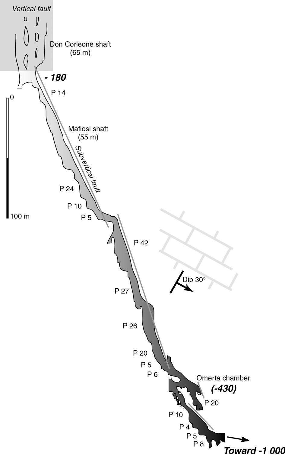
Fig. 6. Profile showing “Stairs beneath a faulted roof” of Cosa-Nostra Loch, a predominant aspect of vertical systems.
Bergerhohle-Bierloch System. This consists of a labyrinth of about 25 km of dry tubes, partly horizontal but containing many vertical sections. A number of streamlets have entrenched the floors of the tubes into steeply sloping canyons interspersed with shafts, which lead to the present phreatic zone at 700-750 m. There are two entrances at this level of horizontal galleries, Bergerhohle and Bierloch, which are located in the glacial hollow below Platteneck summit, at an altitude of about 1000 m. The lowest part of the system is Brunneckerhohle. Its geometry is completely different from that of the Bergerhohle-Bierloch. During periods of high water, the phreatic zone, normally at 700 m at the sump in the Schotter Galerie (“Pebble Gallery”), forms a torrent that pours into a canyon consisting of ramps and cascades that eventually joins the Salzach level. Although the upper and lower parts of the system are still not connected by exploration, the whole system has a vertical range of >1500 m. In all, it contains about 30 km of surveyed passages.
Tertiary and Quaternary sediments. The Cosa-Nostra-Loch contains hardly any sediment. From -1000 m downward, varved carbonate sediments begin to appear that are typical of the Bergerhohle network, covering the cave floor in a thick layer. Some sections include older sediments preserved beneath the varves. There are two successive sequences of sediments (Fig. 7). The lower sequence consists of a variety of pebbles (e.g. in Bierloch). These are overlain by a first generation of large speleothems. The pebbles come from the Jurassic strata overlying the Dachstein limestones. These strata have practically disappeared from the plateau. Their erosion was probably very long ago because there is no evidence of their presence in the sediments of the plateau. Today these strata remain only on the northern flank of the massif several hundred meters below the cave system. The pebbles were rounded by fluvial action before being trapped in the karst, and for this reason they are known as “fake cave pebbles” (Schauberger, 1961). They appear to provide evidence for old waterways draining across the Jurassic beds along the northern part of the massif at about 1000 m altitude, and thus about 500 m above the current level of the Lammer River. This suggests that the water inputs for the initial development of the system could have been allogenic. These high levels of fluvial erosion are apparently Pliocene (Toussaint, 1971). The highly varied grain size of this sediment (clays with cobbles), indicates violent discharges with heavy loads. This suggests a climate with abundant, irregular, and occasionally heavy precipitation. Similar sediments, in the form of pebble conglomerates, which also contain Jurassic components, can be found on the neighbouring Dachstein massif in the Hierlatzhohle (Schauberger, 1983). In the same way, these are linked to former periods of intense surface erosion, combined with torrential subterranean through-flows. The first generation of flowstone after the pebble deposits represents a cessation of stream flow, perhaps as the result of lowering of base level. Their micro-morphology (micrites, alternating with transparent calcite containing fine reddish layers that include considerable clastic material) indicates that they were deposited in an unstable environment, with sparse soil in the process of being removed. The upper sequence consists of varved carbonate sediments locally covered with more recent flowstone. These varved carbonates were deposited in a glacial environment. Thus they correspond to one or more glaciations of the middle or upper Pleistocene. This glacial phase is noted above all for its filling of karst voids at all levels. Even the intercrystalline pores of the ancient weathered flowstones of Bierloch are filled by calcite. Erosion is only superficial, as can clearly be seen on the flowstones in Bergerhohle. In the Hierlatzhohle (Dachstein massif), the glacial varves reach 5 m in thickness in the Lehmtunnel (“Clay Tunnel”), at an altitude close to those of Bergerhohle (Schauberger, 1983). This study noticed a black film covering the varves in Hierlatzhohle, in the Schwartzhalle and Schwartzgang (“Black Hall” and “Black Passage”), and in the Dachstein-Mammuthohle, which gives a dull and sinister look. This can also underground soot deposited after a huge fire that ravaged the Dachstein massif during the Atlantic interval (about 4.5-7.5 ka), when the forest was widespread on all the high plateaus. However, the presence of this film in other areas undermines this unconvincing hypothesis. The film is probably simply due to superficial oxidation in contact with air. The end of the upper sequence has sparse speleothems, with some still active in the lower wooded areas of the karst above the Bierloch - Brunnecker System. These speleothems give evidence for a return to a biostatic environment (development of thick soils during a period of tectonic stability, when biotic activity was at a maximum).

Fig. 7. Generalized stratigraphic section of the sediments in the Bergerhohle and Bierloch system. Black circles = normal paleomagnetic orientation; white circles = reversed paleomagnetism.
Several samples have been dated. Paleomagnetism has been applied to stalagmites, flowstones and varves. The natural remnant magnetizations (NRM) were measured with a rotating remanometer (JR5A Spinner Magnetometer) during demagnetization in an increasing alternating field (AF), up to 100 mT (Table 1). The measured intensity in flowstones was weak, which raised some difficulties in interpreting the results, as intensity became too low. However, varves show a strong magnetic intensity. Samples BR 4, BR 5, BH 4 (Fig. 8) have strong directional stability during demagnetization with characteristic directions showing normal polarities pointing toward deposition in the Brunhes period (<780 ka). Samples BH 2, BH 3 (Fig. 8) have a poorly defined behavior due to low intensity, nevertheless their direction seems to show reverse polarities that could be related to Matuyama period (>780 ka), but these values are not completely reliable. Varves show a horizontal inclination, linked to sedimentation mechanisms. Magnetic anisotropic susceptibility measurements from BH 4 and BR 5 samples do not show any preferential axis, sedimentation occurring by decantation, without any current. This also proves primary magnetizations, acquired during sediment deposition (Audra and Rochette, 1993).
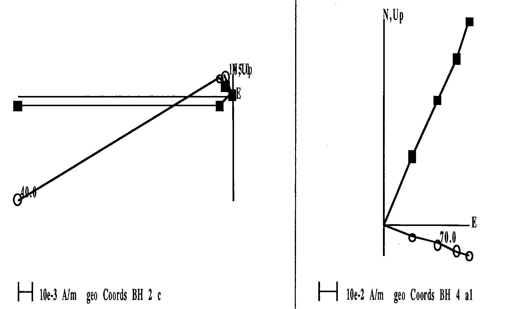
Fig. 8. Orthogonal Zijderveld plots showing the NRM vector evolution during AF demagnetization up to 100 mT (BH 2, BH 4 samples).
TABLE 1.
Paleomagnetic results. Specimen NRM intensity, characteristic directions obtained from AF demagnetization, magnetostratigraphic interpretation.
Sample |
Sediment type |
NRM Int. (mA/m) |
Decl. (°) |
Incl. (°) |
Polarity |
Age (ka) |
|
3 BR5 a |
Stalagmite Brunnecker |
0,001 |
342 |
59 |
Normal |
< 780 ka |
|
3 BR5 b |
0,002 |
340 |
55 |
Normal |
< 780 ka |
|
|
3 BR5 c |
0,002 |
342 |
60 |
Normal |
< 780 ka |
|
|
1 BR5 |
Varves Brunnecker |
0,02 |
12 |
0 |
Normal |
< 780 ka |
|
2 BR5 |
9,5 |
334 |
4 |
Normal |
< 780 ka |
|
|
BR4 |
Stalagmite Bru. |
0,4 |
340 |
68 |
Normal |
< 780 ka |
|
BH4 a1 |
Varves Bergerhöhle |
11 |
21 |
12 |
Normal |
< 780 ka |
|
BH4 b1 |
11 |
28 |
12 |
Normal |
< 780 ka |
|
|
BH4 a2 |
11 |
22 |
12 |
Normal |
< 780 ka |
|
|
BH4 b2 |
13 |
29 |
18 |
Normal |
< 780 ka |
|
|
BH2 a |
Flowstone floor Bergerhöhle |
0,1 |
94 |
-75 |
Reverse |
> 780 ka |
|
BH2 b |
0,2 |
176 |
-59 |
Reverse |
> 780 ka |
|
|
BH2 c |
0,3 |
176 |
-59 |
Reverse |
> 780 ka |
|
|
BH3 a |
Stalagmite Bergerhöhle |
0,02 |
131 |
- 50 |
Reverse? |
> 780 ka? |
|
BH3 b |
0,02 |
194 |
-73 |
Reverse? |
> 780 ka? |
|
|
BH3 c |
0,008 |
148 |
-47 |
Reverse? |
> 780 ka? |
TABLE 2
Geochemical data and sample radiometric age.
|
Sample |
[U]ppm |
234U / 238U |
230Th / 234U |
230Th / 232Th |
234U / 238U t = 0 |
Age (ka) |
|
BL 2 |
0,038 (± 0,002) |
1,254 (± 0,072) |
0,795 (± 0,043) |
4,8 (± 0,4) |
1,395 |
157,3 (+ 23,5 / -18,5) |
|
BR 2 |
0,228 (± 0,012) |
1,357 (± 0,073) |
0,047 (± 0,007) |
2,2 (± 0,6) |
1,362 |
5,2 (+ 0,9 / - 0,8) |
Two speleothems were dated using U-series (alpha-counting). The weak 230Th / 232Th ratio might show a contaminated system opening, so calculated ages are unreliable (Table 2). However, BR 2 Holocene age is quite certain and concords with sediments stratigraphy. For BL 2, calculated age corresponds to isotopic stage 6, the early beginning of last glacial stage “Riss”. A low probability of speleothem development in a glacial context, indications of system opening and incoherence with sediments stratigraphy that suggest an older age, hence this date can not be taken at face value.
These data show the difficulties in establishing long-term chronology in karst environment, linked firstly to the lack of widespread dating methods for the ancient periods and secondly by stratigraphic discontinuities that often hinder correlations. Nevertheless, these initial datings of an Austrian cave system give evidence for two distinct periods (Fig. 2).
• Bergerhohle-Bierloch lower sequence old age is confirmed, its upper part corresponding to flowstones showing signs of reverse polarities, older than 780 ka. Paleomagnetic data is compatible with an early Pleistocene or Pliocene age. The conduits located at a passage level controlled by local runoff, probably allogenic. Lowering of base level interrupted this process, allowing extensive calcite deposition to take place. All of this occurred in an unstable environment with extremely violent high waters, corresponding alternatively with either surface erosion bringing clays or the regrowth of woodland cover giving rise to calcite deposition. This stage can be linked both to the progressive cooling of the climate, as well as to continued uplift of the massif. Additional research is necessary to confirm this hypothesis.
• Interpretation of the second depositional period is based on more solid evidence. Brunnecker Pleistocene upper sequence seems to have developed during a recent normal period, being younger than 780 ka. It is still difficult to attribute its origin to one or more identified glaciations, and to precisely identify the Salzach valley entrenchment steps. Advancing glaciers reactivated the deep karst, causing repeated flooding to heights of >600 m, partially choking the conduits with sediment. After this phase, the system drained and speleothems developed. However, the correlation of late Tertiary karst phases is not clear on a regional scale. This cave system has revealed its potential; the fairly similar layout of Pliocene-Quaternary cave systems of the high limestone Alps makes it possible to compare them and gives solid evidence for this evolutionary model. An accurate chronology, based on a detailed stratigraphy combined with dating, would be of interest.
3. Parameters determining the current morphology and hydrology
3.1. Conduit Morphology in vadose systems
Parameters that determine the pattern of vadose conduits. A study of all kinds of vadose conduits leads to a model that incorporates 3 parameters: slope, jointing, and discharge (Fig. 9). The origin of a meander involves a number of factors. Jointing must be moderate (Fig. 9/1). If the slope is gentle, sinuous meanders will evolve into an angular system of joint-controlled pseudo-meanders (Fig. 9/2). If the slope is steep, shafts will dominate by capturing the runoff (Fig. 9/3). In addition, the discharge must remain moderate. Otherwise the conduits widen and become rather straight canyons. Depending on the amplitude of the initial floods, the original tubes will either be hardly affected or will alternatively form a “keyhole.” In the Tennengebirge, meanders are rare because of intense jointing and steep conduit gradients. Canyons (in the context of this paper) are underground galleries higher than they are wide, with abrupt rock walls entirely dissolved in limestone. Their main characteristic is their size, which is several meters wide and several dozens of meters to >100 meters high. This type of canyon is generally not sinuous. The condition necessary for the establishment of such a canyon is great discharge (several hundreds of L/sec to several m3/sec). These flows can move large clasts, such as cobbles several decimetres in diameter, as seen at Brunnecker. If the overall slope is small (Fig. 9/4), then the canyon will consist of a series of basins with channels linking them (e.g. Skocjan Cave in Slovenia). With increasing slope, small potholes appear.
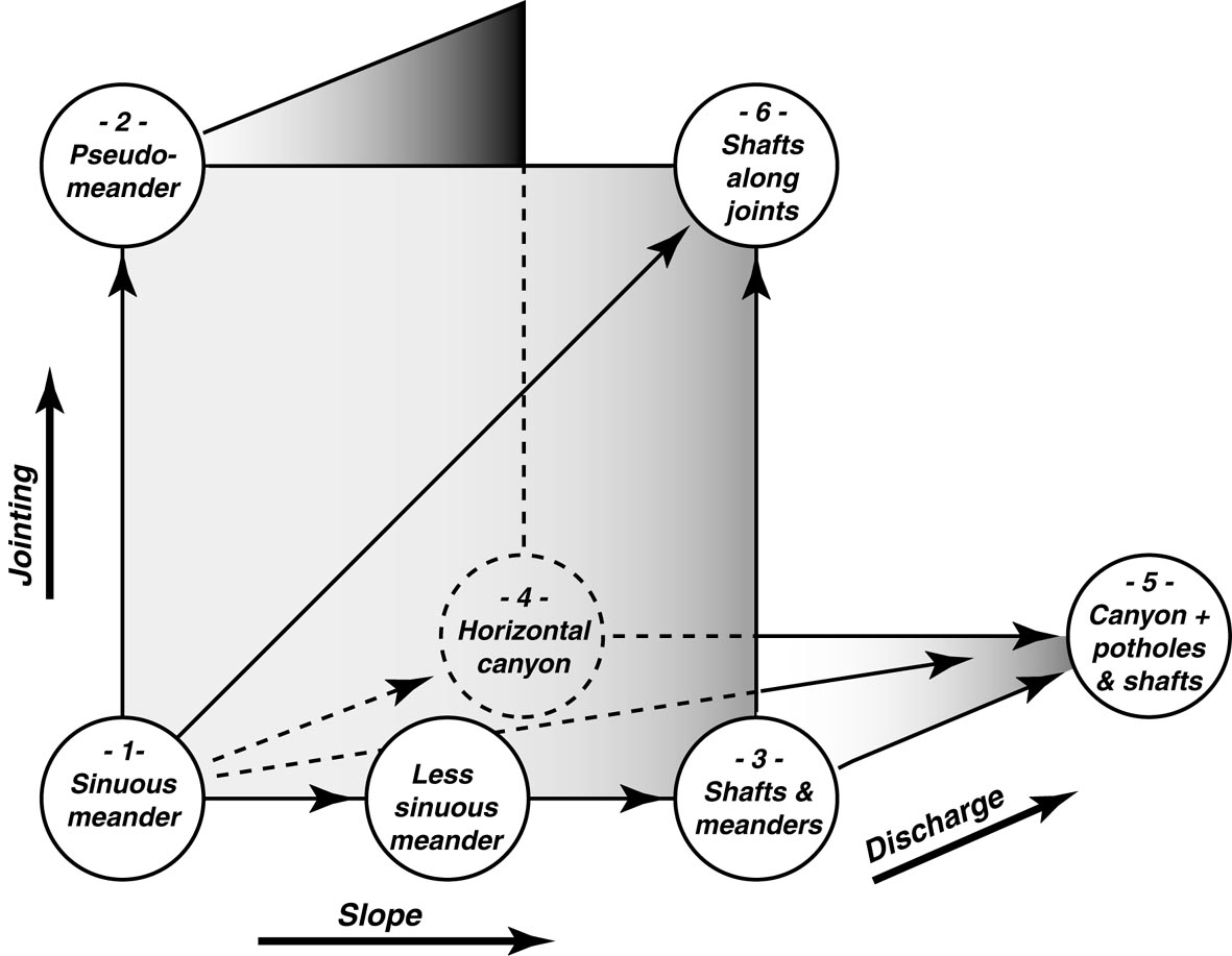
Fig. 9. Predominant conduits in the vadose zone, in relation to slope, jointing, and discharge.
At the foot of each vertical drop, mechanical erosion will form potholes with the aid of suspended pebbles (Fig. 9/5). This is the classic morphology of tropical mountains, where high-relief shafts are fed by inputs from large perched basins (e.g Mexico and China; Zhang et al, 1991). Brunnecker includes a canyon that consists of a series of inclined ramps interspersed with cascades of pits and potholes, where the high-water discharge can reach several cubic metres per second. For there to be shafts there must be sufficient topographic potential. In most places, vertical routes are developed along joints, which enable rapid penetration of the limestone layers (Fig. 9/6). Thus, the large vertical systems, with successions of pits, are more likely in highly jointed carbonate rocks. The Austrian limestone high Alps have all these characteristics, and the large vertical shafts are a common feature particular to this area (some being >400 m deep). The intersection of a vertical fault and an inclined fault of 70 or 80° is typically responsible for the “staircase beneath a faulted roof” (Fig. 6). The inclined fault provides a steeply sloping roof, which guides the conduit. Beneath this fault roof a succession of pits develops, each pit separated by narrow windows, forming a giant stairway that can extend over a vertical range of several hundred metres.
Jointing and vertical cross-sectional shape of the systems. As with detailed conduit morphology, jointing is a determining factor in the organization of vadose networks. Two kinds of vadose networks can be distinguished, depending on how well they are adapted to the geologic structure. Where jointing is moderate, conduits have a gentle slope, with meandering canyons predominating over shafts (Fig. 10, top). These conduits have many high-order tributaries and are fed by large drainage basins. The whole network has a slightly concave-upward profile. This makeup is common in gently sloping plateau karst (such as in the Vercors of France). On the other hand, where jointing and topographic potential are very strong, as in massifs with overthrusts, it is typical to have shaft series with a steep descent to the horizontal conduits (Fig. 10, bottom). Each one drains a relatively small basin, in places less than one hectare. The result is a great number of catchments, each with small discharge, leading to the low-gradient conduit system with only a very slight hierarchical arrangement. The whole network has a very concave-upward profile. These are common in the Austrian high alpine karsts.
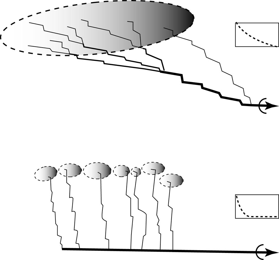
Fig. 10. Morphology of passage in relation to jointing intensity. Above, with little jointing, profile is slightly concave and strongly hierarchical (e.g. Vercors). Below, in highly jointed rock, profile is strongly concave and only slightly hierarchical (e.g. Tennengebirge).
3.2. A dammed karst
Karst drainage is determined by several parameters, such as structure of the karst aquifer, position of base level, and duration and phases of karst development. The great homogeneity of the Tennengebirge strata provides no significant differences on scale of the entire massif. The base-level position, having continually dropped since the late Tertiary, is a determining factor in the evolution of the karst and the nature of the runoff. The vertical speleogenetic potential, presently more than 1500 m, was developed before the Pleistocene, thus all of the major cave systems were developed before the Pleistocene. All of these variables determine the organization of underground circulation in the northwestern Tennengebirge, including that of the Cosa-Nostra - Bergerhohle system.
The vadose zone. The vadose zone is typified by large shaft systems. As in all high mountain karsts, discharge is highly variable, and peak flows are very powerful. Intense jointing allows the drainage area to be partitioned into many small basins of several hectares each. Thus it is not uncommon for two neighbouring shafts to penetrate deep into the limestone without interconnecting. In the Cosa-Nostra-Loch, the River of the Incorruptibles enters at -600 m and then leaves the passage again at -1073 m. Most of the runoff comes from the Wieselstein area. Its discharge can vary from a few liters to hundreds of liters per second. This water feeds the phreatic zone beneath the Bergerhohle-Bierloch system at about 700 to 750 meters altitude.
The phreatic zone.The phreatic zone, whose top is at an elevation of about 700 m, drains most of the northwestern part of the Tennengebirge. The known tributaries come from the Wieselstein (Cosa-Nostra-Loch), Platteneck and from the area above Bierloch. The latter passages are captured by the large N-S Bierloch fault, which during low water acts as a drain toward the north and as a low-permeability dam to water from the east. This phreatic zone originates from the Jurassic beds of marly schist, which have been preserved from erosion at the northern foot of the massif (Fig. 11). These act as a dam for water in the Dachstein Limestone aquifer. Outlets are located at low points in the geologic structure, which correspond to areas where the Jurassic layers have been eroded the most. The geological map shows these hollows to be located at the foot of glacial valleys (e.g. Winnerfall Spring), or at the outlet of the Salzach Gorge (Klappacher and Tichy, 1986). Glaciers seem to have produced the localized erosion that determined these emergence points, and as a result they have controlled the organization of the entire phreatic zone. According to Toussaint (1971), this level of 700 m, which is clearly marked by horizontal galleries and levels of springs, corresponds to a former static base level. This would correspond to the “level V”, dating from the Lower Pleistocene. Its development is linked to glacial activity, which supports the idea of evolution during this period. The only place where this structural dam has completely disappeared is at the level of the Salzach Gorge, where the erosional power of the glacier was much greater, and where the plunging saddle of Dachstein limestone is dissected by the valley. As a result, this potential outlet of the aquifer below 500 m altitude has led to the development of the Brunnecker Cave System, which forms a link between the 700-meter-high phreatic zone and the present Salzach base level. During low water, low discharge occurs (Fig. 12, top). The entire phreatic zone seems to be drained by the Kuchl Creek Spring (Kuchlbachquelle), which emerges at 670 m altitude in the Infang Meadows (Infangalm), through the slightly karstified Jurassic beds. Their weak transmissivity is enough, however, to transmit moderate discharges. Thus, the “lithological dam” is only a relative concept.
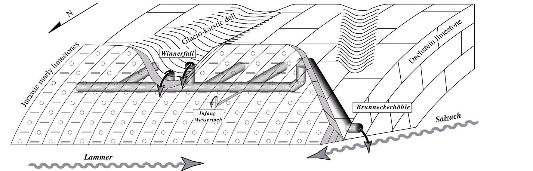
Fig. 11. Impermeable Jurassic strata dam the Dachstein Limestone aquifer (not to scale). Spring outlets are located at structural lows where glaciers have eroded the Jurassic beds.
The epiphreatic zone. The level and amplitude of the epiphreatic zone fluctuates seasonally according to the amount of runoff. During high water resulting from storms or snow melt, the input can be 100 or even 1000 times greater than its usual flow, to the point that runoff from many sources reaches the water table more or less simultaneously (Fig. 12, bottom). The Kuchlbach Spring is unable to handle such a large input, even when its overflow outlet, the Infang Wasserloch, becomes active. As a result, the top of the phreatic zone in the aquifer rises several tens of meters, for example about 50 m for Bierloch and the Winnerfall. This rise activates higher-level springs with great discharges. One of these outlets, located about 80 m deep in the Bierloch phreatic zone, bypasses the damming influence of the Bierloch fault, discharging several cubic meters per second into the Brunnecker sump. This runoff pours into the Brunnecker canyon, filling the bottom of the cave system, resulting in flooding to depths up to 50 m. In July 1991, after 10 days of heavy rainfall, the Brunnecker spring discharge was about 5 m3/sec. Similarly, farther east, following a 50-meter-high flood, the Winnerfall Spring became active. However large these floodings in the epiphreatic zone may seem, at no time do they reach the 600 m mark, which is the level reached during Pleistocene glacial phases.
The emergences. The phreatic zone drains through a series of outlets, of which the main ones are (from east to west) the Dachserfall, Tricklfall and Winnerfall. These are the three largest springs in the massif (Fig. 1). Directly connected to the phreatic zone, these are located at about 700 m altitude and are perched about 150 m above the low parts of the Lammer valley. The average discharge is several hundreds of L/sec. The Brunneckerhohle, located at the Salzach level (500 m), has grown by capturing the phreatic zone at 700 m, which still remains perched above the cave (Fig. 11). This phreatic zone extends along the northern edge of the massif. It has an unusual drainage pattern. As the inflowing vadose water arrives, these infeeders do not have a preferential direction but instead diverge toward the springs, some of which are far apart from each other. Dye introduced in the Western part emerged from both Winnerfall and Brunnecker (Toussaint, 1971; Fig. 1). Thus the behavior of the phreatic zone depends on the hydraulic conditions. At low water, the drainage is oriented along a south-to-north axis, and the phreatic water is able to drain through the structural dam. In contrast, during high water the structural dam serves as a significant choke, and so the bulk of the discharge is oriented east-to-west, where it escapes by overtopping the structural dam. The runoff then uses better-organised drains at a higher level, which are more capable of evacuating the water.
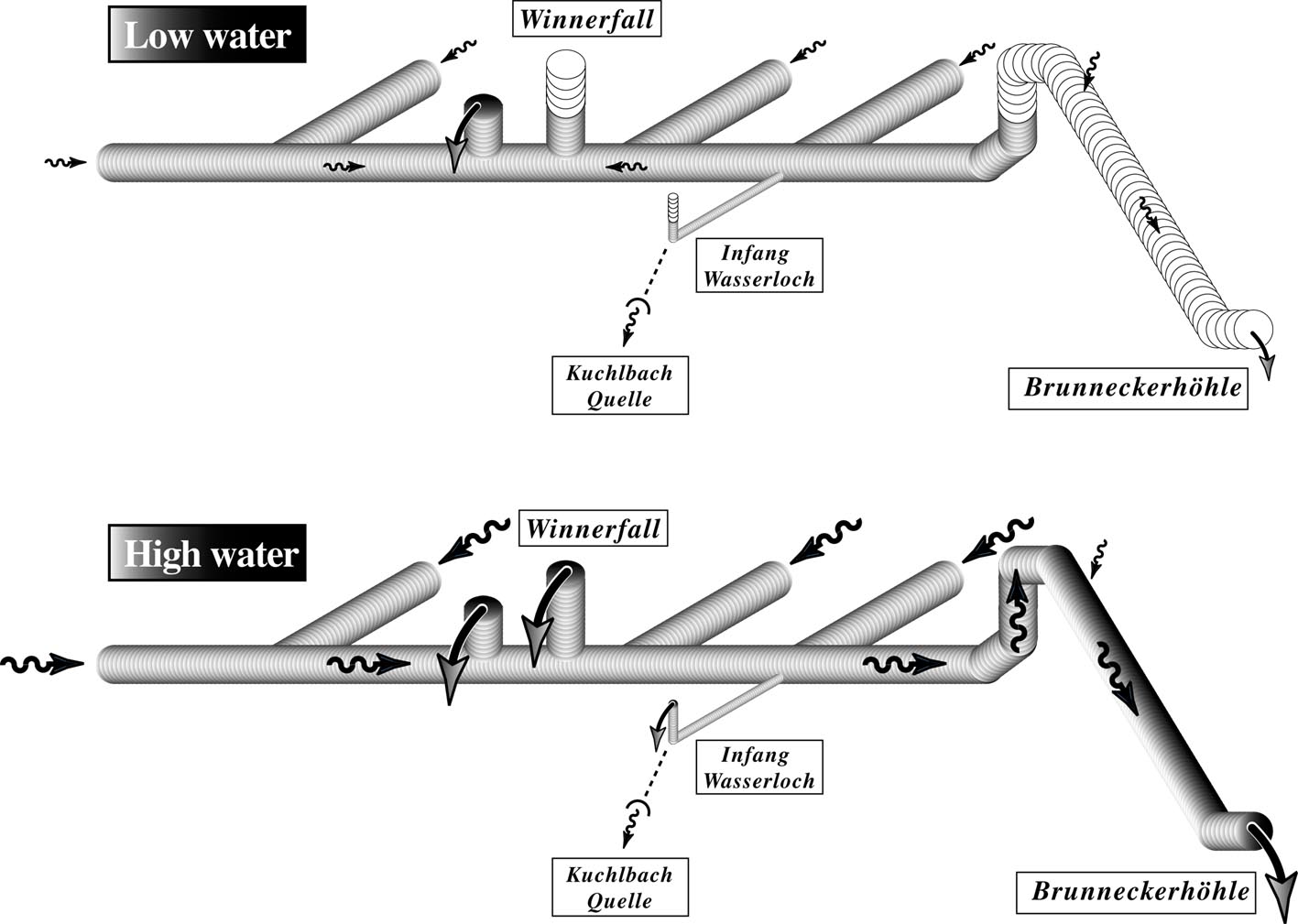
Fig. 12. Nature and direction of the high water (top) and low water (bottom) flow in the 700 m phreatic zone.
4. The karst sediments: paleoclimatic and hydrodynamic markers
The deep karst is an environment well suited to preservation. It harbors old sediments that are no longer at the surface because of erosion. Their study is of prime importance to the understanding of karst genesis and paleoclimates (Audra, 1995).
4.1. Typical sediments of hot or temperate environments
Reworked weathered rocks. During the Tertiary, the warm, wet climates were responsible for intense chemical erosion of the rocks that produced the clastic covers of the Augensteine, the thick residuum of weathered rocks that were reworked and transported into the karst (Fig. 4). These reworked weathered rocks are mainly made up of Augensteine, clays, and iron oxides (Weingartner, 1983). These make up the oldest deposits in the studied caves, some being certainly linked to the first phases of the cave development. The weathered rocks were trapped in the cavities after the removal of the surficial cover. This erosion was linked to the change of precipitation patterns in the late Tertiary, as well as the climatic degradation at the end of the Pliocene. In any case, this climatically induced erosion was enhanced by tectonic uplift. The clearing of these covers, followed by their trapping in the inside of the karst, seems to be a common characteristic of the Pliocene-Quaternary evolution of temperate mountain karsts (Fernandez Gibert et al, 1994; Maire, 1990).
Speleothems of warm or temperate periods. The growth of flowstone is a function of vegetation cover, and thus of climate (Quinif, 1992). As a result, speleothems do not normally develop in high alpine karst areas. Their complete absence in the Cosa-Nostra-Loch is considered evidence for a cold mountainous environment. In contrast, flowstone developed in the nearby perched horizontal galleries of late Tertiary age, such as Hornhohle, indicating warm paleoclimates. Today speleothems are able to form at lower altitudes as soon as there is a vegetation cover (e.g. Bierloch and Brunnecker caves; Table 2). The crystalline fabric of the flowstone gives indications of the environment of deposition (Maire, 1990). Transparent calcite indicates growth within a biostatic environment, with thick vegetation cover that blocks the descent of clastic sediment into deep openings and promotes supersaturation of infiltrating water, causing rapid speleothem growth. This was especially true for the first-generation speleothems of Bergerhohle and Eisriesenwelt, of both Miocene and Pliocene age. These characteristics can also indicate age, because such biostatic conditions have not existed in these mountains for a considerable length of time. Conversely, red and brown impurities and a succession of micro-layers indicate deposition in an unstable environment, when detrital material was carried in from overlying soil, with numerous interruptions of calcite deposition. This sudden acceleration of geomorphic processes, shown by the flowstones in old Tennengebirge cavities, appears to correlate with droughts, as was often the case during the late Tertiary, or periods of widespread cooling, as occurred several times during the Plio-Pleistocene. The flowstone surfaces also recorded events following their development. An eroded surface means that the cave has been reactivated by increased discharge following calcite deposition. Most flowstones in Tertiary caves contain such features, indicating complex climatic cycles during the late Tertiary or due to Pleistocene glaciation.
4.2. Glacio-karstic sediments
Carbonate-rich varves in the epiphreatic zone. Glacial abrasion of the limestone massifs pulls off rock particles, which are then brought underground by sub-glacial streams. These particles are composed of calcite flakes (amounting to a total of 35-62% CaCO3) as well as angular quartz grains. Seasonal glacial melting releases large amounts of runoff that overwhelms the underground systems, causing them to flood to heights of several hundred meters. The calcite particles are transported in a “uniform suspension” (Riviere, 1977) that extends throughout the flooded conduits. Later the runoff decants during the slow winter draining of the system. The resulting sediments form alternating light and dark laminae that correspond to the successive hydrologic phases. Thus, these seasonal lacustrine deposits of glacial origin can be considered varves (Maire, 1990), which give unquestionable evidence for past glaciation . In the absence of current and with calcite supersaturation, the erosive capacity of the meltwater in the epiphreatic and phreatic zones is very weak. Their speleogenetic effect is mainly to seal the cave systems. There is much evidence for their inability to enlarge caves, such as the preservation of older flowstones, whose surfaces are slightly smoothed. Therefore, this suggests that these deep networks are in many case pre-glacial and that they have been affected by a variety of runoff and environmental conditions (Bini et al., 1998).
Coarse glacial deposits in the vadose zone. Vadose conduits close to glacial meltwater streams contain easily identifiable fluvio-glacial sediments derived from the erosion of moraines. Their varied petrography consists of numerous crystalline and metamorphic phases carried in from high alpine areas by valley glaciers. These subterranean streams are very competent and can transport cobbles several dozens of centimeters in length, for example at Brunnecker spring (Fig. 13).
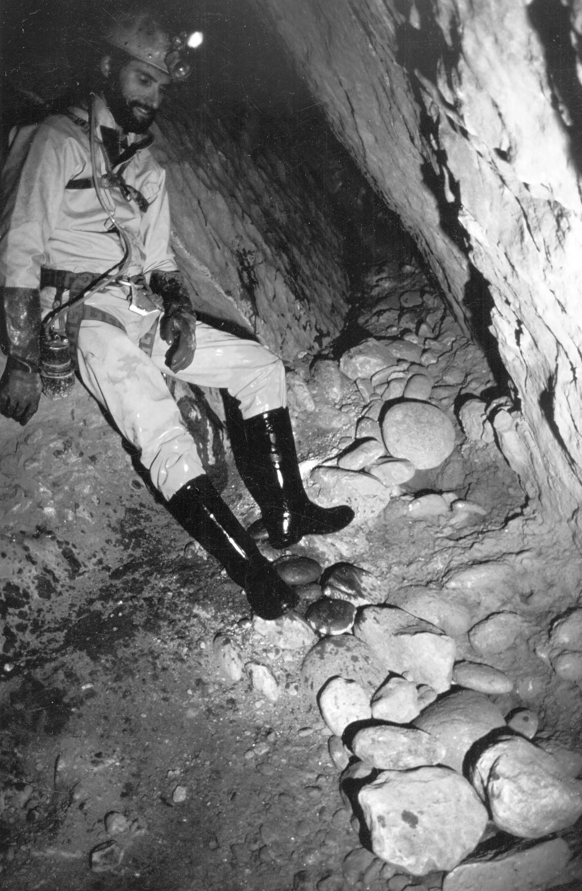
Fig. 13. Wassergang (“Water gallery”) in Brunneckerhohle, showing deposits of allogenic moraine-derived pebbles. (Photograph by S. Caillault.)
5. Conclusion: evolution and genesis of the Tennengebirge karst
The Tennengebirge is distinguished by its great limestone thickness and steep local dips. Due to this thickness, along with alternating periods of uplift and stability, the massif retains a very clear record of all the different karst stages, exemplified by distinct passage levels (Fig. 2). This evidence will benefit future research on this subject, especially as more dates are obtained on deposits. Despite their altitude, the glacio-karstic features are very widespread, and their long evolution dating from the end of the Paleogene has left a strong geomorphic evidence for their Tertiary heritage. The karst is strongly linked with allogenic inputs, including:
- a widespread fluviokarst during the Miocene,
- a fluviokarst limited to the northern slope during the Pliocene,
- a Quaternary glacio-karst, fed by allogenic glaciers, which also blocked the outlets of deep cave systems.
The contribution of these external factors, especially the major allogenic water inputs, is the main explanation for the large size of the cave systems. Similar characteristics are well developed in the northern pre-Alpine massifs of France (Audra, 1994). During this long developmental history, the hydrologic function of the karst depended on variations in the nature of the water inputs. High-water periods can be linked to “tropical” precipitation patterns or glacial melting. Concentrated infiltration during these brief periods caused sediment chokes and reactivation of higher-level passages and perched drains (Audra, 1997). This sort of coincident activation of drains is still quite apparent today. Thus, not only does the Tennengebirge have all the characteristics of high alpine karst, but it also contains evidence for a long karstic evolution, which many other more relatively recent evolved alpine massifs do not have. For example, the Tennengebirge contrasts with certain massifs of Savoy (France) and Switzerland, where the exposure of carbonates by erosion of their insoluble cover has occurred much more recently (Maire, 1990).
Acknowledgement
I would like to thank P. Wilson for the translation of this article, and A. N. Palmer and the two anonymous reviewers for their helpful comments.
References
- Audra, Ph. 1994. Karsts alpins. Genese de grands reseaux souterrains. Exemples: le Tennengebirge (Autriche), l’Ile de Cremieu, la Chartreuse et le Vercors (France) [Alpine karsts. Genesis of large cave systems]. Thesis. Grenoble 1 University, France. Karstologia Memoires (5), 280 p.
- Audra, Ph. 1995. Signification des remplissages des karsts de montagne [Signification of mountain karst infillings]. Karstologia (25), 13-20.
- Audra, Ph. 1997. Le role de la zone epinoyee dans la speleogenese [The epiphreatic zone part in the speleogenesis]. Proceedings of the 12th International Congress of Speleology, La-Chaux-de-Fond. International Union of Speleology / Swiss Speleological Union, la Chaux-de-Fonds. Vol. 1, 165-167.
- Audra, Ph. and Rochette P. 1993. Premieres traces de glaciations du Pleistocene inferieur dans le massif des Alpes. Datation par paleomagnetisme de remplissages a la grotte Vallier (Vercors, Isere, France) [First traces of lower Pleistocene glaciations in the alpine massif. Datation by paleomagnetism of the fillings in the Vallier cave (Vercors, Isere, France)]. Compte-rendu a l’Academie des sciences, S. 2, 317, (11), 1403-1409. Academie des sciences, Paris.
- Bauer, Fr. and Zotl J. 1972. Karst of Austria. In: Herak, M. and Stringfield (Ed.), Karst, the important karst regions of the Northern Hemisphere. Amsterdam, Elsevier, 225-265.
Bini, A., Tognini, P. and Zuccoli, L. 1998. Rapport entre karst et glaciers durant les glaciations dans les vallees prealpines du Sud des Alpes [Karst and glaciations in the Southern pre-alpine valleys]. Karstologia (32) 7-26. - Fernandez Gibert, E., Palomares, M., Rossi, C. and Tortosa, A. 1994. Analisis de procedendia en arenas karsticas: evidencia de una cobertera permotriasica erosionada en el macizo occidental de Picos de Europa [The origin of karst sands: evidence of Permo-Triassic cover erosion in Western Picos de Europa massif]. Actas del 1 congreso internacional sobre Picos de Europa, Oviedo 1991. Asturian Speleological Federation, Oviedo, 1-14.
- Fuchtbauer, H. 1967. Die Sandsteine in der Molasse nordlich der Alpen [Molasse sandstones in the Northern Alps]. Geologische Rundschau (56) 266-300.
Goldberger, J. 1951. Reste abgetragener Hohlen auf dem Hochkonig [Relics of eroded caves in Hochkonig]. Die Hohle (1) 9-11. - Goldberger, J. 1955. Die Altlandschaft auf dem Hochkonig [Inherited landscapes in Hochkonig]. Mitteilungen der Osterreichischen Geographischen Gesellschaft (97) 183-191.
Hauselmann, Ph., Jeannin, P.-Y. and Monbaron, M. Genesis of caves - a new, comprehensive model. Zeitschrift fur Geomorphologie (submitted paper). - Haseke-Knapczyk, H. 1989. Der Untersberg bei Salzburg [The Untersberg near Salzburg]. Doctoral Thesis University of Innsbruck, Wagner. 224 p.
- Klappacher, W. and Knapczyk, H. 1985. Salzburger Hohlenbuch [Salzburg’s caves book]. Vol. 4 (Tennengebirge). Landesverein fur Hohlenkunde, Salzbourg, 557 p.
- Klappacher, W. and Tichy, G. 1986. Geologische Karte des Tennengebirges [Tennengebirge geological map]. Salzburger Hohlenbuch. Vol. 4 (Planbeilagen). Landesverein fur Hohlenkunde, Salzbourg.
- Langenscheidt, E. 1986. Hohlen und ihre Sedimente in den Berchtesgadener Alpen [Caves and their sediments in the Berchtesgaden Alps]. Forschungsbericht (10). Berchtesgaden National Parc, 95 p.
- Lechner, J. 1949. Neue karst - und quellengeologische Forschungen im Toten Gebirge [New karstic and hydrogeologic researches in Totes Gebirge]. 3. Vollversammlung der Bundeshohlenkommission. Vienna, 32-38.
- Lehmann, O. 1922. Die grosse Eishohle im Tennengebirge (Salzburg). (Eisriesenwelt) [The large ice-cave in Tennengebirge (Salzburg). (Eisriesenwelt)]. Spelaologisches Jahrbuch (2), 52-121.
- Lemke, K. 1984. Geologische Vorgange in den Alpen ab Obereozan im Spiegel vor allem der deutschen Molasse [Geological conditions in the Alps from Upper Miocene compared to the german molasse]. Geologische Rundschau (1), 371-398.
- Maire, R. 1990. La haute montagne calcaire [The calcareous high mountain]. Karstologia Memoires (3). Thesis Nice University. 731 p.
- Pia, J. 1923. Die gro?e Eishohle im Tennengebirge (Salzburg), (Eisriesenwelt). Geologische Beobachtungen [The large ice-cave in Tennengebirge (Salzburg). (Eisriesenwelt). Geological observations]. Spelaologisches Jahrbuch (2), 48-65.
- Quinif, Y. 1992. L'apport des methodes de datation absolue: la methode Uranium / Thorium [Contribution of absolute dating methods: the U/Th series method]. In: Speleo-club de Paris (Ed.): Journees Pierre Chevalier, Grenoble, 248-260.
- Riviere, A. 1977. Methode granulometrique. Techniques et interpretations [Granulometric method. Technic and interpretations]. Masson, Paris. 167 p.
- Schauberger, 0. 1961. Uber falsche Hohlenschotter [The fake cave pebbles]. Die Hohle (12) 12-14.
- Schauberger, O. 1983. Geologische und morphologische Beobachtungen in der Hierlatzhohle (Dachstein) [Geologic and morphologic observations in Hierlatzhohle cave (Dachstein)]. Schiftenreihe des Heimatmuseums, “Ausserland” (4) 1-21.
- Seefeldner, E. 1961. Salzburg und seine Landschaften: eine geographische Landeskunde [Salzburg and its landscapes: a geographic contribution]. Bergland-Verlag, Salzbourg . 573 p.
- Tichy, G. 1985. Geologische Ubersicht [Geological overview]. In: Klappacher, W. and Knapczyk, H. (Ed.): Salzburger Hohlenbuch. Vol. 4 (Tennengebirge). Landesverein fur Hohlenkunde, Salzbourg, 27-45.
- Tollmann, A. 1968. Die palaogeographische, palaomorphologische und morphologische Entwicklung der Ostalpen [Paleogeogaphy, palaeomorphology and morphologic evolution of the Eastern Alps]. Mitteilungen der Osterreichischen Geographischen Gesellschaft (I-II), 224-244.
- Toussaint, B. 1971. Hydrogeologie und Karstgenese des Tennengebirges (Salzburger Kalkalpen) [Hydrogeology and karst genesis of the Tennengebirge (Salzburg calcareous Alps]. Steirische Beitrage zur Hydrogeologie (23), 5-115.
- Trimmel, H. 1992. Quelques remarques sur le developpement des grottes des Alpes orientales au Pleistocene et a l’Holocene [Some remarks about Eastern Alps cave evolution from Pleistocene to Holocene]. In: Samon J.-N. and Maire R. (Ed.), Karst et evolutions climatiques, hommage a J. Nicod. University Press, Talence, 285-292.
- Weingartner, H. 1983. Geomorphologische Studien im Tennengebirge [Geomorphological studies in Tennengebirge]. Arbeiten aus dem Institut fur Geographie der Universitat Salzburg (9), 205 p.
Zhang, Sh., Audra, Ph. and Maire, R. 1991. Les systemes karstiques et les cavites [Karst systems and caves (in China)]. Karstologia Memoires, Gebihe 89, karsts de Chine (2) 150-161.