Dogwiler T. and Wicks C.
Abstract: This investigation quantifies how temperatures fluctuate in relation to discharge, seasonal, and diurnal temperature variations. Furthermore, the linkages between meteorological processes and temperature variation in the hyporheic zone are delineated. Examination of a high-resolution, three dimensional record of temperature variation in a karst stream substrate provides insight into thermal disturbances in the hyporheic zone. Temperatures in the upper portion of the hyporheic zone are strongly linked to air temperatures via the surface water. The variation is considerably less as depth increases. The annual temperature variation in the lower portion of the shallow hyporheic zone is reduced by one-third, relative to the variation observed in the surface water and upper substrate. During storm events, the upper portion (0-5 cm) of the shallow hyporheic zone is subject to a thermal regime very similar to surface stream water. However, below these depths the sharpest temperature fluctuations are effectively muted within the stream substrate. More frequent diurnal variations, particularly those associated with baseflow conditions, are also dampened within the substrate.
Keywords: hyporheic, thermal variation, stream
Introduction
Detailed investigations of the magnitude, frequency, and mechanisms of thermal disturbance in karst streams and substrates are lacking. Water flowing through a cave system is brought into thermal equilibrium with the bedrock through conductive and advective processes. As a result, water residing in a karst system long enough will fully equilibrate to an ambient temperature that is a direct reflection of mean annual temperature. It seems logical that the interplay between residence time, thermal gradients between the surface and subsurface streams, flow volumes, and geometry of the cave system determines the length of time required for thermal equilibration. During periods of high hydrologic input into the system, water may be transmitted too rapidly, or in too great a volume, to thermally equilibrate. The characteristics of thermal equilibration processes will influence the thermal regime in which organisms and communities within the karst system function.
The goal of this research is to investigate the relations among discharge (magnitude and frequency), meteorological phenomena, and thermal variations in karst stream systems. Specifically, the response of the shallow hyporheic zone (first 15-20 cm of substrate) to thermal variations associated with seasonal changes, frontal passages, storm-induced flood events, and diurnal variation is examined. If the hyporheic zone serves as a thermal buffer, then large, rapid temperature fluctuations in the surface water should not be observed in the shallow hyporheic zone. The hyporheic response to thermal variation is evaluated with a high resolution, three-dimensional (vertical and longitudinal, as well as temporal) dataset collected in a karst stream reach. Insight into thermal processes in the hyporheic zone is provided by exploring the following questions:
- What is the relation between stream water and substrate water temperature?
- How do substrate temperatures vary vertically and longitudinally downstream?
- What is the role of annual, seasonal, and diurnal temperature variation in regulating stream and substrate water temperature?
- How does variation in discharge related to storm-induced flood events affect stream water and substrate water temperature?
Methods
2.1 Study locality
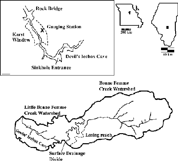
The field study was conducted in the Karst Window reach of the Devils Icebox Karst System (DIB) in central Missouri (Fig.1). The Karst Window is located in the downstream portion of the DIB system and is interpreted as a collapsed cave passage. Water flows from Connor’s Cave through the window and then under a rock bridge. Upon emergence from the rock bridge, the stream flows into non-karst areas.

Fig. 1. Location of Karst Window Study Locality in Rock Bridge Memorial State Park, Boone County, Missouri. The inset shows the location of the Karst Window relative to the downstream end of the Devil’s Icebox Cave System (Modified from Deike et al. 1960; St. Ivany 1988; Wicks and Engeln 1997).
Hydrologic insight is provided by previous studies of this system (Halihan et al., 1998; Wicks, 1997; Wicks and Engeln, 1997) and 2.25 years of discharge records (5 minute sampling interval) provided by Robert Lerch of the USDA-Agricultural Research Station at the University of Missouri. Discharge data were collected at a gaging station in the Karst Window (Fig. 2B) using a data logging pressure transducer placed in a stilling well at the edge of the stream channel to measure stage height (Lerch et al., 2001). The gage record provides timing and relative magnitude of baseflow and storm-induced discharges.
DIB is formed in the Mississippian Burlington Limestone and has surface and subterranean drainage components. Recharge for DIB is allogenically derived from sinking streams and sinkhole drainage. Surface water is diverted mainly from a losing reach of Bonne Femme Creek and pirated by the cave system west into the adjacent Little Bonne Femme watershed. The drainage basin for Devils Icebox is 31.6 km2, as defined by surface-water drainage patterns, dye tracing, and topography (St. Ivany, 1988).
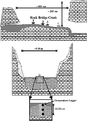
Fig. 2. Schematic Diagram of the Karst Window Study Locality, Rock Bridge State Park, Boone County, Missouri. Data logging stations are labeled numerically in the longitudinal cross section (top). The vertical placement of data loggers is depicted in the lower diagram that is oriented perpendicular to flow.
2.2 Climatic setting
Central Missouri has a humid middle-latitude temperate climate. Based on the Köppen classification system (see Lutgens and Tarbuck, 1995) Missouri is categorized as Cfa, indicating mild winters and warm summers (Fig. 3). The mean annual temperature is 12.5ºC. In an average year, 48 days have a high temperature greater than 32ºC and there are 113 days with lows of 0ºC or less. Precipitation is relatively evenly distributed throughout the year, with minimum precipitation in January and February and maximum in May and June (Fig. 3). On average, measurable precipitation occurs every 3.2 days and a 24-hour, 12.7 mm (0.5 inch) rain event occurs every 13.9 days.
Climatic Data were based on 1970-2000 daily summary observations at Columbia Regional Airport Weather Station and 1961-1990 (with extremes from 1890-2000) summary climate data from the Jefferson City Water Plant weather station (U.S. Cooperative Network Station 234271). All data are available from the Midwest Regional Climate Center.
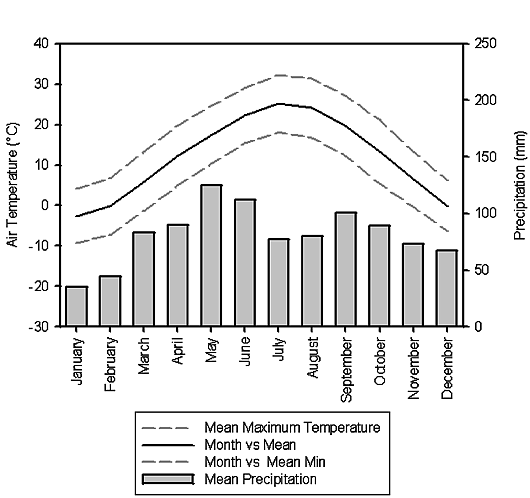
Fig. 3. Summary of mean annual temperature and precipitation for central Missouri.
2.3 Data collection
The longitudinal (upstream and downstream) and vertical thermal variations in the Karst Window substrate were measured using Onset Tidbit® temperature dataloggers with an accuracy of 0.2°C and a resolution of 0.16°C. Four stations were established in May 2000 with three temperature data loggers each (Fig. 2). At each station, dataloggers were emplaced at the base of the armor layer (coarse upper layer of sediment) 1-3 cm deep, at 7-10 cm deep, and at a 15-20 cm deep in the substrate. After installation of the data loggers, each station was back-filled with the sediment removed from the hole. During pilot studies conducted prior to this investigation, we qualitatively observed that fine sediment (sand and silt) disturbed or lost during excavation were naturally replaced on the timescale of days. Indeed, the sorting, size range, and compaction of the sediments seemed identical during excavation and re-excavation. In addition to substrate water temperatures, surface water temperature and stream stage were measured using a data logger and pressure transducer, respectively. All data were collected at a 15 minute interval during summer and fall 2000 and winter and spring 2001 (Table). Hourly meteorological data (including, temperature, incoming solar radiation, precipitation, and humidity) were obtained at a nearby (~9 km north) automated weather station (Sanborn Field) maintained by the University of Missouri Agricultural Experiment Station.
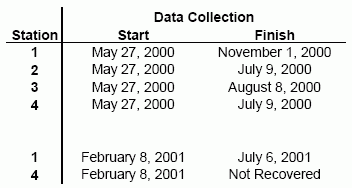
Table Data collection periods at the temperature data logging stations in the Karst Window. Note that complete substrate water temperatures are only available at station 1 for all periods.
Meteorological conditions likely vary to some degree between Sanborn Field and the Karst Window because of the intervening distance. However, general trends in the data collected at Sanborn Field are in good agreement with trends observed in the data collected at the Karst Window. For example, the timing and magnitude of precipitation at Sanborn field matches related characteristics of discharge events at the Karst Window. Solar radiation will be especially influenced by factors such as vegetative shading. However, as discussed later, the overall pattern and magnitude of solar radiation measured at Sanborn Field can be recognized in the thermal signature of the stream and substrate water at the Karst Window.
3. Results and Analysis
Fig. 4 provides an overview of the relation between air temperature, precipitation, and substrate water temperatures. The duration of data collection and sampling interval yielded a large number of observations. To facilitate the discussion, selected periods of data (10-15 day intervals) from Fig. 4 have been plotted individually in order to highlight the details of the thermal processes and variation. The periods selected for presentation are representative of conditions over the duration of the investigation. Furthermore, for periods with data from multiple stations, only data from stations 1 and 4 will normally be presented because observations at stations 2 and 3 represent a continuum of conditions intermediate between those at stations 1 and 4 (Fig. 5).
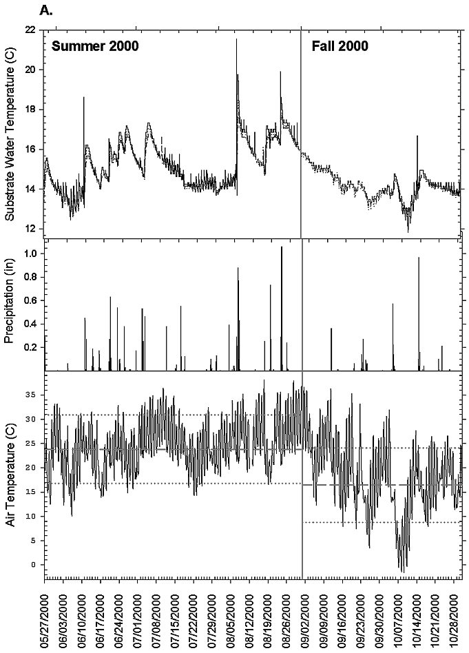
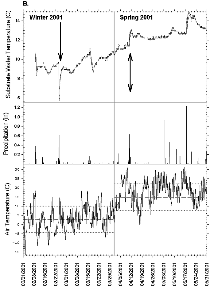
Fig. 4. Air temperature, precipitation, and substrate water temperature during the two data collection periods, (A) summer and fall 2000 and (B) winter and spring 2001. Mean, mean maximum, and mean minimum air temperatures for each season are indicated by the dotted and dashed lines. Substrate water temperatures are plotted for the data loggers at station 1. The arrow in (B) refers to the period examined in detail in Fig. 10.
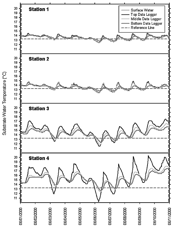
Fig. 5. Variations in substrate water temperature at each of the stations in the Karst Window during baseflow conditions for the period June 1-10, 2000. A reference line at 13.5ºC is shown on each plot as a point of comparison for the downstream increase in substrate water temperature.
3.1 Warm-weather conditions — late Spring, Summer, early Autumn
3.1.a. Baseflow conditions
During baseflow conditions, diurnal temperature variation dominates. There is a correlation between air temperature, substrate water temperature, and amount of incoming solar radiation (Fig. 6). On cloudy days (e.g., June 5 and 10) the daily air temperature range is reduced, as is the substrate water temperature range. Typically the peak diurnal temperature occurs at 14:00, which is one hour past the maximum sun angle, or true noon (because of daylight savings time). The one hour lag is likely caused by thermal inertia and the geometry of the Karst Window. The depression which contains the Karst Window is oriented north-south with steep east-west facing valley faces. The steepness and orientation of the Karst Window in combination with the tall tree canopy on either side of the channel, partially blocks the sun except during early to mid-afternoon. Obviously, intermittent cloud cover on an otherwise sunny day (e.g., cumulus clouds), or other atmospheric conditions, also regulate the timing of peak diurnal temperature in the stream.
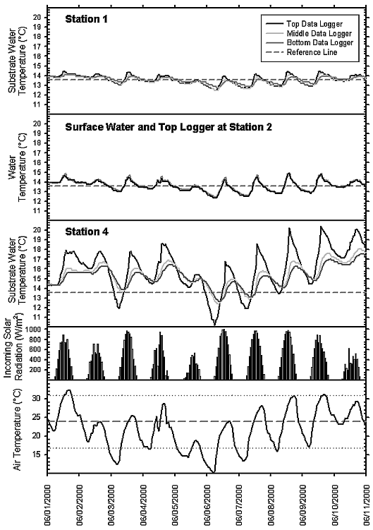
Fig. 6. Baseflow conditions from June 1-10, 2000, in the Karst Window. The dotted lines in the air temperature plot are mean high and low summer temperatures and the dashed line is mean summer temperature.
During baseflow conditions, temperatures in the substrate vary both longitudinally (parallel to flow) and vertically. Station 1, located near (~10 m) the cave spring (Fig. 6), shows a mean daily range of 1.1ºC beneath the armor layer (top data logger) and 0.5ºC deeper in the substrate (bottom data logger). The temperatures of the upper substrate water (black line) and surface water (dark gray line) at station 2 are very similar. Over the ten day baseflow period, the temperature range at station 1 is 1.4ºC (bottom logger) to 2.0ºC (top logger) and temperatures in the upper substrate display greater variation than temperatures in the lower substrate.
Station 4, located approximately 60 m from the cave spring, shows considerably more variation than station 1 (Fig. 6). In the vertical dimension, the mean daily temperature range below the armor layer (top data logger) at station 4 is 4.8ºC with a total range for the period of 10.2ºC. The loggers in the lower part of the shallow hyporheic zone show daily variations of 2.2-3.0ºC and a total range for the period of 4.9-5.7ºC. Thus, at both stations 1 and 4, daily and longer-term temperature fluctuations are reduced by approximately half with depth in the hyporheic zone. If this trend extrapolates linearly into the shallow hyporheic zone, then no variation in substrate water temperature should occur beginning at depths between 30-40 cm. The mean temperature in the lower substrate over this baseflow period at station 4 was 15.5ºC indicating that the water warmed by an average of ~2ºC over the 40 m interval between the stations.
3.1.b Storm-induced conditions
Storm-induced discharge events are triggered by frontal passages and convective storms. The magnitude and intensity of precipitation required to affect discharge in the DIB system is dependent upon antecedent conditions including precipitation, soil moisture, and evapotranspiration. During summer conditions, storms with a minimum intensity of 10 mm/hr and a total rainfall of 10 mm or greater generally result in increased discharge at the Karst Window. Such events occur approximately 2-3 times per month on average in central Missouri. During increased discharge, flow characteristics and water quality parameters are affected, including water temperature.
Changes occur in the longitudinal and vertical temperature regime in the Karst Window at the onset of storm-induced discharge conditions. At the beginning of a storm pulse (Fig. 7) there is a short-lived (in situ by extended exposure to solar radiation.
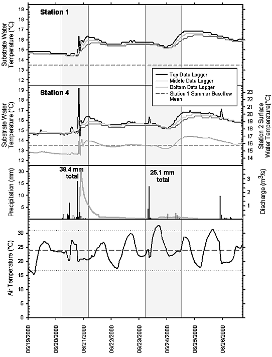
Fig. 7. Storm-induced flow conditions from June 19-27, 2000. Surface water temperatures at station 2 are plotted along with substrate temperatures at stations 4 and are purposefully offset (downward) by 3ºC because they are identical to the temperatures in the upper substrate at station 4.
After the spike, temperatures rapidly equalize vertically and longitudinally downstream and steadily rise during the ascending limb of the hydrograph. Peak discharge is lagged 2-4 hours behind the precipitation event because of transit times through the system (Halihan et al., 1998). Subsequently, substrate temperatures steadily decrease (~0.25°C/day) over a period of several days until baseflow conditions reestablish and the diurnal fluctuations begin to dominate.
3.2 Cool-weather conditions — late Autumn, Winter, early Spring
3.2.a Baseflow conditions
During cooler weather, the relation between substrate water temperature variations and discharge conditions is similar to that observed during warm-weather periods; however, the thermal gradient in the substrate may be inverted. When air temperatures are near or below the mean annual temperature (12.5ºC), temperatures usually increase with depth in the substrate. From February 14-18, 2001, (Fig. 8) and October 4-20, 2000, (Fig. 9) air temperatures remained below mean annual temperature, resulting in a thermal inversion in the stream substrate.
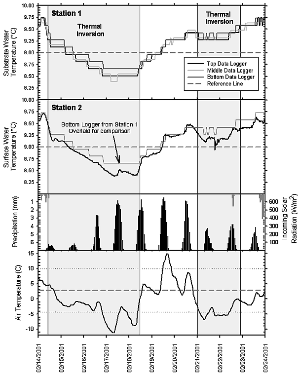
Fig. 8. Baseflow conditions from February 14-24, 2001. Shaded areas indicate periods of thermal inversion in the hyporheic zone.
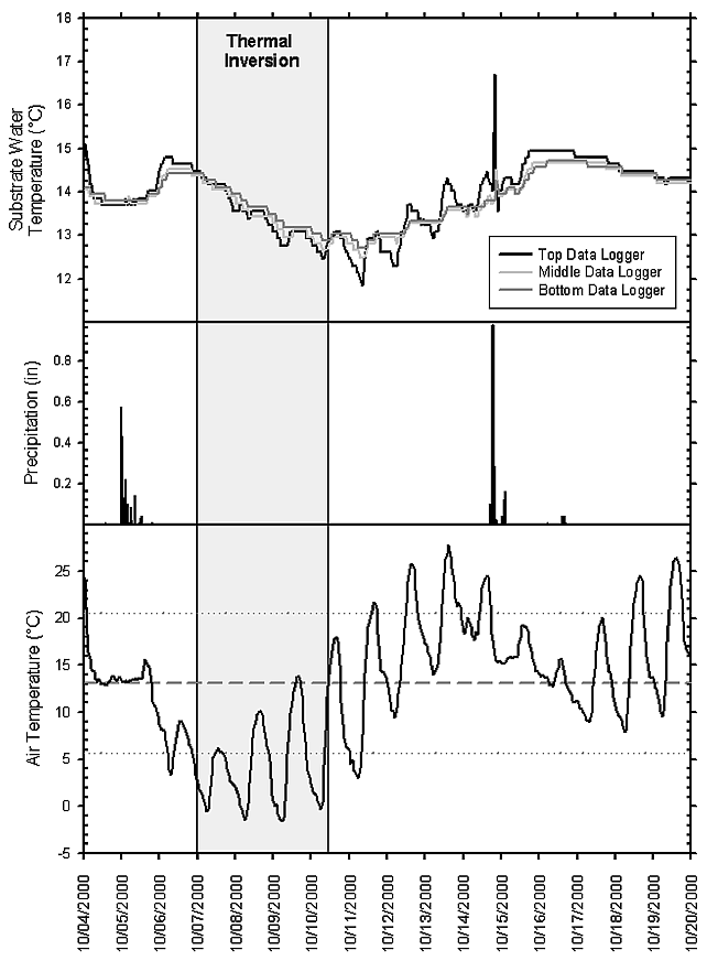
Fig. 9. Baseflow and storm-induced conditions from October 4-20, 2000. Shaded areas indicate periods of thermal inversion in the hyporheic zone.
Additionally, air and water temperatures are not synchronized with incoming solar radiation (Figure 8). For the period of February 14-24, 2001, air and surface water temperatures appear to be unrelated. During cold weather, for example, when Arctic and polar air masses associated with high pressure ridges have invaded the region, several consecutive sunny days are required before warming is initiated in the stream substrate and surface water. In February 2001, five consecutive sunny days (February 16-20) were required to warm the substrate water 0.75ºC and there was a two day lag before warming initiated (Fig. 8). During this period, substrate (upper and lower) and surface water temperatures are well correlated.
3.2.b. Storm-induced conditions
Substrate temperature trends during storm-induced discharge are dependent upon the temperature of the precipitation. The passage of a warm front through mid-Missouri on February 23-24, 2001 resulted in a dramatic drop in substrate temperatures (Fig. 10). The warm front approached the area at a time when there was ~30 mm of snow on the ground and air temperature had remained below freezing for 63 hours. The initial rainfall (~37 mm) preceding the front fell during a period of gradual warming to a mean temperature of 2.5ºC. Thus, the hydrologic system experienced a rapid influx of a large volume of very cold water (shaded box in Fig. 10). The temperature in the lower substrate did not decrease as much as in the upper substrate: the bottom data logger recorded minimum temperatures 1.25ºC warmer than the upper and middle data loggers (versus about 0.5ºC range during warm-weather conditions, see Fig. 7). Around 06:00 on the February 24, the front moved into the region and temperatures rose quickly to 14ºC, yielding warmer precipitation, which quickly reversed the temperature drop.
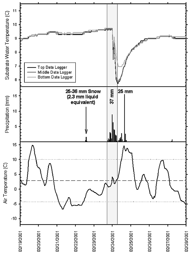
Fig. 10. Storm-induced flow conditions from February 19-28, 2001. The shaded box indicates a period of rapid influx of a large volume of very cold water into the stream system following passage of a warm front.
4. Discussion
Direct measurements of surface water temperature are only available from the stream gauging station near station 2. Nonetheless, surface water and upper substrate (top data logger) temperatures closely resemble one another (Figures 6 and 7). This indicates that regardless of the discharge conditions, the temperature of the upper substrate is similar to the surface water temperatures. Thus, temperatures in the upper hyporheic zone are largely a function of air temperature. Over the complete period of observation (Table) the temperature range of the upper substrate, and presumably the surface water (only have data for station 2), was 15.8ºC, whereas the lower substrate temperatures varied by 10.9ºC. General trends in the substrate temperature correspond with trends in the air temperature, although the absolute range of air temperatures is much larger (Fig. 4; mean annual temperature range is ~33ºC). Thus, the temperature range in the substrate are muted relative to the air temperature range.
During summer baseflow conditions, thermal gradients in the substrate tend to be steeper than for analogous cool-weather events. This is likely due to the greater effectiveness of solar radiation at heating the stream during the summer months. Solar radiation is not as effective during the winter months because of lower sun angles and shorter daylight intervals. Winter baseflow conditions tend to develop an inverted substrate temperature gradient when ambient air temperatures are below 12-13ºC. As air temperatures approach (cooling or warming) mean annual temperature—12.5ºC—vertical homogenization of substrate temperatures occurs because water exiting the cave is in equilibrium with mean annual temperature (e.g., see Figure 8 between the thermal inversions). Therefore, the relation between upper and lower substrate temperatures is dependent upon differences in discharge, meteorological conditions, and seasonal variations.
The greatest downstream temperature variation occurs in the upper substrate (Fig. 5), and may equate to several Celsius degrees over a 60 meter interval. Unfortunately, longitudinal variation during winter baseflow events could not be fully assessed because of the loss of station 4 (Table). A large degree of warming occurs between stations 2 and 3 during warm weather conditions (Fig. 5), so it is possible that a similar, but opposite, trend would occur between the stations in cold-weather conditions due to heat loss at the air-water interface. Thus, longitudinal thermal variations during summer baseflow conditions occur quite rapidly and are attributable to the input of solar radiation.
Storm-induced discharge conditions are characterized by a near vertical and longitudinal homogenization of temperature in substrate and surface water. This decrease in thermal variation is likely a result of the volume of discharged water overcoming the equilibration capabilities of the system. In most cases, precipitation inputs cause a warm pulse to move through the system. However, winter events, particularly those associated with snow melt and near-freezing precipitation, can cause cool pulses with steep thermal gradients (Fig. 10). Thus, seasonality plays a role in the predominant direction (warming or cooling) of thermal variation. The largest short-term variations experienced regularly by the system are the temperature spikes related to subsurface throughflow from the adjacent valley slopes. These spikes are very short duration (
In late spring and early fall, precipitation tends to be derived more commonly from moist sub-tropical air masses moving north to interact with cooler air masses resulting in warm thermal pulses in the substrate, even if air temperatures are low or decreasing (Fig. 9). As one would expect, spring and autumn appear to be transitional periods when ambient air and precipitation temperatures tend to be closer to the mean annual temperature. Thus, there is less contrast with thermally equilibrated water discharging from the cave system, resulting in smaller thermal gradients.
The ability of the hyporheic zone to moderate temperature change appears to be proportional to the intensity of the thermal event. Exploring this relation is worthy of future research. One possible hypothesis is that the hydraulic conductivity of the sediments may determine the thermal buffering capability of a substrate. Higher hydraulic conductivities should allow more rapid interchange between surface and substrate waters, thereby decreasing the ability to dampen thermal fluxes. Conversely, low hydraulic conductivities would effectively moderate thermal variation.
5. Final considerations
5.1 What is the relation between stream water and substrate water temperature?
Temperatures in the upper portion of the hyporheic zone are strongly linked to air temperatures via the surface water. Temperatures in the lower substrate show considerably less variation as depth increases (Figure 5 and 9). Accordingly, the annual temperature range in the lower portion of the shallow hyporheic zone is reduced by one-third, relative to the variation observed in the surface water and upper substrate. Thus, the upper substrate water (0-5 cm) and the surface water closely mimic one another in temperature range and variation.
5.2 How do substrate temperatures vary vertically and longitudinally downstream?
The relation between upper and lower substrate temperatures is dependent upon differences in discharge, meteorological conditions, and seasonal variation. The upper portion (0-5 cm) of the shallow hyporheic zone is subject to a thermal regime very similar to surface stream water. However, below these depths the sharpest temperature fluctuations are effectively muted within the stream substrate. For example, rapid cool pulses and warm spikes diminish quickly with depth in the substrate (Figures 7 and 10). More frequent diurnal variations, particularly those associated with baseflow conditions (Fig. 5), are also dampened within the substrate. Temperature fluctuations are also reduced longitudinally in the lower substrate with respect to simultaneous changes in the surface and upper substrate waters.
5.3 What are the roles of annual, seasonal, and diurnal temperature variation in regulating stream and substrate water temperature?
Stream and substrate temperatures correlate well with annual scale variations in air temperature (Fig. 4). Ultimately, air temperature, which explains much of the variation in stream and substrate temperatures, is regulated by the complex interactions of short- and long-term meteorological conditions and seasonal characteristics. Annual temperature trends are a function of meteorological parameters such as solar radiation, sun angle, day length, humidity, evapotranspiration, and dominant air masses, all of which vary regularly with the seasons. For example, during the summer months, solar radiation is more effective at heating the air and stream water. These effects combine with warmer seasonal temperatures to increase water temperature and diurnal range, particularly during baseflow conditions.
5.4 How does variation in discharge related to storm-induced flood events affect stream water and substrate water temperature?
Storm-induced discharges typically inundate the hydrologic system with a large volume of thermally-unequilibrated water. This overcomes the thermal buffering capacity of the stream substrates and leads to increased homogenization of temperatures vertically and longitudinally in the stream and sediment. Thus, storm-induced thermal pulses are not significantly reduced within the substrate, but the rate of temperature change is relatively gradual (0.25-0.5ºC/day) and the variation is spread out over several days.
Acknowledgements
Funding for this work was provided by the National Science Foundation (A POWRE award to CMW), Sigma Xi (TJD), and the Cave Research Foundation (TJD). The authors would like to thank Robert Lerch of the USDA Agricultural Experiment Station for stage data from the Karst Window.
References
- Deike, G., Hopson, H., Sturmfels, G., Deike, R., Barnholtz, S., and Lang, K. 1960. Devils Icebox, Boone County, Missouri, Chouteau Grotto of the Nat. Speleo. Soc., Columbia, MO, 1960.
- Halihan, T., Wicks, C.M., and Engeln, J.F. 1998. Physical response of a karst drainage basin to flood pulses; example of the Devil's Icebox cave system (Missouri, USA), J. Hydrol., 204 (1-4), 24-36.
- Lerch, R.N., Erickson, J.M., and Wicks, C.M., 2001. Intensive water quality monitoring in two karst watersheds of Boone County, Missouri, in Proceedings of the 15th National Cave and Karst Management Symposium (October 16-19, 2001), edited by T. Strong, National Cave and Karst Management Symposium Steering Committee, Tuscon, AZ.
- Lutgens, F.K., and Tarbuck, E.J. 1995. The Atmosphere: An Introduction to Meteorology, Prentice-Hall, Inc., Englewood Cliffs, NJ.
- St. Ivany, G. 1988. Geologic and hydrologic characteristics of the Gans, Bonne Femme, and Clear Creek watersheds and the Pierpont Karst Plain near Rock Bridge Memorial State Park, Boone County, Missouri, Missouri Department of Natural Resources, Division of Geology and Land Survey, Jefferson City, MO.
- Wicks, C.M., 1997. Origins of groundwater in a fluviokarst basin; Bonne Femme Basin in central Missouri, USA, Hydrogeol. J., 5 (3), 89-96.
- Wicks, C.M., and Engeln, J.F. 1997. Geochemical evolution of a karst stream in Devils Icebox Cave, Missouri, USA, J. Hydrol., 198 (1-4), 30-41.