D. Taboroši (1), J. W. Jenson (2) and J. E. Mylroie (3)
(1) Water & Environmental Research Institute of the Western Pacific,
University of Guam, Mangilao, GU 96923, USA
(2) Water & Environmental Research Institute of the Western Pacific,
University of Guam, Mangilao, GU 96923, USA
(3) Department of Geoscie nces, Mississippi State University ,
Mississippi State, MS 39762, USA
Abstract
In contrast to Paleozoic limestones where drainage is based on classical cave systems (secondary porosity), young limestones of uplifted carbonate islands retain substantial distributed primary porosity. Consequently, speleogenesis on such islands is restricted to environments where dissolution is sufficiently focused to produce caves. Thus, on Guam and similar islands, solution voids large enough for human traverse occur only in settings where dissolution has been focused by hydrologic or geologic boundaries. In the vadose zone, these boundaries are lithologic contacts or structural discontinuities that channel the flow of aggressive water. In the phreatic zone, the boundaries are hydrologic contacts, where aggressive water is produced through the mixing of saturated waters. These geologic and hydrologic settings are sites of significant speleogenesis, each characterized by morphologically and hydrologically distinct types of caves.
Keywords: speleogenesis, secondary porosity, groundwater, freshwater lens, Northern Guam Lens Aquifer
Introduction
In the young limestones of uplifted carbonate islands, the flow of groundwater rearranges the porosity of the original high-porosity matrix so that flow is increasingly directed through a complex of relatively small but numerous, widely distributed, and interconnected secondary pathways that form along the hydraulic gradient (Vacher and Mylroie, 2002). This is in contrast to the classical karst cave systems in diagenetically mature limestones, in which flow concentrates along intersecting structural discontinuities in an otherwise low-permeability rock matrix to eventually form a small number of long, large-radius conduits that control nearly all of the groundwater transport in the aquifer (Ford and Williams, 1989). In the more diffuse flow environment of young limestones, the development of caves is much more subdued and restricted. Significant preferential flowpaths do form in the limestones of many carbonate islands, but their contribution to the overall transport of water is insufficiently known, and their formation is limited to highly specific geologic and hydrologic settings.
With carbonate islands worldwide experiencing increasing demands on their limited water resources as populations and demand for utilities and water-based services grow (UNU, 1995), improved understanding of their aquifers is needed to support sustainable development. On Guam, Mariana Islands, 80% of the water consumed by its 150,000 permanent residents and more than 1,000,000 tourists per year is drawn from the Northern Guam Lens Aquifer (NGLA), a karst aquifer in the limestone plateau that occupies the northern half of the island. The island presently extracts over 150,000 m 3 /day of the aquifer's current estimated sustainable yield of 220,000 m 3 /day. The NGLA is vulnerable to overuse and contamination, in particular to seawater intrusion from overpumping and to sewage and other contaminants, which, once released at the surface can descend rapidly to the water table through porous limestone. Therefore, an accurate understanding of the aquifer's hydrologic properties is critical to its successful utilization and protection. While previous studies of the NGLA have been oriented toward determining engineering parameters to support water production ( Mink, 1976; CDM, 1982; Contractor, 1983; Ayers and Clayshulte, 1984), recent research (Mylroie et al., 1999; 2001; Taboro š i, 1999; 2000) has focused on gaining a more fundamental understanding of the aquifer's karst geology in order to develop a more accurate aquifer conceptual model.
Mylroie et al. (2001) described the karst features of Guam in terms of a general model of carbonate island karst (Mylroie and Vacher, 1999; Mylroie and Jenson, 2000). This paper focuses on the caves of the NGLA and the geologic and hydrologic settings in which they form. Since caves on Guam and similar islands likely exert important influence on the occurrence and quality of water in the aquifers, u nderstanding their origin, morphology, and hydrologic properties is prerequisite to the successful management of the islands' freshwater resources.
Study area
Located at 13 o 28'N, 144 o 45'E, Guam is the largest island (549 km 2 ) in Micronesia (Fig. 1). Elongate and generally rectangular in shape, it is 48 km long and 6-19 km wide, and is divided into two separate geologic provinces by the Pago-Adelup Fault: s outhern Guam, a rugged volcanic highland with several limestone outliers; and northern Guam, an undulating limestone plateau that is the subject of this study. The northern plateau is tilted from 60 m elevation at the south end to 150-180 m elevation at the north end. The source of fresh water in the aquifer is the freshwater lens that underlies that plateau, floating on and remaining distinct from the saline water that permeates the rock below it (Fig. 2a) (Vacher, 1988). At the southern end, the northern Guam plateau is bounded by a major fault beyond which lie rugged uplifted volcanic highlands. Elsewhere, the plateau is fringed by cliffs that rise precipitously over the sea, except were fronted by a narrow coastal terrace. The principal geologic reference for Guam is still the USGS report by Tracey et al. (1964), which includes a 1:50,000 scale geologic map (simplified in Fig. 1).
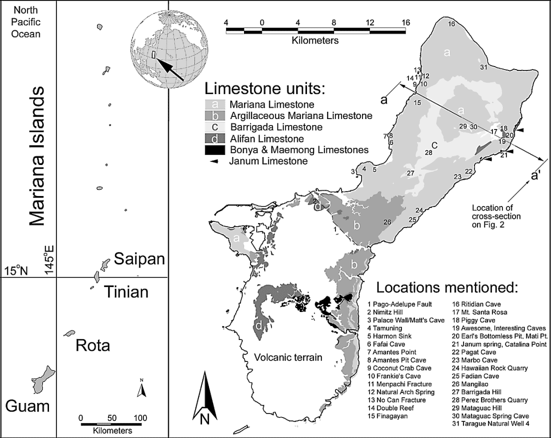
Fig. 1. Location of Guam, with
a simplified geologic map of the island, showing locations of features mentioned in text.
The oldest rocks on the island are volcanic units of Middle Eocene to Miocene age (Reagan and Meijer, 1984). They dominate southern Guam and form the basement beneath the northern Guam limestone plateau. In southern Guam, these units are locally overlain by the Miocene Bonya and Alifan Limestone formations, which occupy the high points of volcanic terrain. In northern Guam, the lowermost limestone unit is the detrital Mio-Pliocene Barrigada Limestone, a well lithified to friable white detrital limestone, deposited in a bank water environment. It comprises most of the bedrock and is the principal aquifer unit. The Barrigada Limestone extends to the plateau surface only in the interior of northern Guam. Elsewhere it grades laterally and upward into the Plio-Pleistocene Mariana Limestone, a complex of reef and lagoonal limestones that form 75% of the island's exposed limestone surface. At the southern end of the plateau, the surface is composed mostly of a buff-colored limestone unit, which Tracey et al. (1964) mapped as the Argillaceous Member of the Mariana Limestone. Minor outcrops of Miocene argillaceous Janum Limestone, and Holocene reef Merizo Limestone are exposed in several coastal areas. The generally flat surface of the northern plateau is interrupted by a limestone horst, Barrigada Hill (203 m), and two volcanic outcrops, Mt. Santa Rosa (262 m) and Mataguac Hill (192 m).
Guam 's climate is tropical wet and dry, with an equable mean annual temperature of 27 o C. January through May is the dry season, broken by occasional showers. The wet season lasts from July to November, during which heavy rains and tropical storms are common. The mean annual precipitation ranges from 216 cm/yr on the west coast, near Apra Harbor, to 292 cm/yr on the limestone peaks of southern Guam, with the northern plateau receiving an average of 215-250 cm/yr (Lander, 1994). Northern Guam has no perennial streams, except a few small rivers on the argillaceous limestone at its southern end. Its vegetation is dominated by thick shrub jungle in the undeveloped portions of the plateau, and limestone forests on the coastal terraces.
Methods and database
The karst of northern Guam was systematically investigated during a two-year field study ( Taboro š i, 1999; 2000). The central objective of the study was to inventory karst features of the Northern Guam Lens Aquifer. This project was conducted through the systematic collection of unpublished data, interviews with local residents, aerial surveys and analyses of aerial photographs, and hundreds of hours of fieldwork in search of caves and related features, along with boat and SCUBA surveys of the coastal areas. As fieldwork progressed and an understanding of the types of karst features found on the island began to emerge, features were classified according to their morphology and inferred origin. Standard National Speleological Society techniques (Dasher, 1994) were applied, using a compass, clinometer, and measuring tape. Submerged features were explored using SCUBA, and were sketched rather than surveyed.
A comprehensive database was compiled, containing information on thousands of karst landforms on the island, including 139 caves in the NGLA ( Taboro š i, 2000). The database includes GIS (Geographic Information System) coverages, which detail the distribution of karst features on the island. These are deposited at the Water and Environmental Research Institute of the Western Pacific (WERI), University of Guam.
Speleogenesis in the Northern Guam Lens Aquifer
Because the dissolutional attack on carbonate islands is typically diffuse, there is little or no focusing of aggressive water to produce caves, as in classical karst terrain. Consequently, speleogenesis on such islands is focused along hydrologic or geologic boundaries (Mylroie et al., 1999; Vacher and Mylroie, 2002). In the vadose zone, these boundaries are geologic contacts or structures that focus the flow of aggressive water. In the phreatic zone, the boundaries are hydrologic contacts that produce aggressive water through the mixing of saturated waters (Bögli, 1964).
The zones of significant speleogenesis in northern Guam are: 1) the karst surface in immediate contact with aggressive meteoric water; 2) joints, fractures, and faults, whose planar surfaces can capture preferential flow; 3) the contact between limestone and non-carbonate basement units in the vadose zone, where groundwater flow is controlled by basement topography; 4) the top of the freshwater lens (epiphreatic zone), where incoming vadose and resident phreatic fresh waters mix; 5) the base of the freshwater lens (halocline), where fresh and saline phreatic waters mix; 6) the distal margin of the lens, along the island's perimeter, where epiphreatic zone and the halocline converge and water discharges from the lens; and 7) the inner margin of the lens, where the top of the lens is in contact with basement non-carbonate units, and incoming vadose water, descending along the flank of the basement rock that stands above sea level, mixes with the phreatic freshwater (Fig. 2b). Cave development within these zones is predicted by the Carbonate Island Karst Model (Mylroie and Jenson, 2000). It must be noted that the first two zones are determined solely by lithologic and structural boundaries and can be considered static. The remaining zones are defined by hydrologic boundaries and as such, their positions vary with relative sea level changes. As the relative sea level changes, the island's freshwater lens, which floats on seawater, also changes its elevation. Thus, the hydrologic boundaries and associated zones of enhanced dissolution migrate through the rock body, leaving behind inactivated karst features indicative of their previous positions. For example, vadose caves are not uncommon below the ocean surface along Guam 's coast, due to the fact that Quaternary sea level fluctuations caused up to 120 m of what is currently in the phreatic zone to spend time under vadose conditions in the past.
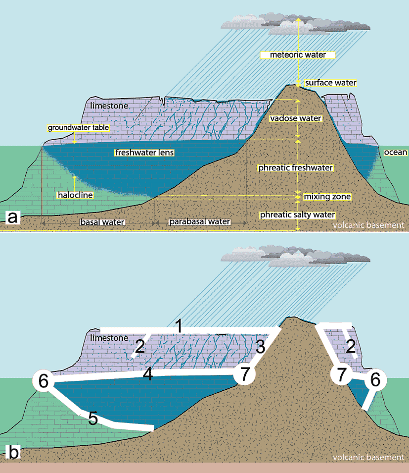
Fig. 2. Cross-section through northern Guam, illustrating the following: a) The Ghyben-Herzberg Model of freshwater lens and the cross-section of the Northern Guam Lens Aquifer; b) Z ones of speleogenesis in northern Guam: 1) the karst surface (epikarst); 2) joints, fractures, and faults; 3) the vadose contact between limestone and basement non-carbonate units; 4) the top of the freshwater lens; 5) the base of the freshwater lens; 6) the lens distal margin; and 7) the lens inner margin.
Karst surface
On Guam and other carbonate islands, most meteoric precipitation captured by the carbonate terrain percolates through the vadose zone to eventually recharge the lens (Jocson et al, 2002; Contactor and Jenson, 2000). This type of water input is known as autogenic recharge (Mylroie, 1984). Because it is slightly acidic from the incorporation of atmospheric CO 2, meteoric water is normally capable of dissolving limestone on contact. The dissolution is typically unfocused, and results in the formation of epikarst – a heavily weathered layer of rocks at and immediately below the surface (Fig. 2).
On Guam, most dissolutional voids in this zone are not large enough to be entered by people and are, therefore, not considered to be caves according to conventional definitions (Jennings, 1985). They include soil pipes, pits and channels – some of which are dissolutional enlargements of primary voids in reef rock. Their diameter and frequency diminishes with increased depth, because the percolating water rapidly loses dissolution potential as it moves downward. The contrast between the epikarst and the rest of the vadose zone below can be striking in limestone quarries and road cuts, where exposed soil pipes are densely spaced at the surface but nearly absent at depths greater than 4 meters.
Although most meteoric water percolation into the epikarst is diffuse, there are small-scale variations in vadose input, which can locally result in discrete input points. It is thought that this process produces vadose shafts, also known as pit caves (Mylroie and Carew, 1995a). These features are vertical, cylindrical shafts with width to depth ratios less than one (Mylroie and Carew, 1995b) and are formed through dissolution by descending meteoric water. In northern Guam, they exist across a broad range of sizes, from several meters deep and less than a meter wide shafts that barely penetrate the epikarst (Fig. 3a), to large caves that are several meters in diameter and tens of meters deep (Fig. 3b). They are typically open to the surface, but small shafts closed by soil plugs and pit caves roofed by limestone bedrock have also been documented, indicating that such voids occur with greater frequency than observed. Hydrologically, the shafts act as vadose bypasses by allowing the rapid downward flow of meteoric water, instead of slow percolation through the epikarst. None of the features documented on Guam deliver water directly to the lens, because their depth is greatly exceeded by the 60 to 180 m thick section of limestone in the vadose zone. Vadose shafts occur as isolated examples, such as the 45 m deep Amantes Pit Cave (Fig. 3b), or in occasional complexes, such as one along the cliff line overlooking Catalina Point, where the landscape is studded with hundreds of pits. These complexes, however, do not reach extreme densities reported from other islands, such as the Bahamas, where pit caves can number more than a 1000/km 2 (Pace, 1992).
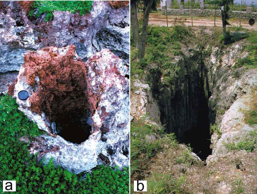
Fig. 3. Vadose shafts: a) A small, 1-m deep pit containing paleosol; b) Amantes Pit Cave, a large, 45-m deep, 6-m wide shaft.
Joints, fractures, and faults
Vadose flow from the surface or the epikarst can be concentrated by joints and fractures, resulting in their dissolutional enlargement and, sometimes, the creation of cave passages. Caves of this type are common in areas of extensive tectonic deformation, such as near Mt. Santa Rosa and Nimitz Hill. They are generally not complex and are rarely more than simple modifications of a mechanical discontinuity by vadose groundwater. Examples include Earl's Bottomless Pit on the east side of Mt. Santa Rosa, a fracture widened to about 60 cm, but which can be rappelled to a depth of 27 m; the numerous corridors and shelter caves on Nimitz Hill, which are dissolutionally enlarged joint sets and dip slip faults (Fig. 4a); and discharging fractures in the cliffs at Double Reef, where vertical fractures perpendicular to the coastline are up to several meters wide and traversable to over 30 m inland. These fractures discharge perennial streams of freshwater floating on seawater. On the more complex end of the spectrum are caves such as Admirable Cave, Birthday Cake Cave, and Japanese Caves (Fig. 4b) which are mostly subvertical fissures developed along fractures and tension gashes by vadose dissolution, but which also contain horizontal dissolutional passages, as well as rooms showing evidence of phreatic dissolution. Fracture caves were first reported from a carbonate island by Ollier (1975) who termed them Inakebu type, and are apparently extremely common on some islands. Recent work on Tinian, an island north of Guam, has revealed a large number of them, reaching up to 35 m in depth and over 300 m in length (Stafford et al., 2003a.). Caves that formed along faults have also been observed on Tinian, whereas on Guam, enhanced dissolution along faults has been seen to produce only land surface corridors, such as the Mati Point Fracture.
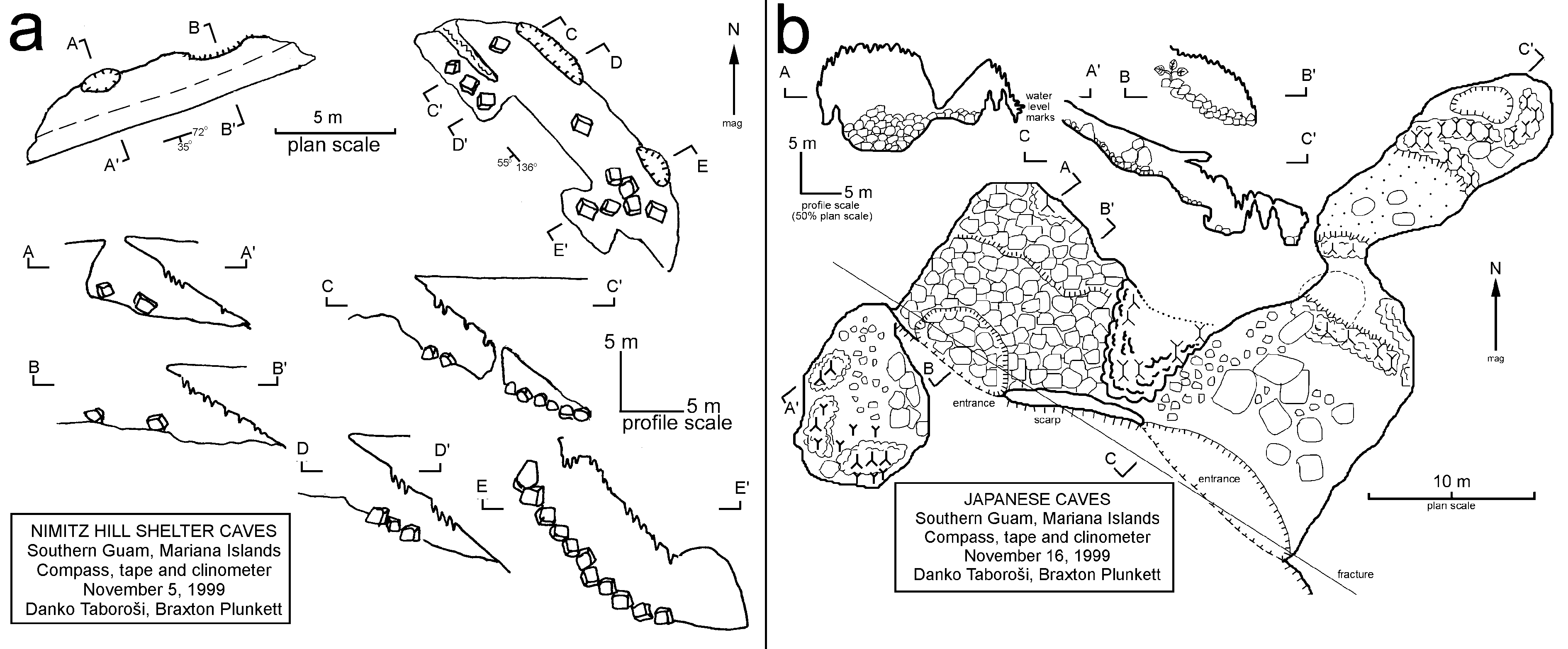
Fig. 4. Fracture caves on Nimitz Hill: a) Shelter caves formed by dissolutional widening of dip slip faults; b) Largely fracture-controlled Japanese Caves. Note the alignement of two collapse entrances and the extent of the cave (profile C-C') along a fracture.
Carbonate-basement contact in the vadose zone
On islands where non-carbonate basement units extend above the sea level ( composite islands of Vacher, 1997), they play an important role in the focusing of vadose flow (Fig. 2). Because these units are largely insoluble and impermeable, they allow the surface flow of captured meteoric water. Such allogenic water (Mylroie, 1984), is focused into ephemeral streams within surface topographic valleys, and flows down-gradient over the non-carbonate terrain. Upon reaching the limestone, the water sinks into the subsurface, where it continues to move via underground passages that form at the contact between the basement non-carbonate units and overlying limestone. These basement conduits are created and enlarged by the allogenic water they conduct. The water, having had little or no contact with carbonate rocks, tends to have low dissolved solid concentrations and remains dissolutionally aggressive.
Some of the longest caves in northern Guam, such as Piggy Cave, Awesome Cave, and Interesting Cave (Fig. 1), are formed in this way and are found on the flanks of Mt. Santa Rosa and Mataguac Hill—volcanic outcrops protruding through the limestone plateau (Fig. 2). Mt. Santa Rosa, with an area of only 1.31 km 2 (1% of the plateau surface) exhibits both first and second order streams, divided into 9 drainage basins. These feed into sinkholes located at the surface contact with the surrounding limestone. The sinkholes' swallow-holes (insurgences) represent entrances to basement conduits, some of which are traversable stream caves, while others are entirely filled by alluvium. The basement conduits are essentially roofed valleys, carrying ephemeral streams that are simply underground continuations of the surface streams. They closely follow the contact between limestone and basement units (Jenson et al., 1997) and range in size from short and simple ones, such as Mataguac Spring Cave (Fig. 5a) to more complex caves, such as Piggy Cave (Fig. 5b). Traversable for 120 m, Piggy Cave consists of a single passage, which is an actively down-cutting vadose canyon, and several large rooms. The active passage is incised into the volcanic bedrock up to several meters below the contact with overlying limestone, clearly visible in the passage walls (Fig. 6). Above it, there are several larger rooms, which have most likely formed by progradational collapse of the stream passage, breaching the land surface in several places and creating additional entrances and skylights.

Fig. 5. Basement conduit caves: a) Plan and passage cross-sections of Mataguac Spring Cave, a simple linear passage; b) Plan and profile of Piggy Cave, consisting of a vadose canyon and large rooms formed by its progradational collapse.
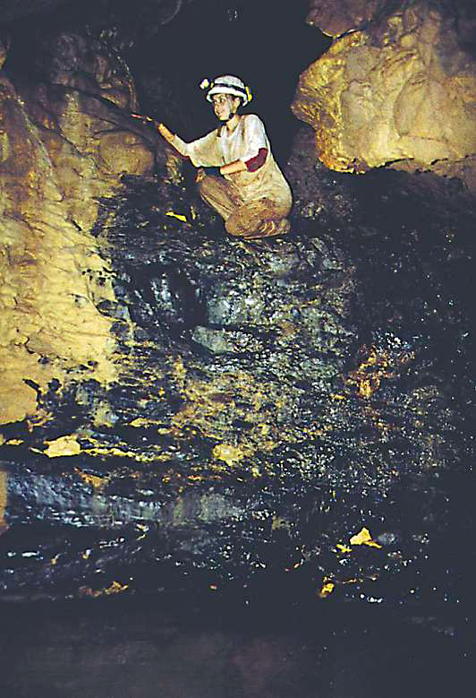
Fig. 6. Stream passage in Piggy Cave. Note the black volcanic units comprising the floor of the passage, and the contact with overlying limestone in the passage walls.
In northern Guam, caves of this type are traversable until closed by a collapse or a siphon, or until the passage becomes too narrow. No cave can be followed to its discharge end or the water table. Considering the topography of the basement volcanic units (Vann, in prep.), most basement conduits and caves deliver water to the freshwater lens. At least one cave, however, located on the south side of Mt. Santa Rosa where the basement volcanic units are located near the sea level, discharges water directly into the ocean. Known as Janum Spring after the local Chamoru word h å nom (water), this cave used to be traversable for approximately 20 m, prior to being closed by a collapse during the 8.2 magnitude earthquake that struck the island in August 1993. The spring,
thought to be the mouth of a basement conduit trunk, discharges water of excellent quality, and has been observed to discharge reddish sediment-laden plumes following heavy rainfalls.
Speleogenesis at the carbonate-basement contact has been hypothesized even on islands where basement units do not extend to the surface. In Bermuda, for example, extensive caves are thought to be associated with collapse of deep voids formed at the limestone-basement contact and progradation of the caves to the land surface (Mylroie et al. , 1995). A similar scenario cannot be excluded on Guam, where several caves and collapse sinkholes appear to heave formed by progradational collapse of deep voids. In Tarague Embayment, for example, there are eight deep vertical-walled cenotes largely filled by collapse boulders. Of these, we have explored four by SCUBA and found that the deepest one extends to at least 21 m below the modern sea level (Fig. 7a). The origin of the voids that triggered the collapse is still unknown. The limestone-basement contact underlying Tarague area is thought to be deep enough to have remained in the phreatic zone throughout the Quaternary sea level fluctuations (Vann, in prep.).
Top of the lens
Although both phreatic freshwater and downward percolating vadose freshwater are generally at or near equilibrium with respect to dissolved carbonates, their mixture can become undersaturated with respect to CaCO 3 through a chemical phenomenon known as mixing corrosion (Bögli, 1964). The dissolution potential may be further increased by the local increase in CO 2 partial pressure, due to the oxidation of organic material brought in by descending vadose water (Mylroie and Carew, 1997). This results in the formation of voids at the top of the lens (Harris et al., 1995) (Fig. 2). The voids are hypogenic (Palmer, 1991), produced without connections to the land surface. Where they occur near the surface, however, they may be breached by roof collapse.
This occurs in the Bahamas, where one of the past relative sea-level high stands placed the top of the freshwater lens near the modern day land surface. The voids formed at the top of the lens, but following a sea level drop and the loss of buoyant support, their roofs had collapsed, opening the voids to the land surface. The resultant morphology is partially or completely de-roofed lenticular depressions, up to 10 m across and up to 5 m deep, named banana holes after a specialty crop sometimes grown inside them (Harris et al., 1995). Reaching densities of up to 3000/km 2 in the Bahamas (Mylroie and Carew, 1997), caves of this type are rare on Guam. This may be due to the rapid uplift of northern Guam and the lack of sea level stillstands near the modern land surface, which are necessary to produce such shallow voids. Voids that have developed at the top of the lens far below the land surface are likely too deep to collapse so readily and prograde completely through the thick overlying bedrock. Nevertheless, some features indicative of banana holes are found in northern Guam. The best example is in Finagayan, where a pit located on the plateau about 100 m above sea level exhibits the typical Bahamian banana hole morphology. It is circular in plan, 3 m deep, and retains a partially intact roof so that the diameter of the collapse opening is 3 m, while the diameter of the lenticular void beneath it is 6 m (Fig. 7b). The walls show pronounced horizontal dissolution planes and contain stalactites, while the floor is covered with fine sediment and blocks from the roof collapse. The lack of a bedrock floor makes the distinction between a shallow collapse void (a true banana hole) and a deep progradational collapse void impracticable barring the use of ground penetrating radar.
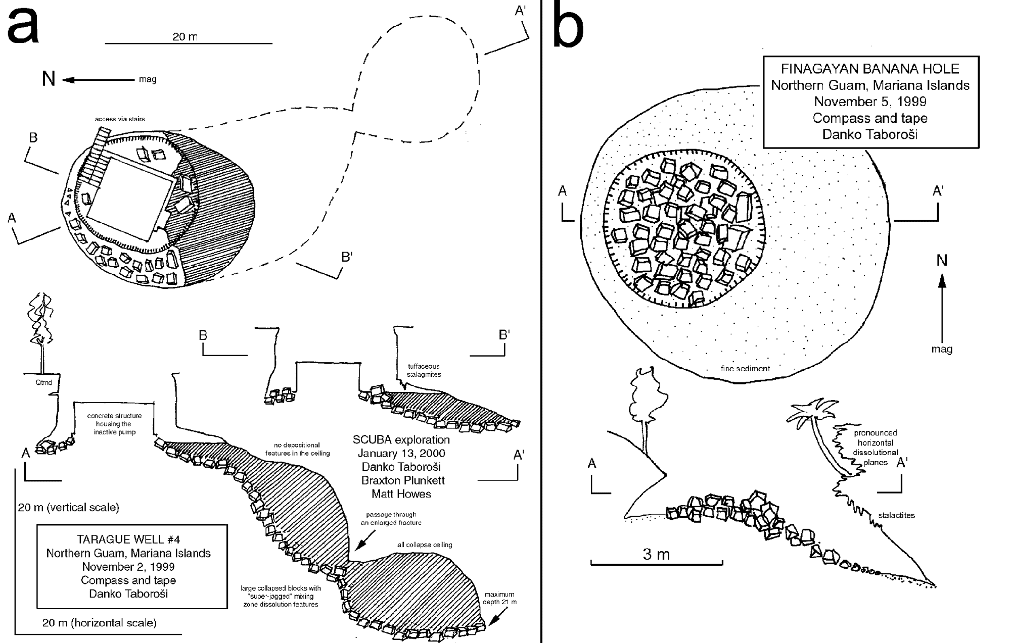
Fig. 7. Collapse sinkholes: a) Plan and profile of Tarague Natural Well #4, a vertical walled cenote formed by progradational collapse from an unknown depth; b) Plan and profile of the Finagayan banana hole, most likely formed by collapse of a shallow void formed at the top of the freshwater lens.
Deeper voids that are possibly related to the paleo-positions of the top of the freshwater lens associated with former sea level stillstands are commonly intercepted by well-drilling in the Northern Guam Lens Aquifer. A systematic examination of well logs of 119 wells in northern Guam has revealed nearly 300 cavernous zones —voids and clay pockets ( Taboro š i, 2000). Small drops of the drill are commonly reported during well drilling, and cavities up to 2 m tall are sometimes encountered. Because the horizontal extent of these voids cannot be evaluated based on well logs, their probable morphology is best observed in quarry walls, where lenticular voids can be seen isolated (Fig. 8a); or in groups forming distinct horizons (Fig. 8b), reflecting the former positions of the top of the freshwater lens. Such an arrangement is improbable for primary voids in reef rock and suggests development within the enhanced dissolution zone at the top of the lens. Well drillers have also reported voids at the top of the modern freshwater lens; and Mink, (1976) stated that during well drilling “it is not unusual to encounter cavernous limestone and the saturated zone simultaneously.”
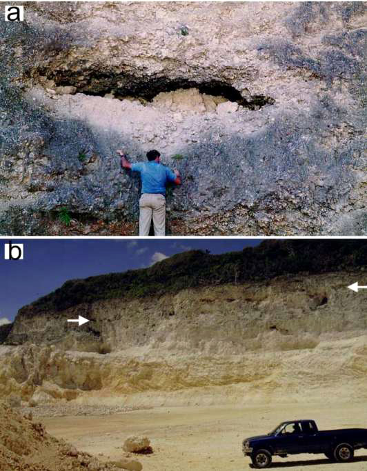
Fig. 8. Voids exposed in quarry walls: a) An isolated lenticular void, Perez Brothers Quarry, Dededo;
b) A series of voids along a distinct horizon (marked by arrows), Hawaiian Rock Quarry, Mangilao.
So far, no complex, integrated caves associated with the top of the freshwater lens have been documented on Guam. Two vertical-walled 20 m deep collapse sinkholes, Carino Sink and Barrigada Sink, contain horizontal tubular passages that may have developed as top-of-the-lens conduits during a past higher sea level stillstand, but their origin is debatable. However, indirect observations and reports from other islands indicate that such cave development does occur. For example, on Guam, a dye injected into the Finagayan banana hole was detected at the coast more than a kilometer away only 4 hours later (P. Casey, pers. comm.), indicating that apparently isolated voids, originally formed by mixing corrosion and fed by phreatic diffuse flow, can become incorporated into rapid flow networks. This probably occurs by integration of isolated voids that formed within the zone of increased horizontal porosity at the top of the groundwater lens, perhaps by action of flood waves produced by rainfall pulses. Linear horizontal passages foundering into preexisting horizontal voids have been reported from Tonga (Lowe & Gunn, 1986; Gunn & Lowe, 1999), and long tubular caves associated with the top of the phreatic zone have been described by Ollier (1975) in the Trobriand Islands.
Base of the lens
The freshwater lens and the underlying marine groundwater are distinct bodies of water, separated by differences in density. The boundary between the two can be sharp, with salinity changing from fresh to marine over a vertical distance of millimeters to centimeters, and in which case it is known as the halocline, or it can be dispersed, with the same change occurring over a vertical distance of meters or tens of meters, in which case it is known as the mixing zone (Mylroie and Carew, 1997) (Fig. 2). Freshwater and saline water mixing produces brackish water with significant dissolution potential (Plummer, 1975; Smart et al., 1988), which can be further increased by the oxidation of organic material collecting at the associated pycnocline (density boundary) (Bottrell et al., 1991).
Except in the distal margin of the freshwater lens, which coincides with the coastline and is discussed in the next section, caves forming at the base of the freshwater lens are rarely reported and difficult to investigate. No uplifted cave in the vadose zone of carbonate islands has been unequivocally linked to dissolution at the halocline, although the Tumwalau type caves of Ollier (1975) are thought to have formed in the lower part of a freshwater lens (Gunn and Lowe, 1999). In the Bahamas, divers have reported void development along the modern halocline (Palmer and Williams, 1984). In northern Guam, halocline caves have not been observed, although unusual linear caves extending from the ocean into the island's interior are sometimes seen by divers. The longest cave of this type is Matt's Cave, entered through a 2-m diameter opening located at a depth of 50 m in Palace Wall — a fringing reef wall near the Palace Hotel in Tamuning. This submarine cave is now inactive, as it lays deep below the modern halocline and freshwater lens. It consists of a single, subhorizontal linear passage perpendicular to the coastline. It has been explored to a distance of over 200 m, where it reaches a depth of 65 m.
Lens distal margin
The freshwater lens is in a dynamic equilibrium of recharge and discharge. The discharge from the lens occurs along its distal margin, i.e. the island's perimeter, where the lens is the thinnest and the two primary areas of enhanced dissolution in the freshwater lens — its top and its bottom — converge (Fig. 2). This greatly increases dissolution (Mylroie and Carew, 1995a; Mylroie et al., 1995a), which is further enhanced by the oxidation of organic material accumulating at the associated pycnoclines (Mylroie and Balcerzak, 1992). Because water captured by the entire island's area is all discharged along the island's perimeter, the specific discharge in the coastal area is greater than in inland areas, thus causing a further intensification of speleogenesis in the distal (active) margin of the lens (Raeisi and Mylroie, 1995). Prototypical caves in the lens' active margin are termed flank margin caves (Mylroie and Carew, 1990). They form through mixing dissolution, where diffuse water flow converges to form mixing chambers. Recently, caves associated with turbulent water flow, focused within dissolutionaly-enlarged fractures, have also been documented in this area of the freshwater lens ( Taboro š i, 2000). These unusual caves are discussed in the last paragraph of this section.
Flank margin caves, which form in the mixing zone of the active edge of the freshwater lens, are usually the dominant caves on carbonate islands, in terms of both size and number. Their nature as mixing chambers and sites of preferential diffuse flow — rather than conduits — results in idiosyncratic morphology. They are typically horizontally broad but vertically restricted, and consist of large (10s of meters), oblate to spheroidal chambers that are separated by thin bedrock spans and may branch out into short tubular passages that end abruptly (Mylroie et al. , 1995b). Because they receive and discharge water by diffuse flow, they are neither open to the surface nor the ocean, and lack stream channels, ablation scallops, and other features associated with turbulent flow (Mylroie and Carew, 1995a). Flank margin caves, which necessarily form under phreatic conditions can be placed into the vadose zone by island uplift or sea-level lowering, and can be subsequently breached by erosion and collapse.
Flank margin caves are ubiquitous in the coastal cliffs of northern Guam, where they are found at elevations as high as 150 m above the modern sea level. They are commonly found aligned along horizons, indicating paleo-positions of the freshwater lens' active edge, associated with past glacioeustatic sea level stillstands. The simplest of such caves are single voids breached by cliff retreat: they are vertically limited and extend from the cliffside openings inland to smaller chambers, which abruptly pinch off. Their maximum penetration length perpendicular to the shoreline is typically 10-30 m, and can be as small as a few meters, in cases where caves have been all but obliterated by cliff erosion (Fig. 9). The walls and ceilings of flank margin caves are dominated by phreatic dissolution surfaces, phreatic cusps (Frank et al. , 1998) and other smooth, curvilinear features. Speleothems can be present, but are often grotesquely dissolved by phreatic dissolution, illustrating the complex sea level changes that Guam has experienced. Unlike the cliff-side flank margin caves that are opened by cliff retreat, flank margin caves that are located on the coastal terraces and the bases of cliffs are frequently opened by ceiling collapse. They also exhibit typical flank margin cave morphology. Pagat Cave (Fig. 10), for example, is an archetypal flank margin cave that is set in a coastal terrace 300 m from the sea. It consists of a series of vertically limited phreatic chambers, intersecting the freshwater lens and leading to no passages – submerged or subaerial. However, many caves in a similar setting exhibit certain departures from the standard model. For example, Marbo Cave, Fadian Cave, Frankie's Cave, and Fafai Cave (Fig. 11), all exhibit features that set them apart from the ideal flank margin cave model. These unusual characteristics include a large vertical extent; floors composed of collapsed rubble, rather than bedrock; apparently extensive submerged passages; and conspicuous locations just inland from major coastal point discharge points. Although generally lacking traversable connections with the ocean, the caves' freshwater pools are inhabited by amphidromous stygophiles, such as dusky sleeper fish ( Eleotris fusca ) and Tahitian prawn ( Macrobrachium lar ), indicating that connections with the ocean, which are necessary for these organisms to complete their life cycle, do exist. Most surprisingly and in contrast with the flank margin caves, which form by diffuse flow, some coastal caves on Guam are associated with conduit flow and contain prolific coastal springs (Fig. 12). They appear to be termini of conduit systems, and their formation mechanisms are still poorly known and not well explained by the current conceptual models of karst on islands. The most voluminous spring in northern Guam emerges from one such cave ( Coconut Crab Cave, Fig. 13), and discharges an estimated 0.225 m 3 /s of freshwater into the ocean (Jocson, 1998). Several other caves, where no water flow or discharge can be visually observed, have been suggested to conduct conduit flow, based on the data produced by natural potential anomaly surveys (Lange and Barner, 1995).
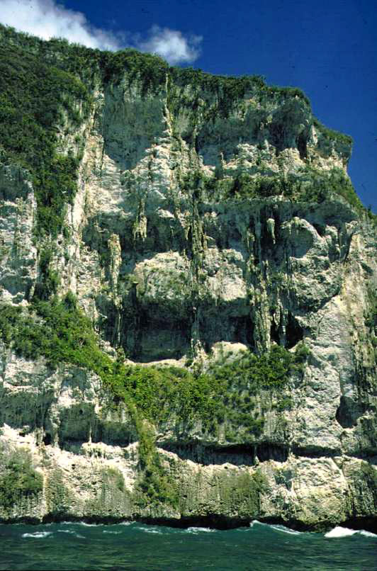
Fig. 9. The 80-m tall Amantes Point cliff. N ote the four horizons of cave development above the modern sea level. Cliff erosion has nearly obliterated the caves, still evidenced by partial chamber morphology and the massive speleothem deposits. Modern marine notch is visible at sea level.
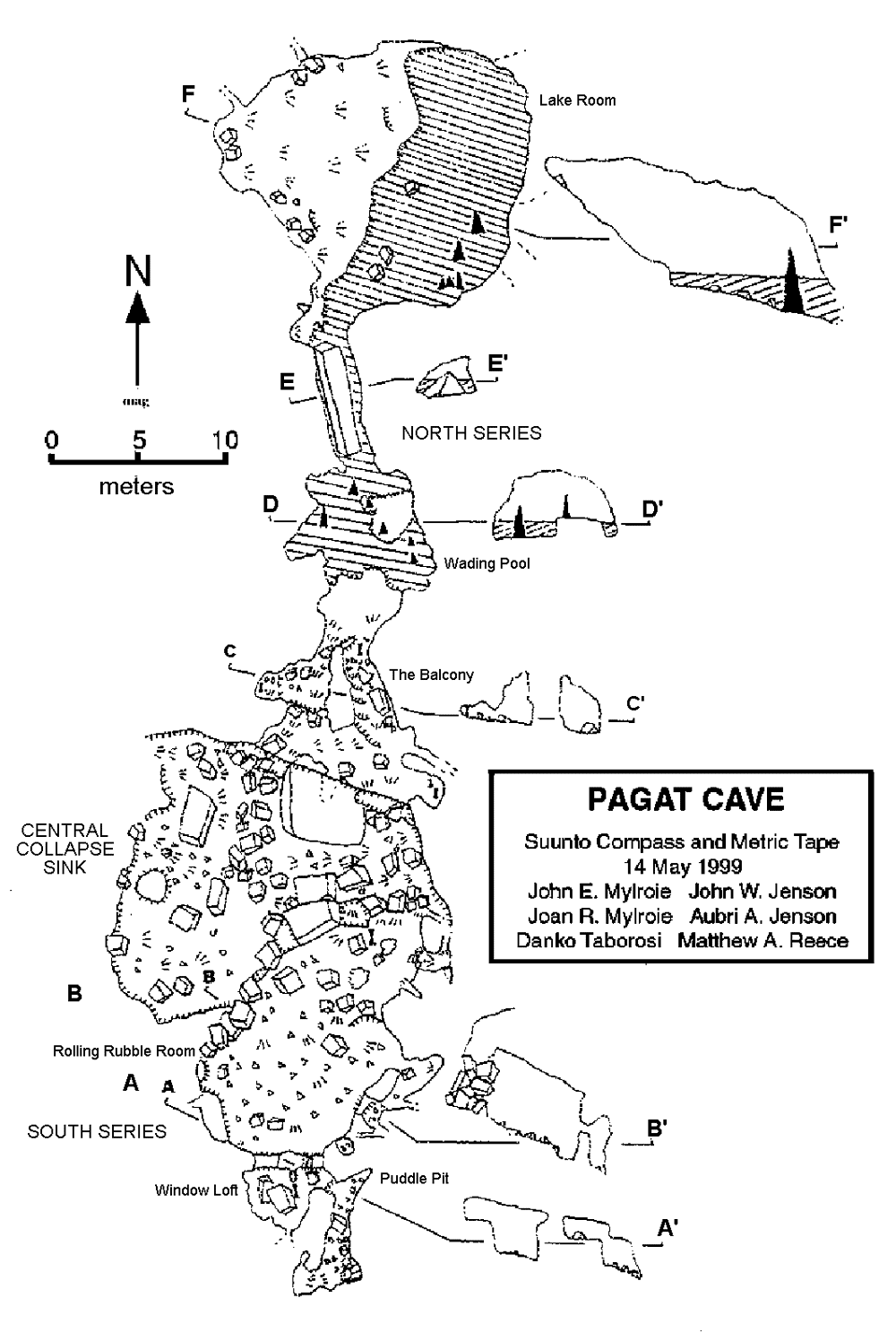
Fig. 10. Plan of Pagat Cave – a coastal cave showing typical flank margin features, including large chambers that abruptly end, phreatic dissolution surfaces, and a north-south orientation, paralleling the nearby coastline. Map by John E. Mylroie (Mylroie et al., 2001).
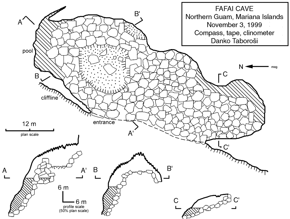
F ig. 11. Plan and profiles of Fafai Cave – a coastal cave showing departures from the flank margin cave model, including large vertical extent, apparent progradational collapse from an unknown depth, possible submerged passages, and connections to nearby prolific coastal springs.
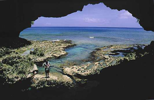
Fig. 12. Natural Arch Spring in Double Reef area, northern Guam. The arch is a remnant of a coastal cave roof nearly destroyed by collapse. The freshwater discharges from the narrow channel visible to the right of the standing person and feeds into the ocean. The freshwater seems to have caused the prominent interruption in the coastal algal terrace, either through dissolution or prevention of its growth.
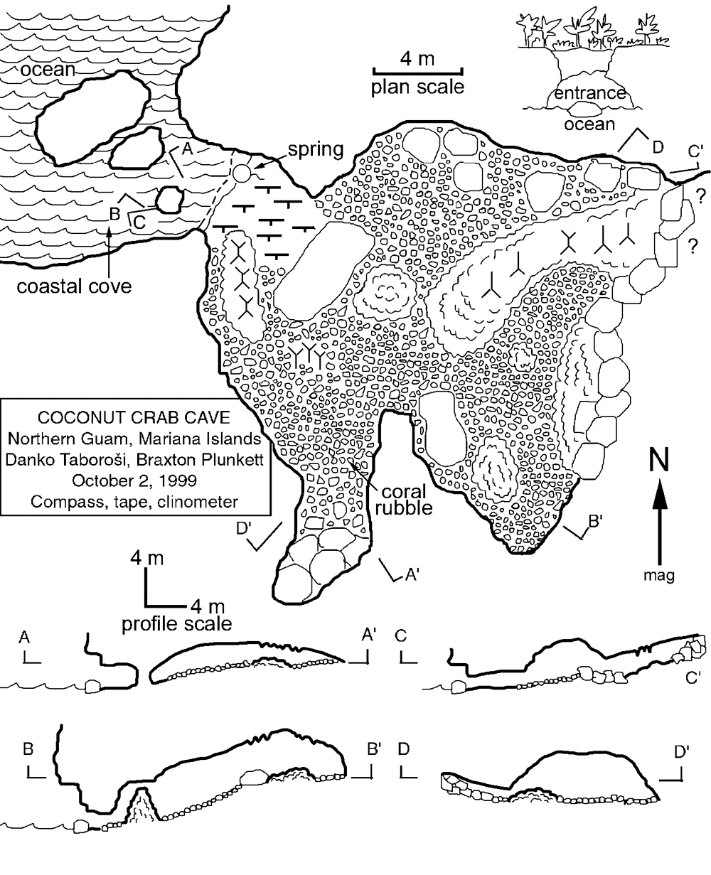
Fig. 13. Plan and profiles of Coconut Crab Cave. Note the location of the spring in the cave entrance, at the sea level.
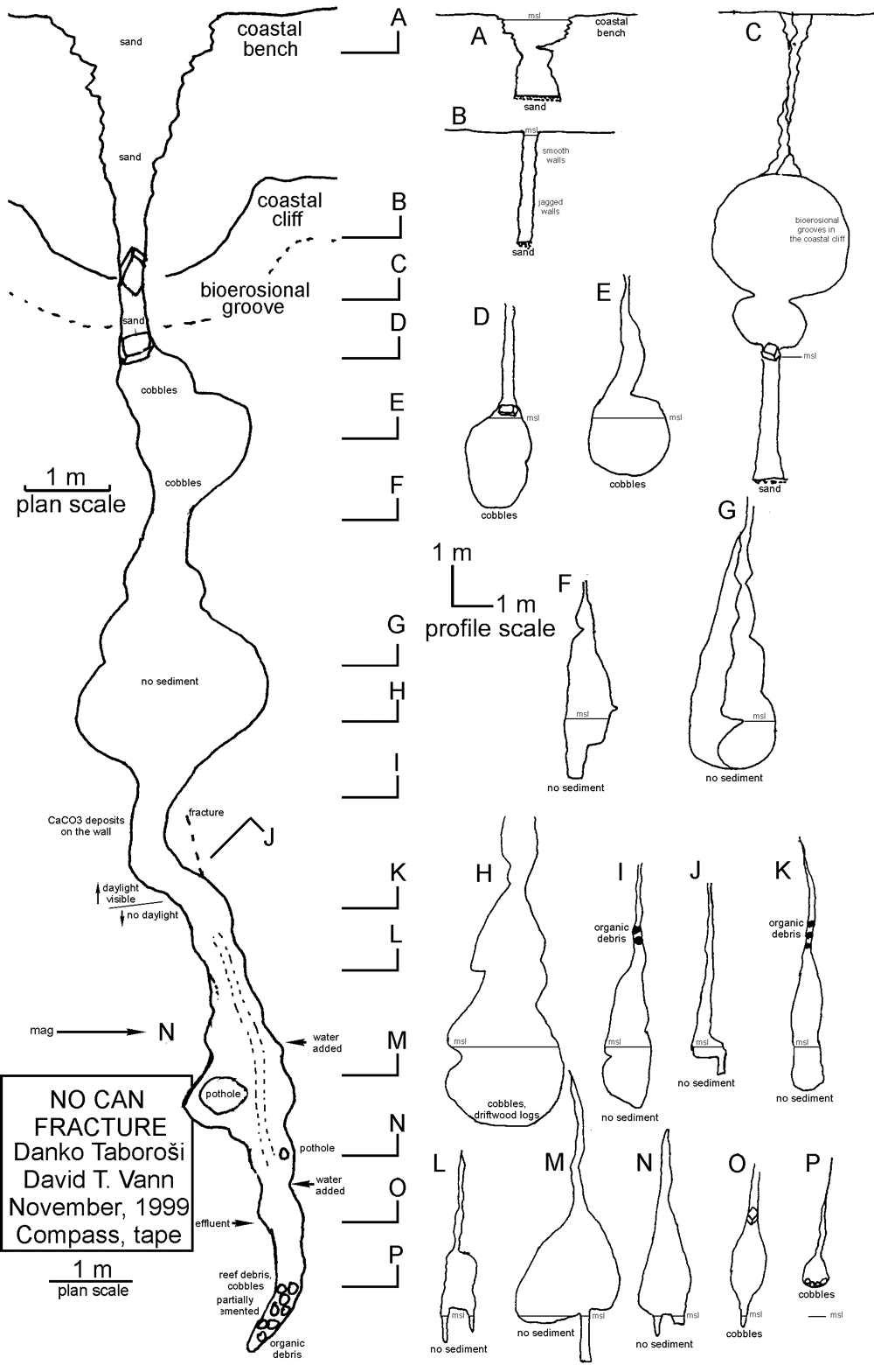
Fig. 14. No Can Fracture – a vadose canyon discharging a stream of freshwater underlain by saltwater.
Departing from the original flank margin model based on examples from the tectonically quiescent Bahamas and Isla de Mona (Mylroie et al., 1995b), these unusual caves could be flank margin caves modified by unique geologic and hydrologic conditions on Guam. Their large vertical extent could be the result of a formation concurrent with rapid uplift that Guam has experienced. Other characteristics, including connections with the ocean and possible conduit flow, could be a result of cave breakdown and the capturing of conduit flow subsequent to cave inception. However, there are other possible modes of origin, fringing on the flank margin model that should be considered. These caves could be sort of transitional features between flank margin caves and conduits, such as those reported in the Yucatan by Smart et al. (2002) ; or they could be the result of the progradational collapse of voids from the basement-limestone contact, as reported from Bermuda (Mylroie et al., 1995a), which may have intercepted flank margin caves during the collapse process.
Finally, there is a group of coastal caves at Double Reef, northern Guam, which have, indeed, developed as conduits and are, arguably, the most interesting and unique type of caves on the island. They are dissolution-widened vertical fractures, up to several meters wide, opening up in the coastal cliffs and discharging free-surface freshwater streams, which are underlain by seawater, into the ocean. They are thus analogous to vadose canyons, but have seawater, instead of rock, providing the base for freshwater flow. In the largest fractures – those with an estimated discharge of up to 0.1 m 3 /s and flow velocities up to 0.5 m/s (Jocson, 1998) – the water flowing at the surface is fresh, and depth to contact with the underlying seawater can be up to 1 m (Gamble et al. , 2002). Sufficiently widened fractures, such as No Can Fracture (Fig. 14) and Menpachi Fracture, can be entered through their openings in the coastal cliffs. At their widest points ![]() – generally at or below the modern sea level – the width of fractures ranges from 0.5 m to several meters and generally decreases upward, closing to millimeter width within 3-9 m above the modern sea level; the non-widened portions continue up to the epikarst and the ground surface. The se caves appear to form by widening of fractures by aggressive water discharging at sea level. The main dissolution front is probably at the halocline or right above it and vertically migrates with sea level changes. Analogous features have recently been discovered on Tinian (Stafford et al., 2003b), and probably occur on other carbonate islands, where they may have been overlooked by speleologists.
– generally at or below the modern sea level – the width of fractures ranges from 0.5 m to several meters and generally decreases upward, closing to millimeter width within 3-9 m above the modern sea level; the non-widened portions continue up to the epikarst and the ground surface. The se caves appear to form by widening of fractures by aggressive water discharging at sea level. The main dissolution front is probably at the halocline or right above it and vertically migrates with sea level changes. Analogous features have recently been discovered on Tinian (Stafford et al., 2003b), and probably occur on other carbonate islands, where they may have been overlooked by speleologists.
Lens inner margin
Speleogenesis by vadose water moving along the carbonate-basement contact has already been discussed, but what happens when this water reaches the freshwater lens remains to be considered. Caves that develop along the vadose carbonate-basement contact are conduits capable of delivering meteoric water straight to the phreatic zone. This water is likely to remain highly aggressive, even when it reaches the groundwater level. This occurs because its journey through the vadose zone is largely via passages incised in volcanic basement units and its contact with the limestone is, thereby, limited. When it reaches the top of the phreatic zone, this water, which arrives mostly in flood waves produced by storms, accumulates and enters the openings in the surrounding bedrock, rapidly enlarging them and forming caves that serve as floodwater storage (Palmer, 2001). Even if the water arriving to this zone loses its dissolution potential during its downward journey, its aggressiveness could be renewed by mixing with the phreatic freshwater in the lens, as well as by the oxidation of organic materials, brought in by floodwaters. The area where all this occurs is the portion of the freshwater lens that is in contact with the non-carbonate basement units (Fig. 2). It can be termed the inner or the contact margin of the freshwater lens, as opposed to the distal or the active margin of the lens (Raeisi and Mylroie, 1995), which coincides with the coastline.
So far, no caves on carbonate islands have been unequivocally linked to speleogenesis within the inner margin of the freshwater lens. Their development is only hypothesized. On Guam, none of the basement conduit caves can be followed to the current inner margin of the freshwater lens, but there is some evidence of caves associated with its higher paleo-positions. This is reflected in the unusual morphology of Awesome Cave (Mylroie et al., 2001). Located on the flank of Mt. Santa Rosa, this cave is an active vadose canyon that follows the contact between basement volcanic terrain and the overlying limestone. Awesome Cave is remarkable because it contains large chambers that have not formed by the collapse of an underlying active passage (as in Piggy Cave, Fig. 5b), but by phreatic dissolution (Fig. 15). The chambers overlay the active stream passage and are up to 20 m wide and 8 m tall, forming a series descending in a step-like fashion. Their ceilings are generally subparallel to the floor and are characterized by well-developed phreatic dissolution features, including phreatic cusps that smoothly cut across bedrock, paleosol, and breccia. The ceiling of the lowest chamber is completely horizontal and flat – almost entirely a smooth phreatic dissolution surface that is interrupted by several collapse scars. All this indicates that the chambers have formed in a phreatic setting, either flood-induced or within the freshwater lens. The floors of the rooms are composed of rock rubble, mud, flowstone, and rimstone pool series, and have collapsed in two places, providing access to the active vadose canyon passage below. The active passage can be followed upstream towards the swallow-hole for approximately 35 m, where it is closed by a siphon; and nearly 100 m downstream, until it becomes too narrow to pursue. It is joined by a tributary vadose stream ( Interesting Cave ), which can be followed back to its swallow-hole at the surface. While the active passages of these caves are vadose canyons, formed by aggressive water moving along the carbonate-basement contact, the large chambers of Awesome Cave appear to have formed by phreatic dissolution at the top of the freshwater lens, during past higher sea levels. Their step-like arrangement possibly reflects different relative sea-level stillstands. However, their origins are still debatable: they could also be the result of floodwater ponding, which is sometimes responsible for features attributed to slow phreatic flow or mixing zone dissolution (Palmer, 2001).

Fig. 15. Profile of Awesome Cave – a stream cave overlain by large phreatic chambers, which may have formed within the lens inner margin during former higher sea level stillstands.
Conclusions
High primary porosity of the young limestones of the Northern Guam Lens Aquifer causes the solutional attack by meteoric water to be diffused, precluding the focusing of aggressive water necessary to produce most caves. Nevertheless, extensive speleogenesis does occur, albeit it is limited to hydrologic or geologic boundaries that can provide basis for enhanced dissolution (Mylroie et al., 1999; Vacher and Mylroie, 2002). In the vadose zone, these boundaries are geologic contacts or structures that focus the flow of aggressive water; while in the phreatic zone, the boundaries are hydrologic contacts, which produce aggressive water through the mixing of saturated waters.
Seven zones of extensive speleogenesis have been recognized in northern Guam. E ach of these geologic and hydrologic environments exhibits caves of characteristic morphology and hydrologic properties. Documenting the relationship between these zones and the types of associated caves is crucial to accurate conceptual modeling of island karst aquifers and the successful development and management of their freshwater resources. It is also needed for accurately interpreting former speleogenetic and hydrologic environments, investigating geologic history of carbonate islands, and understanding the paleodynamics of their aquifers.
Acknowledgements
This research is part of a project funded by the U.S. Geological Survey, Water Resources Division, through the Water Resources Research Institute, Regional Competitive Award Program, award number 1434-HQ-96-GR-02665. Initial work was also supported by the Guam Hydrologic Survey Program of the Water and Environmental Research Institute of the Western Pacific (WERI), University of Guam, which was initiated by the 24 th Guam Legislature. We are grateful to David Vann, Curt Wexel, John Jocson, and graduate students at WERI for invaluable support in the field. We are also indebted to all the authors who have sent us reprints of their papers.
References
- Ayers J. F. and Clayshulte R. N. 1984. A preliminary study of the hydrogeology of northern Guam (WERI Technical Report 56). Mangilao, Guam, Water and Energy Research Institute of the Western Pacific, University of Guam.
- Bögli A. 1964. Mischungkorrosion; ein Beitrag zum Verkarstungsproblem. Erdkunde 18(2), 83-92.
- Bottrell S. H., Smart P. L., Whitaker F. and Raiswell R. 1991. Geochemistry and isotope systematics of sulphur in the mixing zone of Bahamian blue holes. Applied Geochemistry 6, 99-103.
- CDM. 1982. Final Report, Northern Guam Lens Study. Agana, Guam, Camp, Dresser and McKee, Inc. in association with Barrett, Harris and Associates for the Guam Environmental Protection Agency.
- Contractor D. N. 1983. Numerical modeling of saltwater intrusion in the Northern Guam Lens. Water Resources Bulletin 19, 745-751.
- Dasher G. R. 1994. On Station - A Complete Handbook for Surveying and Mapping Caves. Huntsville, Alabama, National Speleological Society, 242 p.
- Ford D. C. and Williams P. W. 1989. Karst geomorphology and hydrology. Winchester, Massachusetts, Unwin Hyman, Inc., 320 p.
- Frank E. F., Mylroie J., Troester J., Alexander E. C. and Carew J. L. 1998. Karst development and speleogenesis, Isla de Mona, Puerto Rico. Journal of Cave and Karst Studies 60(2), 73-83.
- Gamble D. W., Taboro š i D., Mylroie J. E., Jenson J. W., Carew J. L., Jocson J. M. U., Mylroie J. R. and Vann D. T. 2002. The use of water temperature to characterize groundwater discharge of a coastal fracture on Guam, USA. Journal of Coastal Research (in press).
- Gunn J. and Lowe D. J. 1999. Speleogenesis on tectonically active carbonate islands. In : Klimchouk A. B., Ford D. C., Palmer A. N. and Dreybrodt W. ( Eds). Speleogenesis: Evolution of Karst Aquifers. Huntsville, Alabama, National Speleological Society, 238-243.
- Harris J. G., Mylroie J. E. and Carew J. L. 1995. Banana holes: unique karst features of the Bahamas. Carbonates and Evaporites 10(2), 215-224.
- Jenson J.W., Jocson J.M.U. and Siegrist H.G. 1997. Groundwater discharge styles from an uplifted Pleistocene island karst aquifer, Guam, Mariana Islands. In: Beck B.F. and Stephenson J.B. (Eds.) The Engineering Geology and Hydrology of Karst Terranes. Springfield, Missouri, Balkema, 15-19.
- Jennings J. N. 1985. Cave and Karst Terminology. In : Matthews P. G. (Ed.) Australian Karst Index 1985 , Australian Speleological Federation, 1-13.
- Jocson J. M. U. 1998. Hydrologic model for the Yigo-Tumon and Finegayan subbasins of the Northern Guam Lens Aquifer, Guam. Masters Thesis University of Guam, 95 p.
- Lander M. A. 1994. Meteorological factors associated with drought on Guam (WERI Technical Report 75). Mangilao, Guam, Water and Energy Research Institute of the Western Pacific, University of Guam, 39 p.
- Lange A. L. and Barner W. L. 1995. Application of the natural electric field for detecting karst conduits on Guam. In : Beck B. F. (Ed.) Karst GeoHazards , Rotterdam, Balkema, 425-441.
- Lowe D. J. and Gunn J. 1986. Caves and limestones of the islands of Tongatapu and 'Eua, Kingdom of Tonga. British Cave Research Association Transactions 13(3), 105-130.
- Mink J. F. 1976. Groundwater resources on Guam : Occurrence and Development (WERI Technical Report 1). Mangilao, Guam, Water and Energy Research Institute of the Western Pacific, University of Guam, 276 p.
- Mylroie J. E. 1984. Hydrologic classification of caves and karst. In : LaFleur R. G. (Ed.) Groundwater as a geomorphic agent , Boston, Allen and Unwin, 157-172.
- Mylroie J. E. and Balcerzak W. J. 1992. Interaction of microbiology and karst processes in Quaternary carbonate island aquifers. In : Stanford J. A. and Simons J. J. (Eds.) Proceedings of the First International Conference on Ground Water Ecology , Bethesda, Maryland, American Water Resources Association, 37-46.
- Mylroie J. E. and Carew J. L. 1990. The flank margin model for dissolution cave development in carbonate platforms. Earth Surface Processes and Landforms 15, 413-424.
- Mylroie J. E. and Carew J. L. 1995a. Chapter 3: Karst development on carbonate islands. In : Budd D. A., Harris P.M. and Saller A. (Eds.) Unconformities and Porosity in Carbonate Strata , Tulsa, Oklahoma, American Association of Petroleum Geologists, 55-76.
- Mylroie J. E. and Carew J. L. 1995b. Geology and Karst Geomorphology of San Salvador Island, Bahamas. Carbonates and Evaporites 10(2), 193-206.
- Mylroie J. E. and Carew J. L. 1997. Land use and carbonate island karst. In : Beck B. F. and Stephenson J. B. ( Eds.) The Engineering Geology and Hydrogeology of Karst Terranes , Rotterdam, Balkema, 3-19.
- Mylroie J. M. and Jenson J. W. 2000. CIKM, the Carbonate Island Karst Model. Geological Society of America Abstracts with Programs 32(7), A-355.
- Mylroie J.E. and Vacher H.L. 1999. A conceptual view of carbonate island karst. In : Palmer A. N., Palmer M. V. and Sasowsky I. D. (Eds.) Karst Modeling Symposium , Charlottesville, Virginia, Karst Waters Institute, 48-57.
- Mylroie J. E., Carew J. L. and Vacher H. L. 1995a. Karst development in the Bahamas and Bermuda. In : Curran H. A. and White B., eds. Terrestrial and Shallow Marine Geology of the Bahamas and Bermuda, Geological Society of America special paper 300, 251-267.
- Mylroie J. E., Carew J.L., Frank E.F., Panuska B.C., Taggart B.E., Troester J.W. and Carrasquillo R. 1995b. Development of flank margin caves on San Salvador Island, Bahamas and Isla de Mona, Puerto Rico. In : Seventh Symposium on the Geology of the Bahamas , San Salvador Island, Bahamas, Bahamian Field Station, 49-81.
- Mylroie J. E., Jenson J. W., Jocson J. M. U. and Lander M. 1999. Karst Geology and Hydrology of Guam : A Preliminary Report (WERI Technical Report 89). Mangilao, Guam, Water and Energy Research Institute of the Western Pacific, University of Guam, 32 p.
- Mylroie J. E., Jenson J. W., Taboro š i D., Jocson J. M. U., Vann D. T. and Wexel C. 2001. Karst Features of Guam in Terms of a General Model of Carbonate Island Karst. Journal of Cave and Karst Studies 63(1), 9-22.
- Ollier C. D. 1975. Coral island geomorphology – the Trobriand islands. Zeitschrift für Geomorphologie 19, 164-190.
- Palmer A. N. 1991. Origin and morphology of limestone caves. Geological Society of America Bulletin 103, 1-21.
- Palmer A. N. 2001. Dynamics of cave development by allogenic water. Acta Carsologica 30(2), 13-32.
- Palmer R. and Williams D. W. 1984. Cave development under Andros Island, Bahamas. Cave Science 13, 79-82.
- Plummer L. N. 1975. Mixing of sea water with calcium carbonate ground water. In : Whitten, E. H. T. (Ed.) Quantitative studies in geological sciences , Boulder, Colorado, Geological Society of America, 219-236.
- Raeisi E. and Mylroie J. E. 1995. Hydrodynamic behavior of caves formed in the fresh-water lens of carbonate islands. Carbonates and Evaporites 10(2), 207-214.
- Reagan M. K. and Meijer A. 1984. Geology and geochemistry of early arc-volcanic rocks from Guam. Geological Society of America Bulletin 95, 701-713.
- Smart P. L., Beddows P., Doerr S., Smith S. and Whitaker F. F. 2002. Hydrochemical processes and cave development, Caribbean Coast, Yucatan Peninsula, Mexico. In : Martin J. B., Wicks C. M. and Sasowsky I. D. (Eds.) Hydrogeology and Biology of Post-Paleozoic Carbonate Aquifers, Proceedings of the symposium Karst Frontiers: Florida and Related Environments , Gainesville, Florida, Karst Waters Institute, 79-83.
- Smart P. L., Dawans J. M. and Whitaker F. 1988. Carbonate dissolution in a modern mixing zone. Nature 335, 811-813.
- Stafford K.W., Mylroie J.E., Mylroie J.R., and Jenson J.W. 2003a. Tinian, CNMI: A carbonate island karst model evaluation. Geological Society of America Abstracts and Programs 35-1, 3.
- Stafford K. W., Mylroie J. E., Taboro š i D., Mylroie, J. R., Keel T. M. and Jenson J. W. 2003b. Structurally controlled eogenetic karst: Mariana Islands. Geological Society of America abstracts with programs 34-7, 452.
- Taboro š i D. 1999. An inventory of karst features on Guam. In : Palmer A. N., Palmer M. V. and Sasowsky I. D. (Eds.) Karst Modeling Symposium , Charlottesville, Virginia, Karst Waters Institute, 244.
- Taboro š i D. 2000. Karst features on Guam. Masters Thesis University of Guam, 324 p.
- Tracey J. I., Jr., Schlanger S. O., Stark J. T., Doan D. B. and May H. G. 1964. General Geology of Guam. U.S. Geological Survey Professional Paper 403-A. Boulder, Colorado, United States Geological Survey, 104 p.
- UNU. 1995. Small Islands , Big Issues: Crucial issues in the sustainable development of small developing islands. Helsinki, The United Nations University World Institute for Development Economics Research, 172 p.
- Vacher H. L. 1988. Dupiut-Ghyben-Herzberg analysis of strip-island lenses. Geological Society of America Bulletin 100, 850-591.
- Vacher H.L. 1997. Introduction: Varieties of carbonate islands and a historical perspective. In : Vacher H. L. and Quinn T. M. (Eds.) Geology and hydrogeology of carbonate islands, Developments in Sedimentology 54. Amsterdam, Elsevier Science Publishers, 1-33.
- Vacher H. L. and Mylroie J. E. 2002. Eogenetic karst from the perspective of an equivalent porous medium. Carbonates and Evaporites 17(2), 182-196.
- Vann D. In prep. Basement Volcanic Map Revisions for the Northern Guam Lens Aquifer Using GIS. Masters Thesis University of Guam.