France Šušteršič
Collapse Dolines, Deflector Faults and Collector Channels
Dept. of Geology NTF, University of Ljubljana, SI-1001, Ljubljana, Askerceva 12, Slovenia. E-mail: This email address is being protected from spambots. You need JavaScript enabled to view it.
Abstract
In some Slovenian caves collector channels gather sinking underground streams and redirect them for potentially long distances parallel to certain faults. They formed due to permanent collapse of cave roofs at the points where they break through the faults, which function as a kind of screen and are termed deflector faults. The fault trends are marked by collapse within the caves, and by active collapse dolines at the surface.
Keywords by author: speleogenesis, collector channel, deflector fault, collapse, collapse doline, karst of Slovenia
Introduction
Klimchouk and Ford (2000, p.47) wrote: “Speleogenesis can be viewed as the creation and evolution of organized permeability structures in a rock that have developed as the result of dissolutional enlargement of an earlier porosity.” In the same volume Lauritzen and Lundberg (2000, pp.408-409) added to the same idea (in slightly different order): “In the strict sense (sensu stricto), ‘speleogenesis’ means the creation of a cave from ‘scratch’.” … “Once speleogensis has established the gross geometry of cave system…” … “When discussing the shape of caves, it is practical to distinguish between mesoforms, that are similar size to the diameter of the cave passage itself, and microforms, that are smaller than the passage.” … “Meso- and microforms are controlled by corrosive and erosive processes (active variables) but have lithologic and tectonic constraints (passive variables)1 . Geology influences passage form through control of…”
This raises some questions:
- What is “the gross geometry of a cave system”, and/or what (perhaps) are macroforms?
- What controls the development of the gross geometry of a cave system or, in other words, the structure of the cave system, and how is this achieved?
- Does a conduit pattern simply adjust itself to the constraints imposed by passive variables, or does it react actively to the various situations that may appear during development?
When searching for the answer to the first question, it becomes self evident that the formation of a conduit system proceeds on two logical levels:
“conduit” – genesis ![]() Bringing about the shape of a particular structural segment (mesoforms and microforms)
Bringing about the shape of a particular structural segment (mesoforms and microforms)
“cave network” - genesis ![]() Bringing about specific spatial arrangement of structural segments
Bringing about specific spatial arrangement of structural segments
In this context, the latter notion appears to be the answer to the first question.
The former aspect has been extensively clarified during the last decade, and the book edited by Klimchouk et al. (2000) provides very convincing proof of this. On the other hand, the latter logical level has been rather less elaborated. Palmer (2000), however, demonstrated that cave pattern develops under direct and predictable control of general hydrogeological circumstances what typically belong to active factors (variables) in the sense of previous discussion. As concerning the passive control, most researchers appear to believe that, within the borders of the aquifer, at the scale of a square kilometre or so, evolution proceeds straightforwardly from privileged fissures towards the conduit pattern. The process of selection and linking is viewed as being passive and quite locally conditioned; thus it is somehow random or at least hardly predictable. If there has been any search for prediction, it appears that the answer has been sought in the realm of the greater/lower transmissivity of growing channels. Hardware, and more recently, digital modeling (Gabrovsek, 2000) seem to have tackled the question of cave system development more directly.
Recent study of “active” collapse dolines (Šušteršič, 1997; 2000b), and of the role of “deflector faults” and “collector channels” (Šušteršič et al., 2001), revealed that:
• processes intrinsic to (some) cave systems bring about predictable organization of conduit networks;
• these processes are partly reflected at the surface.
Looking at the actual geological setting it is possible to predict the pattern of the caves from the initial geological conditions. With enough field information, plus an understanding of the geologic history of the region, it should be possible to predict where caves will form (or at least explain why they formed where they did).
Starting ideas
Larger scale karst subsidence phenomena, known generically as collapse dolines (Cramer, 1944, p.327), would appear to be the most likely surface karst features to give direct information about underground development. By reference to the example of Rakovska kukava, Šušteršič (1997) demonstrated that very large collapse dolines can evolve from relatively small cave chambers (type O2, Šušteršič, 2000b, p.222, Fig.4). Detailed study of the doline’s morphology revealed that its volume (1.35Mm3) and its present shape are predominantly the result of the simple settling down of tectonic crush within the shatter zone of a local strike-slip fault, plus slope processes. The explanation is that underground water finds such zones difficult to break through. Consequently, once such a route was opened, flow along it would persist, even if the passage were repeatedly obstructed by periodic collapse of tectonic crush. This process would continue until the water could no longer cope with the increasing input of collapse material originating from the expanding doline slopes. Such dolines are described as active. Then the river would have to find another breakthrough location, which would be similarly unstable.
The impressive volumes2 of some active collapse dolines, exceeding the possible volume of any cave chamber by many times, give an impression that they are a product of rather obscure, long term, processes. Additionally, measurements of water hardness on the upstream and downstream sides of some collapse dolines yielded no noticeable differences, so that processes other than corrosion of the broken down rock were sought (Šušteršič, 1997).
The rate of mass removal from the base of the collapse doline due to corrosion of collapse material can be expressed by the equation:

Where:
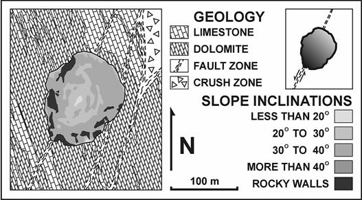
Fig.1. Ground plan of Rakovska Kukava. Note the concentric band of increased slope inclination around the centre, due to post-Würmian removal of the base of the screes.
During the cold periods of the Pleistocene the production of collapse material and gravel on slopes exceeded the undercutting in Rakovska kukava (Šušteršič, o.c.), whereas in warmer periods the situation was/is opposite. So, in the centre of the doline there is a clearly distinguishable post-Wurmian subsidence cone (Fig.1). General knowledge of the hydrogeological situation permits estimation of the average discharge through the base of the doline during the Holocene. Putting these values into the formula above, one obtains:
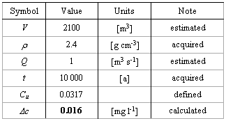
Two aspects of the result obtained (bold) must be stressed:
• minor increase in the concentration of the CaCO3 in the solution suffices to explain the observed mass deficit;
• The concentration difference is below the threshold of detection by the methods usually employed.
Moving backwards into the past one must consider at least a ten times larger discharge through the doline base before Wurm II (Šušteršič et al., 2002). So, it appears that the doline is, at the most, 640ka old. This fits well with the observation that denuded caves, occurring on the upper part of the doline’s slopes, are filled with recemented, Pleistocene, fluvial gravel. This conglomerate appears to be vaguely contemporaneous with adjacent flowstone that is too old to be dated by the U-Th series method (Šušteršič, 1998). Within the context of the present paper this means that one of the largest collapse dolines in the general area is not very old.
In 1965 Gams noticed that large cave channels run parallel to the linear margins of some Slovenian poljes, collecting water that drains perpendicular to the polje border into the karst. He termed them collector channels3 . A particularly well preserved channel on the outflow side of Cerknisko polje follows the polje margin for more than two kilometres. To the present author’s knowledge, neither Gams nor other workers have developed his ideas further.
Detailed geological mapping of cave systems and the terrains above them during the last few decades (Gospodaric 1970; Car 1982; Car and Gospodaric, 1984; Car and Sebela, 1997; Sebela 1998; Sebela and Car, 1991; Šušteršič, 1997; Šušteršič et al., 2001) has revealed a very strong connection between cave channel formation and tectonic deformation. The causal/consecutive relationships are to some extent dynamic and they may differ during particular stages of flow corridor development. Transformation of particular fault zones, induced by progressive underground and surface karstification, led to the concentration of relatively diffuse polje outlets into one master stream, parallel to the fault, and eventually to the formation of the collector channel. Thus, collector channels are an outcome of specific geospeleological conditions/development not far from the outflow polje border.
According to the authors cited above, the faults in question are of sub-regional and local dimensions. The displacements are within the range of several dozen metres. The properties of rock injured by fracturing vary characteristically. If the zone is only a few metres wide, the rock is crushed into fragments of large cobble to pebble size, and these are enclosed and supported by a matrix of generally uncemented tectonic silt. The colour is intensely red, partly due to terra rossa admixture, and partly due to the transformation of goethite into hematite, driven by tectonic stress (Zupan Hajna, 1995). On the surface these locations are generally marked by intensely vegetated stripes, by less well-expressed linear depressions or even by bogazes. According to Car (1982) such zones are virtually impermeable.
Along their length such features commonly expand to form hundred metre or so wide stripes of shattered rock. Clints or formless piles of boulders stick out of the ground. However, when hit with a geological hammer such rock, which may be highly recrystalized and interdigitated with red patches of hematite, breaks into small pieces. According to the same author such zones are highly transmissive. Sectors of both types of injury alternate quite regularly, however, in accordance with the local (palaeo-) stress field (Car and Sebela, 1997). If the zones become tectonically stable they appear to be quite prone to recementation. The alternating nature of shattered and recrystalized rock can also be detected in caves, so that it may be concluded that the alternating pattern is three-dimensional.
This paper sets out to reveal interrelationships between collector channels, the sub-regional tectonic setting and the “active” collapse dolines. It will be demonstrated that the collector channels are not just the outcome of arbitrary local conditions, but that they form under strong, though indirect, tectonic guidance. Collector channels in Postojnska jama and in Karlovice had been mentioned by Gams (o.c.), whereas the situation at Logarcek (Planinsko polje) is somewhat more complex, and has only recently been recognised.
Studied example sites
The three caves discussed in the following text are direct or indirect drains of the Postojna basin, Cerknisko polje and Planinsko polje. All of them belong to the Ljubljanica sinking river catchment, which is the main drain of the inner part of the Classical Karst of Slovenia (Šušteršič, 2000a). The Ljubljanica is widely known as a string of surface and underground stream segments, with the streams emerging into closed basins that more or less fit the traditional view of poljes. Traditionally the river is divided into two branches. The bulk of the western part encompasses the Pivka basin, which is in fact an endohoric basin predominantly on flysch (i.e. non-karstic rock) that drains underground. Nevertheless, it has many characteristics of a karst polje and thus, it has traditionally been regarded as one of them. On the other hand, the poljes of the eastern branch plus the Planinsko polje, which can be considered as the confluence of the two branches, are formed in karstic rocks. The final spring of the Ljubljanica River is a dozen kilometres north of Planinsko polje, close to Vrhnika town.
The parent bedrock in the area is predominantly Cretaceous limestone. The main tectonic structure is the Late Tertiary Idria Fault, which runs all along the eastern branch of the Ljubljanica poljes in a northwest – southeast direction. It appears, however, that the important structures in the context of the present paper are older than the Idria Fault.
Case 1: Underground flow of the Pivka (Fig.2)
Postojnska jama cave is the main drain of the Pivka basin, lying in its north-eastern corner. The system has several entrances, which have been connected during the course of exploration. Thus, particular parts of the system have their own names. Massive input of flysch gravel has brought about the formation of a cave maze on two main levels. “Dry” parts of the cave, partly modified for tourist visits, are very clearly separated from the active parts not far from the present cave entrance. Controlled much more by their actual accessibility than by the intrinsic organisation of the system, the dry passages are predominantly directed northwards. On the other hand, the active channel of the Pivka obviously turns northwestwards (Fig.2). It maintains this direction nearly without deviation for nearly a kilometre, until it reaches a depth 25m beneath the dry passage of Otoska jama. After a quarter of a kilometre, almost exactly beneath its entrance, the Pivka channel turns northeastwards.
Though very irregular in detail, the Pivka passage runs in a reasonably straight line from the ponor onwards to beneath the Otoska jama entrance. Compared to the predominantly large passages of the upper, dry, level, the active conduits, especially those closer to the bend, are narrower and lower. Incised phreatic loops can be seen at many locations, providing evidence that the channel is a product of a sinking river, laden with flysch gravel, that reshaped the initially phreatic system into an epiphreatic conduit. From the west, i.e. from the direction of the Pivka basin, a few underground tributaries join the underground river, justifying the attribution of the term collector channel (Gams, 1965, p.87 / in Slovene text only).
Parallel to and some 50-100m northeastward of the collector channel, Sebela (1998) noted a fault zone with a pervasive crushed zone. The fault has a characteristically Dinaric direction and can be traced underground as well as on the surface. Nevertheless, it is parallel to the normal contact between the limestone and the overlying flysch, so that its formation may not be attributed automatically to the “Idrian” tectonics. In the final 200m before the Pivka breaks through the obstacle, the number of locations that become siphons at higher water level, increases.
Entering the outer fault zone, the channel becomes lower and narrower. Beyond the point where the passage direction becomes perpendicular to the fault and it penetrates its inner zone, it changes to a high and wide chamber. Essentially the ceiling is less self-supporting, and fallen slabs protrude from the water. The river is still capable to remove the debris, but the rapids (Michler and Hribar 1959, p.167) indicate that it has reached the limit of its transportational/erosional capacity.
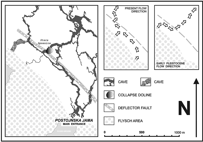
Fig.2. Geological and speleological details of the north-western sector of the Pivka basin.
When examining locations where dry passages intercept the same fault trend, similar details become evident. In the extreme south Congress Chamber lies exactly where the tourist passage crosses the fault. Thick flowstone cover indicates that the ceiling has achieved stability and blocks are no longer collapsing. The richly decorated ceiling also shows that the water that passes through it has acquired an excess of carbonate. This is obviously due to the increased surface area that the water encounters when pouring through the fault shatter zone, and perhaps also due to more abundant vegetation on the surface.
The next time the active river cave is linked to the “dry” cave is in the system of passages known as Tartarus, half a kilometre to the northwest. Tartarus consists of two main branches. The Upper Tartarus is obviously a continuation of Otoska jama, which was, in turn, the main ponor of the Pivka Basin during the Early Pleistocene (Gams, o.c.; Gospodaric, 1976). The Lower Tartarus is a swarm of narrow, labyrinth-like passages, presently connecting the Upper Tartarus with the active river cave. The nature of the passages of the Lower Tartarus indicates the difficulties that the river encountered when making its way through the broken zone. Here the flow did not persist for very long, and the span of the ceiling did not over-reach its stability.
Only a few metres beyond, where the fault zone and the large chambers of the Upper Tartarus intersect, the situation changes radically. The connection of the Upper Tartarus with the former ponor (Otoska jama) is choked by a collapse doline known as Stara Apnenica. From examination of Fig.2 (inset) it becomes evident that just before reaching the fault zone the early Pivka turned southeastwards, in a direction 180 degrees from that of the present stream, and flowed through the present Otoska jama, along the fault for about 300m. Eventually, the stream turned perpendicular to the fault zone and broke through it. The large profiles of the passages indicate that the river flowed there for quite a long time. At the breakthrough point in the core of the fault zone, the roof fell down. Eventually, this brought about formation of the collapse doline known as Stara Apnenica (Gospodaric, o.c.). Farther towards the northwest no further dry passages are known intercepting the fault zone.
Due to the varying mechanical properties of the fault, “reactions” of the cave system at its interception with the fault are different, but it is evident that, in the past as well as at present, the roles were the same. The fault zone was once such an effective obstacle that, during its geological history, it diverted the river in two opposite directions, assuming that the regional orientation of the hydraulic gradient was approximately the same throughout.
Case 2: Karlovice system (Fig.3)
At present the Karlovice system is the main outlet cave of Cerknisko polje. It is a composite of interconnected caves with separate entrances, but evidently all belonging to the same system. The total length of explored passages is about 8km and it gives an impression of a well-defined “horizontal” cave. During the last 50ka, the Cerkniscica river brought its mechanical load into the cave and filled the lower parts of the tier with sediment. At the same time “antigravitational” erosion (paragenetic erosion) cut some upward phreatic loops. Eventually the main passages acquired epiphreatic characteristics. The master string of channels, built up of segments of heterogeneous origin and oriented in various directions, runs approximately 100 to 200m away from and parallel to the ponor margin of Cerknisko polje, virtually perpendicular to the Dinaric direction. The stretch between the southern extension of Mala Karlovica cave and the Labyrinth in Velika Karlovica cave is nearly 2km long.
The polje border in this segment is predominantly precipitous (walls up to 40m high) and surprisingly straight. Whereas the former property can be explained by possible corrosional undercutting of the border of the polje (Gams, o.c.), the latter unambiguously indicates a tectonic origin.
During detailed mapping of the cave passages Gospodaric (1970) established that several minor faults guide the direction of particular structural segments. Unfortunately, due to relatively difficulty of access he could not interpret these in greater detail. Car and Gospodaric (1984) mapped the whole area between Cerknisko and Planinsko polje on the 1:5000 scale. Half a kilometre northwest from the polje border, and a few hundred metres northwest from the collector channel, they found an important cross-Dinaric fault with a wide shatter zone. Perhaps it is an equivalent of the pre-Dinaric, similarly directed faults detected in Postojnska vrata (the Postojna gap) by Car and Gospodaric (o.c.). Due to its structural, hydrogeological and speleological importance Šušteršič et al. (2001) proposed the name Karlovice Fault (Fig. 3). Even a short glance at the cave plan reveals the great influence that the fault exerted upon formation of the cave maze.
In its southeastern sector, the collector channel runs nearly straight, parallel to the fault. Several tributary passages join it from the southeast, some of them through passages accessible to humans. Towards the northwest, i.e. towards the fault, some now-abandoned channels, predominantly interrupted by frontal collapses, branch off. At its extreme northwestern extension the channel changes into a highly complex maze, which extends in both horizontal and vertical planes. Here, too, most of the passages that lead towards the fault are cut by frontal collapses. Some of the collapses extend to the surface, bringing about the formation of collapse dolines. A few of these appear even outside the known cave “influence area”, towards the northeast.
Major quantities of water, associated with the collector channel continuation, cross the fault through only two channels. The southern one conducts water into the continuation of the cave, whereas an unexplored siphon interrupts the northern one, before the fault zone can be reached. In the former, ceiling collapse marks the point where the passage touches the core of the fault zone. The absence of a larger chamber perhaps indicates that this breakthrough position is relatively recent.

Fig. 3. Geological and speleological details of the Karlovice system.
After having broken through the fault zone, the cave turns towards the west, until it encounters the frontal collapses at the base of the collapse dolines Velika Sujca and Mala Sujca (Habic, 1967; Zalec et al., 1997). The situation there is quite similar to that before the trunk channel breaks through the Karlovice Fault. Again, a wide fracture zone of an early Tertiary fault (Sujce Fault), diverting the stream northwestwards, interrupts the free drainage of the underground river. Before the meeting, in the neighbourhood of the Sujice collapse dolines, the previously united stream splits into two separate channels, and part of the southern one is labyrinth-like. Therefore, both fault zones partly impede the underground stream and deflect it away from the straight-line direction towards the resurgence in the Rakov Skocjan valley.
So, the nature of the obstacles becomes clear. Whereas the fault zones are not completely waterproof, mechanically the shatter zone is so weak that it cannot sustain the formation of larger caverns. Cave roofs fall down and choke the caverns at the breakthrough locations. Gradually, the stream is deflected along the fault zone, making use of less important parallel fractures, until the sinking river finds another location suitable for breakthrough.
Case 3: Logarč (Fig.4)
Before the discovery of the inner parts of Najdena jama, Logarcek had been deduced as being the “main outflow cave” of Planinsko polje, though it is not accessible directly from the polje, and it is ignored by the permanent stream of the underground Unica. Known parts of the system stretch on two main levels. The upper one is “dry” and is of no further interest in the context of the present paper. An epiphreatic passage known as the “Main Channel” dominates the lower part of the cave. It lies a few metres below the level of Planinsko polje, winding from close to the polje for about 1km in a generally north-northeasterly direction, which is about 45° aslant of the polje border. During normal floods within the polje, it becomes partly flooded but a continuous stream never appears in the “Main Channel”. Rising water penetrates it through vertical shafts that pierce the floor at several locations, with blind, muddy bottoms visible during times of extreme drought. Mostly flooded, and thus seldom visited, the extreme northern part of the cave continues into a completely drowned channel. Scuba divers have checked its continuation somewhat further, without reaching its physical end.
A number of lesser, basically phreatic, passages that branch off it, soon close down in loamy chokes. A few years ago, a new extension was found in the “Main Channel”. Its beginning appears to be the continuation of the upper gallery. Further on, it drops down to the flood level and displays characteristic phreatic morphology. This part of the cave has not yet been fully explored and surveyed.
The “main” passages are basically epiphreatic, whereas early phreatic imprints are better preserved than in the two caves considered above. It indicates that the “main” passage of Logarcek was once inundated by gravel-loaded water. However, if compared to Karlovice and the underground Pivka passages, this “intervention” was short, and the whole of the cave was not affected.
Logarcek differs from the two caves considered above in the way that the accessible passages no longer transmit the actual underground river (the Unica), and because its “Main Channel” only gives an indication of the water body within the system. In 1962, Gams stated that several
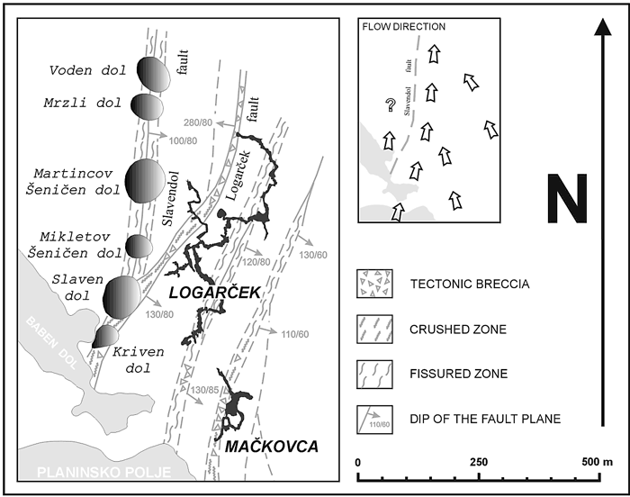
Fig.4. Geological and speleological details of the Logarcek area.
independent, completely separate, streams traverse beneath the “Main Channel”, approximately in a western direction. It appears that the passages are more or less embryonic, completely phreatic, and that one cannot yet speak about the “third” cave level 4.
Though the “Main Channel” is much more winding than in the previous two cases, the general trend is obvious. It is neither parallel to the polje margin nor to the local strike. Nevertheless, the relationship with tectonic structure is clear. 50m to 150m west of the “Main Channel” is the fracture zone of a fault several tens of metres wide, trending at about 020–200°. Šušteršič et al. (2001) called it the Logarcek Fault. Farther north it intercepts the “Main Channel”. This location is marked by a large chamber, named the Collapse Chamber (Podorna dvorana). The ground plan of the cave reveals that several branches of the cave become impenetrable5 in the proximity of the Logarcek Fault.
The only exception is the newly discovered passage. There, the location of the fault crossing is marked by a c.20m (high/deep6) phreatic jump. There is hardly a doubt that the phreatic jump formed as a consequence of the difficulties that the water faced when trying to cross the fault. As a general rule, similar jumps (or collapses) also appear at critical locations in other caves in the neighbourhood. On the other hand, no collapse doline is known on the Logarcek Fault, which appears to indicate that the fault differs in some aspect from those discussed above, in Postojnska jama and Karlovice.
The situations become comparable if considering the fault from which the Logarcek Fault diverges, a few hundred metres north of the polje (Car, 1982). It was the first identified in the area of the Slavendol collapse doline, and it was named the Slavendol Fault (Šušteršič et al. 2001). The known fault trace begins on the actual border of the polje and runs more or less northwards, veering a few degrees towards the east. Additional mapping revealed about 100m of dextral strike-slip movement in a horizontal sense, not disallowing the possibility of some vertical component.
Comparing this situation with the former two cases, it becomes evident that the Slavendol Fault, though somewhat more remote from the known cave passages than the Logarcek Fault, fits the concept of a deflector fault much better than the latter. The nature of the tectonic injuries to the rock, and the width of the Slavendol Fault zone, indicate that at the level of the present Logarcek “Main Channel” the fault zone is mechanically too weak to permit the formation of larger cave chambers. This made the sinking river wind, on the upstream side, along the Slavendol Fault and to shift the location of the break stepwise more and more northwards. In the horizontal plane the results of this route searching are collapse dolines. Vertically the process is testified by the remains of the phreatic jump, presently viewed as an apparently isolated “cave with shaft”, lying close to the fault zone, on its upstream side.
Within the trace of a wide shatter- to crush- and partly laminated-zone, there is a string of relatively “old” inactive, collapse, dolines. The volumes of most of these are so large that they could not have been formed just by sudden collapse of a cave chamber. In fact, steady removal of collapsed material must have lasted long after collapsing began. The stage reached by slope decay varies from doline to doline, testifying that they were not active at the same time. Considering the average denudation rate of 65m Ma-1 (Gams, 1966) and the expected rate of undercutting, one may expect that some of them are so old that they have become partly or even completely “ghost caves”7 . So, it is difficult to estimate the succession of their formation. On the other hand, they are quite regularly spaced. Whether this is related to periodic oscillation of fault zone cementation, as revealed on the surface, cannot be guessed until the fault has been reached in the cave.
Farther from the polje the string of collapses ends. As the surface elevation is increasing, the explanation that the rock mass above the cave has become too thick to allow collapse appears attractive. The volumes of the dolines do not confirm it, as the quantity of rock removed is so large that collapse would, nevertheless, have reached the surface. However, one should not exclude the possibility that the mechanical properties of the fault have changed to such an extent (Car and Gospodaric, 1985) that the cave roof became more stable. Additionally, increasing distance from the Idria Fault zone could also bring about this effect. Both options may even be involved. So, the possibility that waters from Logarcek cross the Slavendol Fault zone north of the doline string and eventually turn northwestwards remains open.
Nevertheless, if considering the hydrology of the Logarcek cave discussed above, it becomes evident that the modern collector channel, though not yet fully formed at its southernmost extension, must lie between the “Main Channel” and the Slavendol Fault.
Discussion
From the examples discussed it becomes clear that the concentration of channels parallel to certain faults reflects the “difficulties” water has faced when encountering the fracture zone of a deflector fault. Thus, collector channels can appear only on the upstream side of the obstacle. The exact mechanism of concentration is best displayed in the case of the Karlovice cave system (Fig.3), where the obstacle runs perfectly parallel to the outlet polje margin.
The example of Postojnska jama is rather less obvious, as the polje floor is not in karstic rock, but in flysch. Nevertheless, the present contact, though basically stratigraphical, has been strongly reworked tectonically. The slightly upwarped, impermeable, rim of the flysch area leads to water collecting mostly on the surface, and the collector channel is fed from the surface only by sparse but well-defined tributaries. As in the case of Karlovice, the collector channel runs parallel to the polje border and the tributaries are more or less perpendicular to both.
The situation is somewhat different with Logarcek. The angle between the polje border and the general direction of the cave is nearly 45°. The “Main Channel” appears to be a partly abandoned collector channel, whereas the present collector channel is, perhaps, just being formed. Similarities are better expressed by considering the relationship (parallelism) between the collector channel and the deflector fault (marked by collapse dolines). Relatively uniform cave channels meander approximately parallel to the fault zone, while upstream affluents join it (or presently cross it) at a gentle angle (Figs 4, 5).
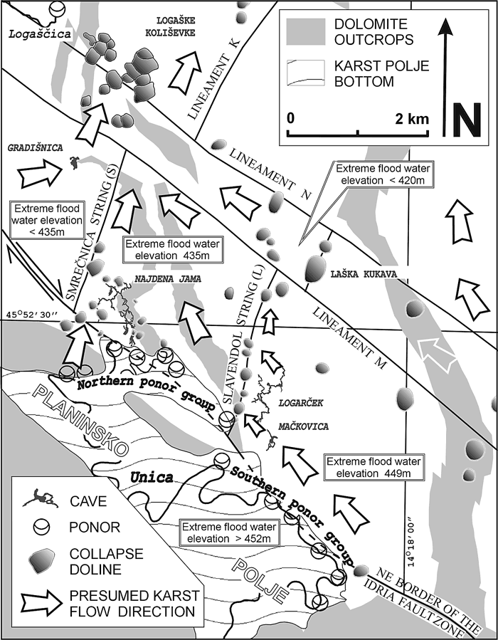
Fig 5. General location of Logarcek cave. (Based on Šušteršič, 2000b, revised on the basis of observations during the summer 2003 drought.)
Additionally, Logarcek is crossed by a swarm of faults (the Logarcek Fault and unnamed fractures lying farther to the east). They have largely impeded the flow but they did not influence the arrangement of the cave passages. This indicates that development of the cave system was gradual, in the sense that older faults guided the general direction of the flow corridor, whereas the younger ones influenced just the arrangement of particular channels.
Karstification attacks tectonically injured zones within the karstifiable rock, too, and the zones’ properties change with time (Car, 1982). In some places they are re-cemented, elsewhere they may become even more transmissive. The degree of change evidently depends upon the time that has elapsed since their formation or, perhaps more accurately, since active tectonism ceased. Thus, it would be expected that older faults should be more diverse, in the sense of highly transmissive portions alternating with virtually impermeable segments. A regular spatial distribution of attempted breakthrough locations and collapse dolines in the cases of Karlovice and of Logarcek might reflect uneven, but spatially regular “karstification” of the broken zones. In the case of the possibly younger fault at Postojnska jama the process might not have proceeded so far.
The relationship of the proximity/distance between collector channels and deflector faults should not be overlooked. In the case of Postojnska jama they are almost adjacent, whereas the distance is the greatest in the case of Logarcek. It seems that the amplitudes of winding of the collector channels increase in line with increased distance between the collector channel and the deflector fault. However, until more field examples are studied, this should be noted simply as an incidental observation. Until more field examples have been studied to a similar level of detail, the present findings should be considered more as an explanation of particular situations, than as a general rule.
Conclusions
- The collector channel is a positively defined element of the cave system with its own, specific individuality. It is connected causally with geological/tectonic structure and hydrogeological conditions within speleogenetic space.
- The collector channel is formed as a result of channel system reorganisation, and is a consequence of the presence of a less permeable and less stable fault zone perpendicular to the gradient direction.
- Nevertheless, some locations must initially have sufficient transmissivity perpendicular to the fault zone, so that the flow corridor does not form in a completely different direction.
- Due to its hydrogeological and speleogenetic role, the fault that brings about the formation of the collector channel is termed a deflector fault.
- The collector channel gathers underground streams that should cross the tectonically injured zone of the deflector fault. However, the latter generally does not let them through, and instead it directs them laterally.
- In cases where the deflector fault is close enough to the polje, sinking water joins it directly and the statement that collector channels run parallel to the polje margin holds true. However, the logical link is indirect.
- All three of the studied collector channels are epiphreatic, though none of them has developed a completely tunnel-like shape.
- Transformation of a fractured flow corridor into a conduit pattern is not guided only by local effects. Control is not only passive, and the passage pattern is not just a network of enlarged fissures.
- The mere existence of a (potential) deflector fault will (a) influence the choice of the proto-channels that will be further enlarged and (b) collapse due to conduit formation influenced the further development of the system. Thus, during cave system formation, any negative feedback processes that appear can guide the arrangement of the channel maze towards a predictable pattern.
Acknowledgments
The author thanks his colleagues Drs Joze Car and Stanka Sebela for the opportunity of putting the data of various sources together, and for fruitful discussions when developing the fundamental ideas. Dr Art Palmer is thanked for his encouraging comments. Dr Franci Gabrovsek is thanked for his important comments on the initial calculations about active collapse doline dynamics. Finally, thanks to Dr David J. Lowe for smoothing the raw English text and for the linguistic advice that made the ideas presentable to the international scientific community.
References
Cramer H. 1944. Die Systematik ser Karstdolinen. Neues Jahrbuch fur Mineralogie, Geologie und Palaontologie; Beilage Band, Abt. B, 85, 293-382.
Car J. 1982. Geologic setting of the Planinsko polje ponor area (In Slovene, English Summary). Acta carsologica 10, 75-105.
Car J. and Gospodaric R. 1984. About geology of karst among Postojna, Planina and Cerknica (In Slovene, English Summary). Acta carsologica 12, 91-106.
Car J. and Sebela S. 1997. Structural position of vertical karst objects on Postojnska Gmajna. Acta carsologica 26, 2, 295-314.
Gabrovsek F. 2000. Evolution of early karst aquifers: from simple principles to complex models. Ljubljana: 150 p.
Gams I. 1962. Logarcek (In Slovene, English Summary). Acta carsologica 3, 1-84.
Gams I. 1965. On the Quarternary geomorphogenesis of the area among the karst poljes of Postojna, Planina and Cerknica (In Slovene, English Summary). Geografski vestnik 37, 61-101.
Gams I. 1966. Factors and dynamics of corrosion of the carbonatic rocks in the Dinaric and Alpine karst of Slovenia (In Slovene, English Summary). Geografski vestnik 38, 11-68.
Gospodaric R. 1970. Speleological investigations of the Cerknica cave system (In Slovene, English Summary). Acta carsologica 5, 109-169.
Gospodaric R. 1976. The Qaurternary caves development between the Pivka basin and Polje of Planina (In Slovene, English Summary). Acta carsologica 7, 8-135.
Gospodaric R. and Habic P. 1979. Karst phenomena of Cerknisko polje (In Slovene, English Summary). Acta carsologica 8, 7-162.
Habic P. 1967. Nova odkritja v Veliki Karlovici (= New discoveries in Velika Karlovica / in Slovene only). Nase jame 9, 52-54.
Klimchouk A. B. and Ford D. C. 2000. Types of Karst and Evolution of Hydrogeologic Setting. In: Klimchouk A., Ford D., Palmer A. and Dreybrodt W. (Eds), Speleogenesis: Evolution of karst aquifers. Huntsville: Natl. Speleol. Soc., 45-53.
Klimchouk A. B., Ford D. C., Palmer A. N. and Dreybrodt W. (Eds). 2000. Speleogenesis: Evolution of Karst Aquifers. Huntsville, AL: National Speleological Society, 527 p.
Lauritzen S.E. and Lundberg J. 2000. Solutional and erosional morphology. In: Klimchouk A., Ford D., Palmer A. and Dreybrodt W. (Eds), Speleogenesis: Evolution of karst aquifers. Huntsville: Natl. Speleol. Soc., 408-426.
Michler I. and Hribar F. 1959. Contribution a la conaissance de la Pivka souterraine (In Slovene, French Summary). Acta carsologica 2, 157-195.
Palcic T. 2001. E-mail message, 15 Jan 2001.
Palmer A.N. 2000. Hydrogeologic control of cave patterns. In: Klimchouk A., Ford D., Palmer A. and Dreybrodt W. (Eds), Speleogenesis: Evolution of karst aquifers. Huntsville: Natl. Speleol. Soc., 77-90.
Sebela S. 1998. Tectonic structure of Postojnska jama cave system. Ljubljana, Zalozba ZRC 18, 112 p.
Sebela S. and Car J. 1991. Geological setting of collapsed chambers in Vzhodni rov in Predjama cave (In Slovene, English Summary). Acta carsologica 20, 205-222.
Šušteršič F. 1979. Some principles of the cave profiles simulation. In: Actes du symposium international sur l`erosion karstique: Aix-en-Provence-Marseille-Nimes 10-14 Septembre 1979, (Memoire, no. 1). Nimes: Association Francaise de Karstologie: Museum d'Histoire Naturelle, 1979, 125-131.
Šušteršič F. 1996. Poljes and caves of Notranjska. Acta carsologica 25, 251-289.
Šušteršič F. 1997. Rakovska kukava collapse or tumour doline? Acta carsologica 25, 251-289.
Šušteršič F. 1998. Interaction between the cave system and the lowering karst surface. Case study: Laski Ravnik. Acta carsologica 27, 2, 115-138.
Šušteršič F. 1999a. Is the karst becoming more predictable? Materials and Geoenvironment (RMZ) 46, 3, 583-599.
Šušteršič F. 1999b. Vertical zonation of the speleogenetic space. Acta carsologica 28, 2, 187-201.
Šušteršič F. 2000a. Speleogenesis in the Ljubljanica river drainage basin, Slovenia. In: Klimchouk A., Ford D., Palmer A. and Dreybrodt W. (Eds), Speleogenesis: Evolution of karst aquifers. Huntsville: Natl. Speleol. Soc., 397-406.
Šušteršič F. 2000b. Are "collapse dolines" formed only by collapse? Acta carsologica 29, 2, 251-289.
Šušteršič F. 2002. Where does underground Ljubljanica flow? Materials and geoenvironment (RMZ) 49,1, 61-84.
Šušteršič F. Car J. and Sebela, S. 2001. Collector channels and deflector faults (In Slovene, English Summary) Nase jame 43 8-22.
Šušteršič F. Šušteršič S. and Stepisnik U. 2002. Late pleistocene redirection of the Cerkniscica river: effect on the neighbouring karst. In: Gabrovsek F. (ed.). Evolution of karst: from prekarst to cessation (Carsologica). Postojna: Institut za raziskovanje krasa ZRC SAZU; Ljubljana: Zalozba ZRC, pp. 283-298.
Zupan Hajna N. 1995. Mineral composition of loams from different types of fault zones on Karst. In: Vlahovic I. Velic I. and Sparica M. (Eds.). 2000. Zbornik radova, Institut za geoloska istrazivanja, 657-660.
Zalec P. Vrhovec T. Mihailovski M. Zwolf D. and Drole F. 1997. Jamski sitem Zelske jame-Karlovica [Cave system Zelske jame-Karlovica / in Slovene only]. Nase jame 39, 87-94.
1 The same concept was proposed by Sustersic (1979), as a purely theoretical background for mathematical modeling of cave conduit cross sections, and "active" and "passive" variables were termed factors.
<< Back
2 The largest one in the Ljubljanica catchment, named Laska kukava, exceeds 4 Mm3, whereas the average appears to be several hundred thousand m3 (Sustersic, 2000b). However, features smaller than a few thousand m3 are hardly distinguishable from other types of closed depressions within the karst surface.
<< Back
3 In the English summary Gams did not mention collector channels directly, as he was focussing on other topics. The present English term “collector channel” was first used by Sustersic et al. (2001), according to the suggestion of Dr. David J. Lowe.
<< Back
4 During the extreme drought of summer 2003, the watertable within the cave dropped to about 20m below the usual »low water« level, and some »permanent« pools dried up. In one of them cavers were able to penetrate between boulders to enter a vertical shaft with a »lake« at its foot. A diving attempt in the muddy water revealed that the drowned vertical shaft continues downwards for more than a dozen metres. This indicates that an extensive phreatic maze probably exists below the level of the "Main Channel"
<< Back
5 The nature of the obstacles is usually obscured by massive loam deposits.
<< Back
6 Considering the present situation it is “deep”. Sustersic (2002), however, demonstrated that there is no reason to believe that the evolution of the caves around Planinsko polje was straightforward. One cannot guess whether the initial stream flow was opposite to or the same as the present direction.
<< Back
7 Sensu Sustersic (1999a) these are “phantom caves”. However, considering that this term has been used in different contexts by other authors, the alternative and less ambiguous expression “ghost cave” is now proposed for future use, to avoid confusion.
<< Back